
Binghamton is a city in the U.S. state of New York, and serves as the county seat of Broome County. Surrounded by rolling hills, it lies in the state's Southern Tier region near the Pennsylvania border, in a bowl-shaped valley at the confluence of the Susquehanna and Chenango Rivers. Binghamton is the principal city and cultural center of the Binghamton metropolitan area, home to a quarter million people. The city's population, according to the 2020 census, is 47,969.

Endwell is a hamlet located in the town of Union in Broome County, New York, United States. Its population was 11,446 at the 2010 census.

Port Dickinson is a village in Broome County, New York, United States. The population was 1,641 at the 2010 census. It is part of the Binghamton Metropolitan Statistical Area.

Barrhaven is a suburb of Ottawa, Ontario, Canada. It is located about 17 km (11 mi) southwest of the city's downtown core. Prior to amalgamation with Ottawa in 2001, Barrhaven was part of the City of Nepean. Its population as of the Canada 2021 Census was 103,234.

The Greater Grand Forks Greenway is a huge greenway bordering the Red River and Red Lake River in the twin cities of Grand Forks, North Dakota and East Grand Forks, Minnesota. At 2,200 acres (9 km2), the Greenway is more than twice the size of New York City's Central Park. It has an extensive, 20-mile (32 km) system of bike paths, which are used by bikers, walkers, joggers, and rollerbladers. In 2007, the system was designated as a National Recreation Trail by the National Park Service.
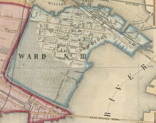
East Cambridge is a neighborhood of Cambridge, Massachusetts. East Cambridge is bounded by the Charles River and the Charlestown neighborhood of Boston on the east, the Somerville border on the north, Broadway and Main Street on the south, and the railroad tracks on the west. Most of the streets form a grid aligned with Cambridge Street, which was laid out to directly connect what is now the Charles River Dam Bridge with what in 1809 was the heart of Cambridge, Harvard Square. The northern part of the grid is a roughly six by eight block residential area. Cambridge Street itself is retail commercial, along with Monsignor O'Brien Highway, the Twin Cities Plaza strip mall, and the enclosed Cambridgeside Galleria. Lechmere Square is the transportation hub for the northern side. The southern half of the grid is largely office and laboratory space for hundreds of dot-com companies, research labs and startups associated with MIT, biotechnology firms including Genzyme, Biogen and Moderna, the Athenaeum Press Building, light industry, an NRG Energy power station, and various small businesses. This half of the neighborhood is generally identified with Kendall Square. Along the waterfront are several hotels and taller apartment buildings.

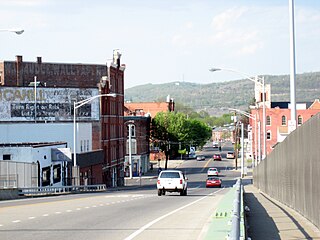
Downtown Harrisburg is the central core neighborhood, business and government center which surrounds the focal point of Market Square, and serves as the regional center for the greater metropolitan area of Harrisburg, Pennsylvania, United States.

New York State Route 17C (NY 17C) is a state highway in the Southern Tier of New York in the United States. Its western terminus is at an intersection with NY 34 in Waverly, Tioga County while its eastern terminus is at an intersection with U.S. Route 11 (US 11) in Binghamton, Broome County. The route runs concurrently with NY 96 for a block in Owego and for a few blocks with NY 26 in Endicott.

Riverside is a neighborhood of Buffalo, New York, located in the northwestern part of the city, along the Niagara River. It is sometimes referred to in conjunction with another community located directly south, Black Rock.
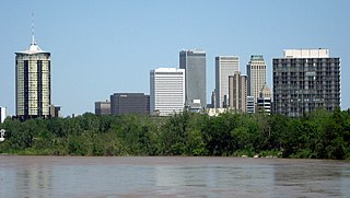
Tulsa is the second-largest city in the state of Oklahoma. It has many diverse neighborhoods due to its size.

The East Side is a district of Milwaukee, Wisconsin consisting of several neighborhoods encompassing an area just north of Downtown Milwaukee to the village of Shorewood, bordered by the Milwaukee River to the west and Lake Michigan to the east. The area encompasses residences, museums, bars, shops, theaters, live music clubs and the University of Wisconsin–Milwaukee campus.

There are more than 500 neighborhoods within the area of Jacksonville, Florida, the largest city in the contiguous United States by area. These include Downtown Jacksonville and surrounding neighborhoods. Additionally, greater Jacksonville is traditionally divided into several major sections with amorphous boundaries: Northside, Westside, Southside, and Arlington, as well as the Jacksonville Beaches.

Neighborhoods in Spokane, Washington are officially grouped by the Spokane City Council into three main city council districts: 1, 2, and 3. Each city council district contains multiple, official neighborhoods that are recognized with a neighborhood council. Informally, neighborhoods are colloquially grouped by local geographical, geological, cultural, or historical features The list of neighborhoods below is organized based on the official designations by the City of Spokane. Unofficial neighborhoods and districts are listed within the official neighborhood in which they are located.
New York State Route 201 (NY 201) is a north–south state highway located west of the city of Binghamton in Broome County, New York. The southern terminus of the route is at NY 434 in Vestal while the northern terminus is at an interchange with NY 17 in Johnson City.

Downtown Spokane or Riverside is the central business district of Spokane, Washington. The Riverside neighborhood is roughly bounded by I-90 to the south, Division Street to the east, Monroe Street to the west and Boone Avenue to the north. The topography of Downtown Spokane is mostly flat except for areas downstream of the Spokane Falls which are located in a canyon; the elevation is approximately 1,900 feet (580 m) above sea level.
The following is a list of neighborhoods and commercial districts in Sioux City, Iowa.

Downtown Binghamton is a neighborhood in Binghamton, New York, located on the north bank of the Susquehanna River, just east of its confluence with the Chenango River. It is the business and administrative center of the City of Binghamton, the Greater Binghamton area and Broome County.
The East Side, as the name implies, is a neighborhood in the eastern section of the New York State city of Binghamton. It is primarily an urban residential neighborhood with retail along Court and Robinson streets and pockets of industry scattered along the train tracks.
The North Side is a neighborhood in northern section of the New York State city of Binghamton. It is a mixed-use urban neighborhood with commercial and industrial businesses many times occupying sections of residential blocks.

