Doyle Township, Michigan | |
|---|---|
 The community of Gulliver along U.S. Route 2 | |
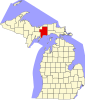
 Location within Schoolcraft County | |
 Doyle Township Location within the state of Michigan  Doyle Township Doyle Township (the United States) | |
| Coordinates: 46°07′01″N86°01′51″W / 46.11694°N 86.03083°W | |
| Country | United States |
| State | Michigan |
| County | Schoolcraft |
| Established | 1890 |
| Government | |
| • Supervisor | Lynn Norton |
| • Clerk | Patti Hoffman |
| Area | |
• Total | 154.19 sq mi (399.4 km2) |
| • Land | 146.12 sq mi (378.4 km2) |
| • Water | 8.07 sq mi (20.9 km2) |
| Elevation | 669 ft (204 m) |
| Population (2020) | |
• Total | 563 |
| • Density | 3.7/sq mi (1.4/km2) |
| Time zone | UTC-5 (Eastern (EST)) |
| • Summer (DST) | UTC-4 (EDT) |
| ZIP code(s) | |
| Area code | 906 |
| FIPS code | 26-22960 [1] |
| GNIS feature ID | 1626192 [2] |
| Website | Official website |
Doyle Township is a civil township of Schoolcraft County in the U.S. state of Michigan. [3] The population was 563 in 2020. [4] This area is known for its pristine beaches on Lake Michigan and inland lakes, such as Gulliver Lake, McDonald Lake, and Clear Lake, among others.