Athens is the capital and largest city of Greece. A major coastal urban area in the Mediterranean, Athens is also the capital of the Attica region and is the southernmost capital on the European mainland. With its urban area's population numbering over three and a quarter million, it is the eighth largest urban area in the European Union. The Municipality of Athens, which constitutes a small administrative unit of the entire urban area, had a population of 643,452 (2021) within its official limits, and a land area of 38.96 km2 (15.04 sq mi).

Piraeus is a port city within the Athens urban area, in the Attica region of Greece. It is located eight kilometres (5 mi) southwest of Athens city centre along the east coast of the Saronic Gulf in the Athens Riviera.
Acharnes is a municipality in the East Attica regional unit in Greece. With 108,169 inhabitants, it is the ninth most populous municipality in Greece. It lies just north of the Athens urban area.

Ampelakia is a town and a former municipality of Salamis Island, Greece. Since the 2011 local government reform it is part of the municipality Salamis, of which it is a municipal unit.
Tavros, is a town and a suburb in the southwestern part of the Athens agglomeration, Greece. Since the 2011 local government reform it is part of the municipality Moschato-Tavros, of which it is a municipal unit.

Agios Ioannis Renti is a suburb and a former municipality in the Piraeus regional unit, lying in the western part of the Athens agglomeration, Greece. Since the 2011 local government reform it is part of the municipality Nikaia-Agios Ioannis Renti, of which it is a municipal unit.

Moschato is a town and a suburb in the southwestern part of the Athens agglomeration, Greece. Since the 2011 local government reform it is part of the municipality Moschato-Tavros, of which it is the seat and a municipal unit.

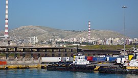
Keratsini is a suburban town in the western part of the Piraeus regional unit, which in turn is a part of the Athens Urban Area. Since the 2011 local government reform it is part of the municipality Keratsini-Drapetsona, of which it is the seat and a municipal unit.

Nikaia, known before 1940 as Kokkinia, is a town and a suburb of the Piraeus agglomeration, in the southwestern part of the Athens urban area, Greece. Since the 2011 local government reform it is part of the municipality Nikaia-Agios Ioannis Rentis in the regional unit of Piraeus, and it is the seat and a municipal unit of the municipality.

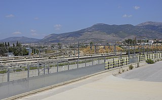
Ano Liosia is a town and a former municipality in the northern part of the Athens agglomeration, Greece. Since the 2011 local government reform it is part of the municipality Fyli, of which it is the seat and a municipal unit. The municipal unit has an area of 38.447 km2.

Pallini is a suburban town in Greater Athens Area and a municipality in East Attica, Greece. The seat of the municipality is the town Gerakas. It is the seat of administration of the East Attica regional unit.

Litochoro is a town and a former municipality in the southern part of the Pieria regional unit, Macedonia, Greece. Since the 2011 local government reform it has been part of the Dio-Olympos municipality, of which it is the seat and a municipal unit. It is located at the base of Mount Olympus, on the western shore of the Thermaic Gulf. The first recorded mention of Litochoro is in an account of a visit by Saint Dionysius to Mount Olympus in the 16th century. The town is a popular destination for those wishing to climb Mount Olympus as almost all climbing routes begin to the southwest of the town. One of the most famous Litohorians was Christos Kakkalos, who made the first modern unaided ascent of Mount Olympus in 1913.

Rafina is a suburban port town located on the eastern coast of Attica in Greece. It has a population of 14,620 inhabitants. Since the 2011 local government reform it is part of the municipality Rafina-Pikermi, of which it is the seat and a municipal unit. The municipal unit has an area of 18.979 km2. It is part of Athens metropolitan area.

Platy is a town and a municipality in eastern Imathia, Greece. Since the 2011 local government reform it is part of the municipality Alexandreia, of which it is a municipal unit. The municipal unit has an area of 181.375 km2.

Keratea is a town in East Attica, Greece. Since the 2011 local government reform it is part of the municipality Lavreotiki, of which it is a municipal unit. The municipal unit has an area of 129.864 km2. It is part of Athens metropolitan area.

Ermoupoli, also known by the formal older name Ermoupolis or Hermoupolis, is a town and former municipality on the island of Syros, in the Cyclades, Greece. Since the 2011 local government reform, it is part of the municipality Syros-Ermoupoli, of which it is the seat and a municipal unit. It is also the capital of the South Aegean region. The municipal unit has an area of 11.181 km2.

Piraeus, also sometimes called Greater Piraeus, is one of the regional units of Greece. It is part of the region of Attica. The regional unit covers the west-central part of the Athens urban area.

Keratsini-Drapetsona is a municipality in the Piraeus regional unit, Attica, Greece. The seat of the municipality is the town of Keratsini. The municipality has a population of 89,386 inhabitants, according to the 2021 census and an area of 9.326 square kilometres (3.601 sq mi).

Piraeus B is a Greek election constituency that includes the Piraeus regional unit municipalities and Salamina. Concretely, this constituency includes the municipalities of Keratsini-Drapetsona, Nikaia-Agios Ioannis Renti, Korydallos, Perama and Salamina. It was created for the 1974 Greek parliament elections and currently elects 8 members of parliament. It is one of five electoral constituencies of the Attica region and former prefecture, along with Piraeus A, Athens A and Athens B, and Remainder of Attica. It was established in 1958, primarily to separate the heavily left-voting suburbs of Piraeus from the municipality of Piraeus and diminish the electoral power of the United Democratic Left.
The Kanellopoulos Institute of Chemistry and Agriculture is a former research institute in Drapetsona, Athens, Greece, which operated between 1938 and 1984 in affiliation with the Drapetsona-based Greek Company of Chemical Products and Fertilisers.