Draycote

Last updated

Draycote
Draycote - geograph.org.uk - 18692.jpg
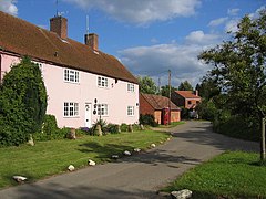
Houses in Draycote
Warwickshire UK location map.svg
Red pog.svg
Draycote
Location within Warwickshire
OS grid reference SP4470
Civil parish
District
Shire county
Region
Country England
Sovereign state United Kingdom
Post town RUGBY
Postcode district CV23
Dialling code 01926
Police Warwickshire
Fire Warwickshire
Ambulance West Midlands
UK Parliament
List of places
UK
England
Warwickshire
52°19′33″N1°20′55″W / 52.325968°N 1.348509°W / 52.325968; -1.348509

Draycote is a small hamlet in Warwickshire, England. It forms part of the civil parish of Bourton and Draycote along with nearby Bourton-on-Dunsmore, which is located around half a mile to the west, uphill from Draycote.

Draycote is located in a valley just to the west of Draycote Water reservoir, which is named after the hamlet and is home to Draycote Water Sailing Club.

Draycote is quite remote, with only one narrow lane accessing the village from the B4453 road, which then loops back towards Bourton-on-Dunsmore.

The remains of the former Rugby to Leamington Spa railway line run west of Draycote. Part of the former line between Draycote and Birdingbury has recently been converted into a cycleway as part of the National Cycle Network.

Near the village is the Draycote Meadows nature reserve.

Related Research Articles

<span class="mw-page-title-main">Borough of Rugby</span> Borough and non-metropolitan district in England

The Borough of Rugby is a local government district with borough status in Warwickshire, England. The borough comprises the town of Rugby where the council has its headquarters, and the rural areas surrounding the town. At the 2021 census the borough had a population of 114,400, of which 78,125 lived in the built-up area of Rugby itself and the remainder were in the surrounding areas.

<span class="mw-page-title-main">Warwickshire</span> County of England

Warwickshire is a ceremonial county in the West Midlands of England. It is bordered by Staffordshire and Leicestershire to the north, Northamptonshire to the east, Oxfordshire and Gloucestershire to the south, and Worcestershire and the West Midlands county to the west. The largest settlement is Nuneaton and the county town is Warwick.

Bourton is the name of more than one place in England:

<span class="mw-page-title-main">Draycote Water</span> Reservoir in Warwickshire, England

Draycote Water is a 240-hectare (590-acre) reservoir and country park near the village of Dunchurch, 3.75 miles (6 km) south of Rugby in Warwickshire, England, owned and operated by Severn Trent Water. It draws its water from the River Leam, and supplies drinking water to Rugby and Coventry. It is named after the nearby hamlet of Draycote and is the largest body of water within Warwickshire.

<span class="mw-page-title-main">Bourton-on-the-Water</span> Village in England

Bourton-on-the-Water is a village and civil parish in Gloucestershire, England, that lies on a wide flat vale within the Cotswolds Area of Outstanding Natural Beauty. The village had a population of 3,296 at the 2011 census. Much of the village centre is a designated Conservation Area.

<span class="mw-page-title-main">Princethorpe</span> Human settlement in England

Princethorpe is a village and civil parish in the Rugby district of Warwickshire, England. In the 2011 census the parish had a population 376, increasing to 429 at the 2021 census.

<span class="mw-page-title-main">Thurlaston, Warwickshire</span> Human settlement in England

Thurlaston is a village and civil parish in the Rugby district of Warwickshire, England. According to the 2001 census the parish had a population of 352, increasing to 368 at the 2011 census, and again to 379 at the 2021 census.

The Rugby Rural District was a former rural district in Warwickshire, England. The district covered the rural areas surrounding the town of Rugby, where the district council was based, but did not include Rugby itself which was administered separately.

Brownsover is a residential and commercial area of Rugby, Warwickshire in England, about 1+12 miles north of the town centre. The area is named after the original hamlet of Brownsover. Since 1960, the area has been subsumed by the expansion of Rugby, with the construction of a number of housing estates, industrial estates and retail parks.

<span class="mw-page-title-main">Ibstock</span> Human settlement in England

Ibstock is a former coal mining town and civil parish about 3 miles (5 km) south of Coalville in North West Leicestershire, England. The population of the civil parish was 5,760 at the 2001 census increasing to 6,201 at the 2011 census and 7,615 at the 2021 census.

<span class="mw-page-title-main">Kites Hardwick</span>

Kites Hardwick is a hamlet in east Warwickshire, England, in the Leam Valley ward of Rugby Borough and in the civil parish of Leamington Hastings The village straddles the A426 Rugby to Southam road two miles (3 km) south of Dunchurch. It lies in the valley of the River Leam which passes under the A426 at Thurlaston Bridge, just north of Kites Hardwick. This spot was the location of frequent flooding of the road until in 2001 the Environment Agency constructed a gauging station immediately west of the bridge with associated works to ease the flow of the river.

<span class="mw-page-title-main">Bourton-on-Dunsmore</span> Human settlement in England

Bourton-on-Dunsmore is a small village in Warwickshire, England. It is within the civil parish of Bourton and Draycote, along with the nearby hamlet of Draycote.

Bourton and Draycote is a civil parish in the Rugby borough of Warwickshire, England which consists of the villages of Bourton-on-Dunsmore and Draycote. Of these, Bourton is the larger. In the 2001 Census the parish had a population of 231, increasing to 275 at the 2011 Census, decreasing slightly to 271 at the 2021 Census.

<span class="mw-page-title-main">Leamington Hastings</span> Human settlement in England

Leamington Hastings is a small village and larger civil parish in Warwickshire, England. The civil parish covers Leamington Hastings itself, plus the nearby hamlets of Broadwell, Hill and Kites Hardwick. Its population in the 2011 census was 440, increasing slightly to 466 at the 2021 census.

<span class="mw-page-title-main">Birdingbury</span> Human settlement in England

Birdingbury is a village and civil parish in the Rugby district of Warwickshire, England, just south of the River Leam, and not far from Draycote Water. It is located roughly halfway between Rugby and Leamington Spa, about eight miles from each. According to the 2001 census it had a population of 327, increasing to 362 at the 2011 Census, decreasing to 341 at the 2021 Census.

Draycott, Draycot or Draycote may refer to:

Toft is a small hamlet in the county of Warwickshire, England, just south of, and within the civil parish of Dunchurch, just off the A426 road and south of the M45 motorway. To the west Toft overlooks Draycote Water, across which lies the village of Thurlaston. The hamlet was first mentioned in the 15th century. It sits on a hill known as Toft Hill.

<span class="mw-page-title-main">Eathorpe</span>

Eathorpe is a small village and civil parish five miles east of Leamington Spa, in Warwickshire, England. The parish is part of the electoral ward of Cubbington. It is close to the B4455, which follows the line of the Roman Fosse Way, and the River Leam. According to the 2001 census, the parish had a population of 113, increasing to 190 at the 2011 census. The village has a village hall, the original being built in the early 1970s. The only public house is The Plough, an 18th-century former coaching inn situated beside the Fosse Way.

<span class="mw-page-title-main">Clifton-upon-Dunsmore</span> Human settlement in England

Clifton-upon-Dunsmore is a village and civil parish in the Rugby borough of Warwickshire in England on the north-eastern outskirts of Rugby, approximately 2 miles (3.2 km) from Rugby town centre. The population of the parish taken at the 2011 census was 1,304, increasing to 2,991 at the 2021 census. Clifton is counted as being part of the Rugby built-up area, but is considered separate from the town. The parish also includes the new development of Houlton to the south of the old village, which may account for the large population increase since 2011.

References

Commons-logo.svg Media related to Draycote at Wikimedia Commons