Bourton-on-Dunsmore

Last updated

Bourton on Dunsmore
Church of St Peter and war memorial, Bourton-On-Dunsmore - geograph.org.uk - 1483864.jpg
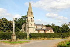
Church of St Peter and war memorial, Bourton-on-Dunsmore
Warwickshire UK location map.svg
Red pog.svg
Bourton on Dunsmore
Location within Warwickshire
OS grid reference SP4370
Civil parish
District
Shire county
Region
Country England
Sovereign state United Kingdom
Post town RUGBY
Postcode district CV23
Police Warwickshire
Fire Warwickshire
Ambulance West Midlands
List of places
UK
England
Warwickshire
52°19′47″N1°21′40″W / 52.329823°N 1.361149°W / 52.329823; -1.361149

Bourton-on-Dunsmore is a small village in Warwickshire, England. It is within the civil parish of Bourton and Draycote, along with the nearby hamlet of Draycote.

Bourton is part of the borough of Rugby and is located around 5 miles (8.0 km) south-west of the town of Rugby, just south of the B4453 road. Bourton is located upon a ridge of high ground overlooking the Draycote Water reservoir. A short distance to the east, downhill of Bourton is the hamlet of Draycote, and a short distance west is the village of Frankton.

Bourton-on-Dunsmore was mentioned in the Domesday Book of 1086. The village church of St Peter dates to the 13th century, but was mostly rebuilt in the 19th century, it is now grade II listed. [1]

In the village is the grade II listed Bourton Hall; a large stone mansion house which dates from 1791, with later additions. [2] It once had gardens designed by Harold Peto, but had fallen into dereliction by the early-1980s. [3] It was restored, and for many years was the headquarters of the development charity Practical Action (formerly known as Intermediate Technology). [4] In 2019 the hall was bought by a company who sought to convert it into a luxury wedding venue. In 2021 the company was fined for carrying out renovation work to the hall without planning permission. [5]

Related Research Articles

<span class="mw-page-title-main">Rugby, Warwickshire</span> Town in Warwickshire, England

Rugby is a market town in eastern Warwickshire, England, close to the River Avon. At the 2021 census, its population was 78,117, making it the second-largest town in Warwickshire. It is the main settlement within the larger Borough of Rugby, which had a population of 114,400 in 2021.

<span class="mw-page-title-main">Borough of Rugby</span> Borough and non-metropolitan district in England

The Borough of Rugby is a local government district with borough status in Warwickshire, England. The borough comprises the town of Rugby where the council has its headquarters, and the rural areas surrounding the town. At the 2021 census the borough had a population of 114,400, of which 78,125 lived in the built-up area of Rugby itself and the remainder were in the surrounding areas.

<span class="mw-page-title-main">Dunchurch</span> Human settlement in England

Dunchurch is a large village and civil parish on the south-western outskirts of Rugby in Warwickshire, England, approximately 2.5 miles (4.0 km) southwest of central Rugby. The civil parish, which also includes the nearby hamlet of Toft, had a population of 4,123 at the 2021 Census, a significant increase from 2,938 at the 2011 Census.

<span class="mw-page-title-main">Draycote Water</span> Reservoir in Warwickshire, England

Draycote Water is a 240-hectare (590-acre) reservoir and country park near the village of Dunchurch, 3.75 miles (6 km) south of Rugby in Warwickshire, England, owned and operated by Severn Trent Water. It draws its water from the River Leam, and supplies drinking water to Rugby and Coventry. It is named after the nearby hamlet of Draycote and is the largest body of water within Warwickshire.

<span class="mw-page-title-main">Bourton-on-the-Water</span> Village in England

Bourton-on-the-Water is a village and civil parish in Gloucestershire, England, that lies on a wide flat vale within the Cotswolds Area of Outstanding Natural Beauty. The village had a population of 3,296 at the 2011 census. Much of the village centre is a designated Conservation Area.

<span class="mw-page-title-main">Hillmorton</span> Human settlement in England

Hillmorton is a suburb of Rugby, Warwickshire, England, around 2 miles (3.2 km) south-east of Rugby town centre, forming much of the eastern half of the town. It is also a ward of the Borough of Rugby. Hillmorton was historically a village in its own right, but was incorporated into Rugby in 1932. Hillmorton also encompasses the Paddox housing estate to the west of the old village, which is shown on many maps as 'Hillmorton Paddox', this area however is part of a separate ward called 'Paddox'.

<span class="mw-page-title-main">Thurlaston, Warwickshire</span> Human settlement in England

Thurlaston is a village and civil parish in the Rugby district of Warwickshire, England. According to the 2001 census the parish had a population of 352, increasing to 368 at the 2011 census, and again to 379 at the 2021 census.

The Rugby Rural District was a former rural district in Warwickshire, England. The district covered the rural areas surrounding the town of Rugby, where the district council was based, but did not include Rugby itself which was administered separately.

Brownsover is a residential and commercial area of Rugby, Warwickshire in England, about 1+12 miles north of the town centre. The area is named after the original hamlet of Brownsover. Since 1960, the area has been subsumed by the expansion of Rugby, with the construction of a number of housing estates, industrial estates and retail parks.

<span class="mw-page-title-main">Bilton, Warwickshire</span> Suburb of Rugby in Warwickshire, England

Bilton is a suburb of Rugby in Warwickshire, England, located about 1.5 miles (2.4 km) south-west of Rugby town centre. It is also a ward of the Borough of Rugby, which at the 2021 Census had a population of 6,544. It comprises much of the western half of the town. Historically a village in its own right, Bilton was incorporated into Rugby in 1932.

Bourton and Draycote is a civil parish in the Rugby borough of Warwickshire, England which consists of the villages of Bourton-on-Dunsmore and Draycote. Of these, Bourton is the larger. In the 2001 Census the parish had a population of 231, increasing to 275 at the 2011 Census, decreasing slightly to 271 at the 2021 Census.

<span class="mw-page-title-main">Draycote</span> Human settlement in England

Draycote is a small hamlet in Warwickshire, England. It forms part of the civil parish of Bourton and Draycote along with nearby Bourton-on-Dunsmore, which is located around half a mile to the west, uphill from Draycote.

<span class="mw-page-title-main">Leamington Hastings</span> Human settlement in England

Leamington Hastings is a small village and larger civil parish in Warwickshire, England. The civil parish covers Leamington Hastings itself, plus the nearby hamlets of Broadwell, Hill and Kites Hardwick. Its population in the 2011 census was 440, increasing slightly to 466 at the 2021 census.

<span class="mw-page-title-main">Birdingbury</span> Human settlement in England

Birdingbury is a village and civil parish in the Rugby district of Warwickshire, England, just south of the River Leam, and not far from Draycote Water. It is located roughly halfway between Rugby and Leamington Spa, about eight miles from each. According to the 2001 census it had a population of 327, increasing to 362 at the 2011 Census, decreasing to 341 at the 2021 Census.

<span class="mw-page-title-main">Great Bourton</span> Human settlement in England

Great Bourton is a village about 3 miles (5 km) north of Banbury in Oxfordshire, England. It is the largest settlement in the civil parish of Bourton. The 2011 Census recorded the parish's population as 614.

<span class="mw-page-title-main">Scalford</span> Village in Leicestershire, England

Scalford is a village and civil parish in the Melton borough of Leicestershire, England. It lies 4 miles (6.4 km) to the north of Melton Mowbray at the southern end of the Vale of Belvoir. In the 2011 census the parish had a population of 608.

<span class="mw-page-title-main">Church Lawford</span> Human settlement in England

Church Lawford is a village and civil parish in Warwickshire, England. It is located just under 2.5 miles (4 km) west of the town of Rugby and 4.5 miles (7 km) east of Coventry. The population of the civil parish taken at the 2021 census was 432.

<span class="mw-page-title-main">Clifton-upon-Dunsmore</span> Human settlement in England

Clifton-upon-Dunsmore is a village and civil parish in the Rugby borough of Warwickshire in England on the north-eastern outskirts of Rugby, approximately 2 miles (3.2 km) from Rugby town centre. The population of the parish taken at the 2011 census was 1,304, increasing to 2,991 at the 2021 census. Clifton is counted as being part of the Rugby built-up area, but is considered separate from the town. The parish also includes the new development of Houlton to the south of the old village, which may account for the large population increase since 2011.

<span class="mw-page-title-main">St Michael and All Angels Church, Brownsover</span> Church in Warwickshire, England

St Michael and All Angels Church is a redundant Anglican church in the former village of Brownsover, which is now a suburb of the town of Rugby, Warwickshire, England. It is recorded in the National Heritage List for England as a designated Grade II* listed building, and is under the care of the Churches Conservation Trust.

References

  1. "ST. PETER'S CHURCH, BOURTON ON DUNSMORE". Our Warwickshire. Retrieved 19 October 2019.
  2. "BOURTON HALL AND ATTACHED FORMER CATHOLIC CHAPEL". Historic England. Retrieved 18 February 2021.
  3. "BOURTON HALL PARK/GARDEN, BOURTON ON DUNSMORE, RUGBY". Our Warwickshire. Retrieved 18 February 2021.
  4. "Royal Engagements". 21 September 2011. Retrieved 18 February 2021.
  5. "Luxury wedding firm fined for renovating listed building without consent". Coventry Telegraph. Retrieved 18 February 2021.

Commons-logo.svg Media related to Bourton-on-Dunsmore at Wikimedia Commons