
Campbelltown is a suburb located on the outskirts of the metropolitan area of Sydney, New South Wales, Australia. It is located in Greater Western Sydney 53 kilometres (33 mi) south-west of the Sydney central business district by road. Campbelltown is the administrative seat of the local government area of the City of Campbelltown. It is also acknowledged on the register of the Geographical Names Board of New South Wales as one of only four cities within the Sydney metropolitan area.

Camden is a historic town and suburb of Sydney, New South Wales, located 65 kilometres south-west of the Sydney central business district. Camden was the administrative centre for the local government area of Camden Council until July 2016 and is a part of the Macarthur region.

Varroville is a suburb of Sydney, in the state of New South Wales, Australia. Varroville is located 46 kilometres south-west of the Sydney central business district, in the local government area of the City of Campbelltown and is part of the Macarthur region. Varroville forms part of the scenic hills on the north-west side of the M5 South Western Motorway between Campbelltown and the Camden Valley Way. Of all Sydney suburbs, Varroville has the highest proportion of residents with PhDs.

The City of Campbelltown is a local government area in the Macarthur region of south-western Sydney, in New South Wales, Australia. The area is located about 55 kilometres (34 mi) south west of the Sydney central business district and comprises 312 square kilometres (120 sq mi).
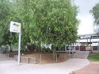
Minto is a suburb of Sydney, in the state of New South Wales, Australia. Minto is located 50 kilometres south-west of the Sydney central business district, in the local government area of the City of Campbelltown and is part of the Macarthur region.
Ingleburn is a suburb of Sydney, in the state of New South Wales, Australia, 45 kilometres (28 mi) south-west of the Sydney central business district, in the local government area of City of Campbelltown. It is part of the Macarthur region. Ingleburn is located approximately halfway between the two commercial centres of Liverpool and Campbelltown.
Gilead is a suburb of Sydney, in the state of New South Wales, Australia. Gilead is located 58 kilometres south-west of the Sydney central business district, in the local government area of the City of Campbelltown and is part of the Macarthur region.

The Cataract Dam is a heritage-listed dam in Cataract, New South Wales, Australia, provides water to the Macarthur and Illawarra regions, the Wollondilly Shire, and metropolitan Sydney. It is one of four dams and weirs in the catchment of the Upper Nepean Scheme. Completed in 1907 under the supervision of Ernest Macartney de Burgh, the dam is currently owned by Water NSW, an agency of the Government of New South Wales. The dam was listed on the NSW State Heritage Register on 18 November 1999.

Macarthur is a region in the south-west part of the Greater Sydney area, in the state of New South Wales, Australia. The region includes the local government areas of the City of Campbelltown, Camden Council, and Wollondilly Shire. It covers an area of 3,067 square kilometres and has a population of close to 310,000 residents. The region geographically forms the foothills between the Blue Mountains and Southern Highlands regions.

Appin is a town on the south-west fringe of Sydney in the Macarthur Region in Tharawal country near its boundary with Gandangara country, New South Wales, Australia in Wollondilly Shire. It is situated about 16 kilometres (9.9 mi) south of Campbelltown and 35 kilometres (22 mi) northwest of Wollongong.

Elizabeth Macquarie was the second wife of Lachlan Macquarie, who served as Governor of New South Wales from 1810 to 1821. She played a significant role in the establishment of the colony and is recognised in the naming of many Australian landmarks including Mrs Macquarie's Chair and Elizabeth Street, Hobart. Governor Macquarie named the town of Campbelltown, New South Wales after his wife's maiden name and a statue of her now stands in Mawson Park, Campbelltown.
Windmill Hill is a heritage-listed former farm and now water catchment area located at Wilton Road in the outer south-western Sydney settlement of Appin in the Wollondilly Shire local government area of New South Wales, Australia. It was built from 1820 to 1950. It is also known as Windmill Hill Group, including Ruins, North Farm, Middle Farm aka Larkin Farm and Windmill Hill, South Farm and Steven's Homestead. The property is owned by Water NSW. It was added to the New South Wales State Heritage Register on 27 June 2014.
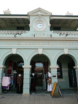
The Campbelltown Post Office is a heritage-listed former post office and now shops and office space at 261 Queen Street, Campbelltown, New South Wales, a suburb of Sydney, Australia. It was designed by James Barnet and built in 1881. It is also known as Campbelltown Post Office (former). The property is privately owned. It was added to the New South Wales State Heritage Register on 2 April 1999.

Commercial Banking Company of Sydney (CBC), Campbelltown Branch is a heritage-listed former restaurant, offices and bank building and now medical centre located at 263 Queen Street, Campbelltown, New South Wales, an outer suburb of Sydney, Australia. It was designed by Mansfield Brothers and built from 1874 to 1881. It is also known as Old CBC Bank; CBC Bank. The property is privately owned. It was added to the New South Wales State Heritage Register on 2 April 1999.

Warbys Barn and Stables is a heritage-listed former barns and now commercial building at 14 - 20 Queen Street, Campbelltown in the City of Campbelltown local government area of New South Wales, Australia. It was designed by John Warby and built in 1816. It is also known as Warbys Barn and Warbys Stables, The Leumeah Barn, Leumeah Barn Restaurant and Campbelltown Motor Inn. It was added to the New South Wales State Heritage Register on 2 April 1999.

Queen Street Buildings are a group of heritage-listed former shops and hotel at 284 - 298 Queen Street, Campbelltown in the City of Campbelltown local government area of New South Wales, Australia: built by John Doyle (hotel), William Bursill and Cobb and Bocking. It is also known as Queen Street Buildings Group, McGuanne House, Old Railway Hotel, William Bursill's Shop and The Coach House. The property is owned by Minister For Administering The Environmental & Planning Act, 1979. It was added to the New South Wales State Heritage Register on 2 April 1999.

St Helen's Park is a heritage-listed former school, experimental farm, private residence and guesthouse and now homestead located at St Helens Park Drive, St Helens Park, City of Campbelltown, New South Wales, Australia. It was designed by George Allen Mansfield and built in 1887 by George Lusted. It is also known as St. Helen's Park and Egypt Farm. The property is privately owned. It was added to the New South Wales State Heritage Register on 2 April 1999.
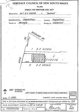
Denfield is a heritage-listed former farm homestead complex, residence, inn and farm and now residence located at Appin Road, St Helens Park in the City of Campbelltown local government area of New South Wales, Australia. It was built in 1837 by John Farley. It was added to the New South Wales State Heritage Register on 2 April 1999.

Macquarie Field House is a heritage-listed former farm, private school and homestead and now residence at Quarter Sessions Road, Macquarie Fields, City of Campbelltown, New South Wales, Australia. It was designed by James Meehan, James Hume and built from 1810 to 1843 by James Meehan ; Mr Burns. It is also known as Macquarie Field House and the Meehan remains; Macquariefield, Macquarie Fields and Macquarie Field. The property is privately owned. It was added to the New South Wales State Heritage Register on 2 April 1999.
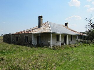
Beulah is a heritage-listed farm at 767 Appin Road, Gilead, New South Wales, an outer suburb of Sydney, Australia in the Macarthur region. It was built from 1835 to 1846 by Cornelius O'Brien, Duncan Cameron, John Kennedy Hume, Ellen Hume; Mansfield Brothers. It is also known as Summer Hill; Summer Hill Estate. The property is privately owned. It was added to the New South Wales State Heritage Register on 2 April 1999.


