Drift Creek (Siletz Bay)

Last updated
Drift Creek
Drift Creek Bridge, Spanning Drift Creek on Drift Creek County Road, Lincoln City vicinity (Lincoln County, Oregon).jpg
Drift Creek Bridge formerly spanned the creek near the Oregon Coast
USA Oregon location map.svg
Red pog.svg
Location of the mouth of Drift Creek in Oregon
Location
CountryUnited States
StateOregon
County Lincoln
Physical characteristics
Sourcenear Stott Mountain
 - location Siuslaw National Forest, Central Oregon Coast Range
 - coordinates 44°56′53″N123°47′10″W / 44.94806°N 123.78611°W / 44.94806; -123.78611 [1]
 - elevation2,767 ft (843 m) [2]
Mouth Siletz River
 - location Siletz Bay
 - coordinates 44°54′40″N124°00′35″W / 44.91111°N 124.00972°W / 44.91111; -124.00972 Coordinates: 44°54′40″N124°00′35″W / 44.91111°N 124.00972°W / 44.91111; -124.00972 [1]
 - elevation7 ft (2.1 m) [1]
Length18 mi (29 km) [3]

Drift Creek is a tributary, about 18 miles (29 km) long, of Siletz Bay in the U.S. state of Oregon. [3] The creek begins near Stott Mountain in the Central Oregon Coast Range in Lincoln County and follows a winding course generally west through the Siuslaw National Forest to enter the bay south of Lincoln City on the Pacific Ocean. It passes under U.S. Route 101 just before reaching the bay. [4]

U.S. state constituent political entity of the United States

In the United States, a state is a constituent political entity, of which there are currently 50. Bound together in a political union, each state holds governmental jurisdiction over a separate and defined geographic territory and shares its sovereignty with the federal government. Due to this shared sovereignty, Americans are citizens both of the federal republic and of the state in which they reside. State citizenship and residency are flexible, and no government approval is required to move between states, except for persons restricted by certain types of court orders. Four states use the term commonwealth rather than state in their full official names.

Oregon State of the United States of America

Oregon is a state in the Pacific Northwest region on the West Coast of the United States. The Columbia River delineates much of Oregon's northern boundary with Washington, while the Snake River delineates much of its eastern boundary with Idaho. The parallel 42° north delineates the southern boundary with California and Nevada. Oregon is one of only three states of the contiguous United States to have a coastline on the Pacific Ocean.

Central Oregon Coast Range

The Central Oregon Coast Range is the middle section of the Oregon Coast Range, in the Pacific Coast Ranges physiographic region, and located in the west-central portion of the state of Oregon, United States roughly between the Salmon River and the Umpqua River and the Willamette Valley and the Pacific Ocean. This approximately 90-mile (140 km) long mountain range contains mountains as high as 4,097 feet for Marys Peak. Portions of the range are inside the Siuslaw National Forest and three wilderness areas exist as well: Drift Creek Wilderness, Cummins Creek Wilderness and Rock Creek Wilderness.

Contents

Named tributaries of Drift Creek from source to mouth are Nelson, Fowler, Barn, Smith, Sampson, Wildcat, and North creeks. Then Quarry, Odell, Bluff, Gordey, and Anderson creeks. [4]

Covered bridge

Until being dismantled and destroyed in 1997 and rebuilt over Bear Creek, a Salmon River tributary to the north and further inland, the Drift Creek Bridge was the state's closest covered bridge to the ocean. [5] Drift Creek Park, managed by Lincoln County, remains open at the former bridge site along South Drift Creek Road. It consists of posted information about the bridge and directions to its new location. [6]

Salmon River (Lincoln County, Oregon) river in Lincoln County, Oregon

The Salmon River flows from the Central Oregon Coast Range to the Pacific Ocean coast of northwest Oregon in the United States. About 24 miles (39 km) long, it begins and ends in Lincoln County but also flows briefly through western Polk and southern Tillamook counties. Much of its course lies within the Siuslaw National Forest.

Drift Creek Bridge former bridge in Lincoln County, Oregon, USA

The Drift Creek Bridge is a covered bridge in Lincoln County in the U.S. state of Oregon. Built in 1914, the structure originally carried Drift Creek County Road over Drift Creek. The creek flows into Siletz Bay of the Pacific Ocean south of Lincoln City.

Covered bridge wooden bridge with protective cover

A covered bridge is a timber-truss bridge with a roof, decking, and siding, which in most covered bridges, create an almost complete enclosure. The purpose of the covering is to protect the wooden structural members from the weather. Uncovered wooden bridges typically have a lifespan of only 20 years because of the effects of rain and sun, but a covered bridge could last 100 years.

Recreation

Hiking

Drift Creek Falls Trail leads 1.5 miles (2.4 km) from the Drift Creek Trailhead along Forest Road 17 to a 240-foot (73 m) suspension bridge overlooking Drift Creek Falls. The waterfall is 75 feet (23 m) high. [7]

Suspension bridge type of bridge

A suspension bridge is a type of bridge in which the deck is hung below suspension cables on vertical suspenders. The first modern examples of this type of bridge were built in the early 1800s. Simple suspension bridges, which lack vertical suspenders, have a long history in many mountainous parts of the world.

Drift Creek Falls is a waterfall formed west of Valley of the Giants, east side of the city of Lincoln City in Lincoln County, Oregon. Access to Drift Creek Falls is located along a trail constructed by the Forest Service in the 1990s and features a 240 foot long suspension bridge crossing Drift Creek.

Waterfall Place where water flows over a vertical drop in the course of a river

A waterfall is an area where water flows over a vertical drop or a series of steep drops in the course of a stream or river. Waterfalls also occur where meltwater drops over the edge of a tabular iceberg or ice shelf.

Fishing

Drift Creek supports populations of cutthroat trout, steelhead, and Chinook salmon. According to Fishing in Oregon, this creek and a Drift Creek in the Alsea River watershed are important in efforts to restore anadromous fish runs in Oregon. The stream has limited road access, and angling in the upper reaches requires hiking via Drift Creek Trail or logging roads. Much of the angling is catch-and-release. [3]

Cutthroat trout species of fish

The cutthroat trout(Oncorhynchus clarkii) is a fish species of the family Salmonidae native to cold-water tributaries of the Pacific Ocean, Rocky Mountains, and Great Basin in North America. As a member of the genus Oncorhynchus, it is one of the Pacific trout, a group that includes the widely distributed rainbow trout. Cutthroat trout are popular gamefish, especially among anglers who enjoy fly fishing. The common name "cutthroat" refers to the distinctive red coloration on the underside of the lower jaw. The specific name clarkii was given to honor explorer William Clark, coleader of the Lewis and Clark Expedition.

Rainbow trout species of trout

The rainbow trout is a trout and species of salmonid native to cold-water tributaries of the Pacific Ocean in Asia and North America. The steelhead is an anadromous (sea-run) form of the coastal rainbow trout(O. m. irideus) or Columbia River redband trout (O. m. gairdneri) that usually returns to fresh water to spawn after living two to three years in the ocean. Freshwater forms that have been introduced into the Great Lakes and migrate into tributaries to spawn are also called steelhead.

Chinook salmon species of fish

The Chinook salmon is the largest species in the Pacific salmon genus Oncorhynchus. The common name refers to the Chinookan peoples. Other vernacular names for the species include king salmon, Quinnat salmon, spring salmon, chrome hog, and Tyee salmon. The scientific species name is based on the Russian common name chavycha (чавыча).

See also

Related Research Articles

Deschutes River (Oregon) river in the United States of America

The Deschutes River in central Oregon is a major tributary of the Columbia River. The river provides much of the drainage on the eastern side of the Cascade Range in Oregon, gathering many of the tributaries that descend from the drier, eastern flank of the mountains. The Deschutes provided an important route to and from the Columbia for Native Americans for thousands of years, and then in the 19th century for pioneers on the Oregon Trail. The river flows mostly through rugged and arid country, and its valley provides a cultural heart for central Oregon. Today the river supplies water for irrigation and is popular in the summer for whitewater rafting and fishing.

Molalla River river in the United States of America

The Molalla River is a 51-mile (82 km) tributary of the Willamette River in the northwestern part of Oregon in the United States. Flowing northwest from the Cascade Range through Table Rock Wilderness, it passes the city of Molalla before entering the larger river near Canby. The Molalla is the largest Willamette tributary unblocked by a dam.

Yaquina River river in Oregon, United States of America

The Yaquina River is a stream, 59 miles (95 km) long, on the Pacific coast of the U.S. state of Oregon. It drains an area of the Central Oregon Coast Range west of the Willamette Valley near Newport.

Siletz River river in the United States of America

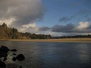
The Siletz River flows about 67 miles (108 km) to the Pacific Ocean through coastal mountains in the U.S. state of Oregon. Formed by the confluence of its north and south forks near Valsetz in Polk County, it winds through the Central Oregon Coast Range. The river, draining a watershed of 373 square miles (970 km2), empties into Siletz Bay, south of Lincoln City in Lincoln County. Although the river travels 67 miles (108 km) in river miles, its winding course begins only about 20 miles (32 km) east of the ocean, and its mouth and source latitudes are almost identical.

Salmon River (Clackamas County, Oregon) river in Oregons Cascade Range

The Salmon River is a 33.5-mile (53.9 km) river in the Cascade Range in the U.S. state of Oregon that drains part of southwestern Mount Hood. The entire length of the river is a protected National Wild and Scenic River. Several portions are in protected wilderness. It is affluent to the Sandy River, a tributary of the Columbia River.

Little White Salmon River river in the United States of America

The Little White Salmon River is a tributary, about 19 miles (31 km) long, of the Columbia River in the U.S. state of Washington. Its headwaters are in the Monte Cristo Range in Gifford Pinchot National Forest. The river flows from this part of the Cascade Range into Drano Lake, an arm of the Bonneville Pool of the Columbia. The river drains a basin of 136 square miles (350 km2) The basin's population was an estimated 513 in 2000.

Winchuck River river in the United States of America

The Winchuck River is a short coastal stream that runs through the Rogue River–Siskiyou National Forest to the Pacific Ocean in the U.S. states of Oregon and California. Flowing generally west from its origin near Elk Mountain, the river enters the sea at Crissey Field State Recreation Site, about 12 mile (0.80 km) north of the Oregon–California border and about 5 miles (8 km) south of Brookings.

Five Rivers (Oregon)

Five Rivers is a tributary of the Alsea River in the U.S. state of Oregon, in Lane, Lincoln, Benton counties. The name Five Rivers refers to the relative importance to the stream of five of its tributaries: Alder, Cougar, Buck, Crab, and Cherry creeks.

Little North Santiam River river in the United States of America

The Little North Santiam River is a 27-mile (43 km) tributary of the North Santiam River in western Oregon in the United States. It drains 113 square miles (290 km2) of the Cascade Range on the eastern side of the Willamette Valley east of Salem.

North Fork Alsea River river in the United States of America

The North Fork Alsea River is a 16-mile (26 km) tributary of the Alsea River in the U.S. state of Oregon. It begins at Klickitat Lake, fed by Klickitat and Lake creeks in the Central Oregon Coast Range, and flows generally south to near Alsea, where it joins the South Fork Alsea River to form the main stem. For most of its course, the North Fork winds through the Siuslaw National Forest in Lincoln County and then Benton County. It passes under Oregon Route 34 northeast of Alsea.

North Fork Smith River (Umpqua River tributary) river in the United States of America

The North Fork Smith River is a 34-mile (55 km) tributary of the Smith River in Douglas County in the U.S. state of Oregon. It begins in the Central Oregon Coast Range near Roman Nose Mountain and flows generally southwest to meet the larger river 16 miles (26 km) from its confluence with the Umpqua River at Reedsport. The entire course of the North Fork lies within the Siuslaw National Forest.

Deadwood Creek (Oregon) river in the United States of America

Deadwood Creek is a tributary of Lake Creek in the Siuslaw River basin in Lane County in the U.S. state of Oregon. Beginning near Taylor Butte in the Central Oregon Coast Range, it meanders generally southwest through the Siuslaw National Forest to meet the larger creek at the rural community of Deadwood. This is 5 miles (8 km) from Lake Creek's confluence with the river near Swisshome and 34 miles (55 km) by water from the Siuslaw River's mouth on the Pacific Ocean at Florence.

Lake Creek (Siuslaw River)

Lake Creek is a major tributary of the Siuslaw River in Lane County in the U.S. state of Oregon. On average, the 40-mile (64 km) long creek contributes about a third of the lower Siuslaw's water volume.

Fall Creek (Middle Fork Willamette River)

Fall Creek is a 34-mile (55 km) tributary of the Middle Fork Willamette River in Lane County in the U.S. state of Oregon. Beginning in the Cascade Range, the creek flows generally west through the Willamette National Forest to enter the Middle Fork upstream of Jasper, southeast of Springfield and Eugene.

Middle Fork Coquille River river in the United States of America

The Middle Fork Coquille River is a tributary, about 40 miles (64 km) long, of the South Fork Coquille River in the U.S. state of Oregon. It begins near Camas Mountain in Douglas County in the Southern Oregon Coast Range. It flows generally south, bypassing the community of Camas Valley while passing through the valley of the same name, then curves west and north to Remote in Coos County. The Middle Fork then flows generally west, passes by the small community of Bridge, and meets the South Fork near Myrtle Point. The confluence with the South Fork is 41 miles (66 km) by water to where the main stem of the Coquille River enters the Pacific Ocean at Bandon.

Bear Creek (Lincoln County, Oregon)

Bear Creek is a tributary of the Salmon River in the Central Oregon Coast Range in the United States. It begins in the Siuslaw National Forest and flows generally northwest through Lincoln County to meet the river between Rose Lodge and Otis. Named tributaries from source to mouth are McMullen, Tarry, Southman, and Morton creeks.

Rocky Creek (Oregon) short coastal stream in Lincoln County in the U.S. state of Oregon

Rocky Creek is a short coastal stream in Lincoln County in the U.S. state of Oregon. It begins near the western extremities of the Central Oregon Coast Range and flows generally west to the ocean south of Depot Bay and north of Otter Rock. It has no named tributaries.

Cavitt Creek river in the United States of America

Cavitt Creek is a tributary of the Little River in Douglas County in the U.S. state of Oregon. From its source near Red Butte, the creek flows generally west then north through the Umpqua National Forest of the Cascade Range before entering the river about 1.5 miles (2.4 km) upstream of the rural community of Peel and 7 miles (11 km) above the Little River's mouth on the North Umpqua River.

References

  1. 1 2 3 "Drift Creek". Geographic Names Information System. United States Geological Survey. November 28, 1980. Retrieved January 23, 2016.
  2. Source elevation derived from Google Earth search using GNIS source coordinates.
  3. 1 2 3 Sheehan, Madelynne Diness. Fishing in Oregon: The Complete Oregon Fishing Guide (10th ed.). Scappoose, Oregon: Flying Pencil Publications. pp. 13–14. ISBN   0-916473-15-5.
  4. 1 2 "United States Topographic Map". United States Geological Survey. Retrieved January 23, 2016 via Acme Mapper.
  5. "Drift Creek (Bear Creek) Covered Bridge" (PDF). Oregon Department of Transportation. Retrieved January 24, 2016.
  6. "Drift Creek Park". Lincoln County, Oregon. Retrieved January 24, 2016.
  7. "Drift Creek Falls Trail #1378". United States Forest Service. Retrieved January 24, 2016.