Driver, Virginia

Last updated

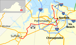
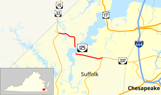
Driver is a neighborhood in the independent city of Suffolk, Virginia, United States. It is located at the junction of State Route 337, State Route 125, and State Route 627.

An independent city or independent town is a city or town that does not form part of another general-purpose local government entity.

Suffolk, Virginia Independent city in Virginia, United States

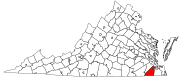
Suffolk is an independent city in the Commonwealth of Virginia. As of the 2017 census, the estimated population was 90,237. It is the largest city in Virginia by boundary land area as well as the 14th largest in the country.

Virginia State of the United States of America

Virginia, officially the Commonwealth of Virginia, is a state in the Southeastern and Mid-Atlantic regions of the United States located between the Atlantic Coast and the Appalachian Mountains. Virginia is nicknamed the "Old Dominion" due to its status as the first English colonial possession established in mainland North America and "Mother of Presidents" because eight U.S. presidents were born there, more than any other state. The geography and climate of the Commonwealth are shaped by the Blue Ridge Mountains and the Chesapeake Bay, which provide habitat for much of its flora and fauna. The capital of the Commonwealth is Richmond; Virginia Beach is the most populous city, and Fairfax County is the most populous political subdivision. The Commonwealth's estimated population as of 2018 is over 8.5 million.

Contents

Originally named Persimmon Orchard, Driver was once located on the now-abandoned Atlantic Coast Line Railroad's line in the former Nansemond County between the former town of Suffolk and the City of Portsmouth, which was itself was located in the former Norfolk County.

Atlantic Coast Line Railroad defunct American Class I railroad

The Atlantic Coast Line Railroad is a former U. S. Class I railroad from 1900 until 1967, when it merged with long-time rival Seaboard Air Line Railroad to form the Seaboard Coast Line Railroad. Much of the original ACL network has been part of CSX Transportation since 1986.

Nansemond County, Virginia extinct locality that was located in Virginia Colony and the Commonwealth of Virginia

Nansemond is an extinct locality that was located in Virginia Colony and the Commonwealth of Virginia in the United States, from 1646 until 1974. It was Nansemond County until 1972, and the independent city of Nansemond from 1972 to 1974. It is now part of the independent city of Suffolk.

Portsmouth, Virginia Independent city in Virginia, United States

Portsmouth is an independent city in the Commonwealth of Virginia. As of the 2010 census, the population was 95,535. It is part of the Hampton Roads metropolitan area.

Through traffic in Driver formerly used the now closed Kings Highway Bridge to cross the Nansemond River on State Route 125, known as the "Kings Highway." The drawbridge, opened in 1928, was deemed unsafe and closed to traffic in March 2005 by the Virginia Department of Transportation.

Kings Highway Bridge was located on the Nansemond River in the independent city of Suffolk, Virginia, United States. Built in 1928, it carried traffic on the Kings Highway, also known as State Route 125, for over 75 years.

Nansemond River river in the United States of America

The Nansemond River is a 19.8-mile-long (31.9 km) tributary of the James River in Virginia in the United States. English settlers named the river for the Nansemond tribe of Native Americans, who then inhabited the area. The river begins at the outlet of Lake Meade north of downtown Suffolk, historically marking the northern boundary of the city. The Nansemond River Light once marked the river's confluence with the James.

Drawbridge type of movable bridge

A drawbridge or draw-bridge is a type of movable bridge typically at the entrance to a castle or tower surrounded by a moat. In some forms of English, including American English, the word drawbridge commonly refers to all types of movable bridges, such as bascule bridges, vertical-lift bridges and swing bridges, but this article concerns the narrower, more historical definition of the term.

In modern times, as the Hampton Roads area has become largely urbanized all around it, it has been said that Driver is a town "suspended in time." Driver is known in Suffolk for its Driver Variety Store, which is styled as an old time general store, and its annual Driver Days festival.

April 2008 Suffolk tornado

Aerial view of tornado damage in Suffolk on April 28, 2008 (NWS Wakefield, Virginia) Suffolk Tornado Damage.JPG
Aerial view of tornado damage in Suffolk on April 28, 2008 (NWS Wakefield, Virginia)

After 4:00 PM EST on April 28, 2008, a tornado touched down multiple times causing damage and leaving over 200 injured in Suffolk along a path which passed north and west of the downtown area striking near Sentara Obici Hospital and in Driver. The storm seriously damaged over 120 homes and 12 businesses. The subdivisions of Burnett's Mill and Hillpoint Farms were damaged particularly hard, as well as several of the older historic structures in Driver. However, near Driver, large radio and television broadcast towers located in an antenna farm serving most of Hampton Roads were spared serious damage.

Tornado violently rotating column of air that is in contact with both the earths surface and a cumulonimbus cloud in the air

A tornado is a rapidly rotating column of air that is in contact with both the surface of the Earth and a cumulonimbus cloud or, in rare cases, the base of a cumulus cloud. The windstorm is often referred to as a twister, whirlwind or cyclone, although the word cyclone is used in meteorology to name a weather system with a low-pressure area in the center around which winds blow counterclockwise in the Northern Hemisphere and clockwise in the Southern. Tornadoes come in many shapes and sizes, and they are often visible in the form of a condensation funnel originating from the base of a cumulonimbus cloud, with a cloud of rotating debris and dust beneath it. Most tornadoes have wind speeds less than 110 miles per hour (180 km/h), are about 250 feet (80 m) across, and travel a few miles before dissipating. The most extreme tornadoes can attain wind speeds of more than 300 miles per hour (480 km/h), are more than two miles (3 km) in diameter, and stay on the ground for dozens of miles.

Antenna farm

Antenna farm or satellite dish farm or just dish farm are terms used to describe an area dedicated to television or radio telecommunications transmitting or receiving antenna equipment, such as C, Ku or Ka band satellite dish antennas, UHF/VHF/AM/FM transmitter towers or mobile cell towers. The history of the term "antenna farm" is uncertain, but it dates to at least the 1950s.

Governor Timothy Kaine declared a state of emergency and directed state agencies to assist the recovery and cleanup efforts.

Climate

The climate in this area is characterized by hot, humid summers and generally mild to cool winters. According to the Köppen Climate Classification system, Driver has a humid subtropical climate, abbreviated "Cfa" on climate maps. [1]

Humid subtropical climate category in the Köppen climate classification system

A humid subtropical climate is a zone of climate characterized by hot and humid summers, and mild winters. These climates normally lie on the southeast side of all continents, generally between latitudes 25° and 40° and are located poleward from adjacent tropical climates. While many subtropical climates tend to be located at or near coastal locations, in some cases they extend inland, most notably in China and the United States, where they exhibit more pronounced seasonal variations and sharper contrasts between summer and winter, as part of a gradient between the more tropical climates of the southern coasts of these countries and the more continental climates of China and the United States’ northern and central regions.

See also

Coordinates: 36°49′24″N76°30′09″W / 36.82333°N 76.50250°W / 36.82333; -76.50250 [2]

Related Research Articles

Chesapeake, Virginia Independent city in Virginia

Chesapeake is an independent city in the Commonwealth of Virginia. As of the 2010 census, the population was 222,209; in 2013, the population was estimated to be 232,977, making it the third-most populous city in Virginia.

Monitor–Merrimac Memorial Bridge–Tunnel bridge in United States of America

Monitor–Merrimac Memorial Bridge–Tunnel (MMMBT) is the 4.6 mile-long (7.4 km) Hampton Roads crossing for Interstate 664 in the southeastern portion of Virginia in the United States. It is a four-lane bridge–tunnel composed of bridges, trestles, man-made islands, and tunnels under a portion of the Hampton Roads harbor where the mouths of the James, Nansemond, and Elizabeth Rivers come together.

South Hampton Roads

South Hampton Roads is a region located in the extreme southeastern portion of Virginia's Tidewater region in the United States with a total population of 1,191,937. It is part of the Virginia Beach-Norfolk-Newport News, VA-NC MSA, which itself has a population of 1,724,876.

James River Bridge

The James River Bridge is a four-lane divided highway lift bridge across the James River in the Commonwealth of Virginia. Owned and operated by the Virginia Department of Transportation, it carries U.S. Route 17 (US 17), US 258, and State Route 32 across the river near its mouth at Hampton Roads. The bridge connects Newport News on the Virginia Peninsula with Isle of Wight County in the South Hampton Roads region, and is the easternmost such crossing without a tunnel component.

The area around Suffolk, Virginia, which is now an independent city in the Hampton Roads region in the southeastern part of the state, was originally inhabited by Native Americans. At the time of European contact, the Nansemonds lived along the river later known by the same name. Suffolk was first explored by the English settlers based at Jamestown, not long after their arrival. They sought a means to survive the inhospitable environment at Jamestown Island.

Virginia State Route 10 highway in Virginia

State Route 10 is a primary state highway in the U.S. state of Virginia. The state highway runs 93.58 miles (150.60 km) from U.S. Route 360 in Richmond east to SR 337 in Suffolk. SR 10 is a major suburban highway through Chesterfield County between the Southside of Richmond and Hopewell. Between Hopewell and Smithfield, which is served by SR 10 Business, the state highway passes through rural Prince George, Surry, and Isle of Wight counties, following the route of an old stagecoach road through an area that features many of the preserved James River plantations. SR 10 runs concurrently with US 258 and SR 32 between Smithfield and Suffolk.

Virginia State Route 32 highway in Virginia

State Route 32 is a primary state highway in the U.S. state of Virginia. The state highway runs 38.89 miles (62.59 km) from the North Carolina state line in Suffolk north to U.S. Route 17, US 258, and SR 143 in Newport News. The southernmost part of SR 32 connects Suffolk with the Albemarle Region of North Carolina via North Carolina Highway 32. The remainder of SR 32 runs concurrently with at least one other state or U.S. Highway between Suffolk and Newport News, including US 13, SR 10, US 258, and US 17. The last two highways run together with SR 32 on the James River Bridge.

The state highway system of the U.S. state of Virginia is a network of roads maintained by the Virginia Department of Transportation (VDOT). As of 2006, the VDOT maintains 57,867 miles (93,128 km) of state highways, making it the third-largest system in the United States.

Virginia State Route 337 highway in Virginia

State Route 337 is a primary state highway in the South Hampton Roads area of the U.S. state of Virginia. It runs east from Suffolk to Portsmouth, where it crosses Jordan Bridge. It continues on the east side of the Southern Branch Elizabeth River in the South Norfolk neighborhood of Chesapeake. There it turns north, through Norfolk, crossing the Berkley Bridge into downtown, and ending at the Naval Station Norfolk at Sewell's Point. Most of its length was formed when other highways were rerouted: U.S. Route 460 from Suffolk to South Norfolk, SR 170 from South Norfolk to downtown Norfolk, and US 17 from downtown Norfolk to Sewell's Point. SR 337 is the only numbered highway to cross all three Branches of the Elizabeth River. It crosses the Western Branch as Portsmouth Boulevard at the Hodges Ferry Bridge, the Southern Branch on the Jordan Bridge, and the Eastern Branch on the Berkley Bridge. The Berkley Bridge is a drawbridge. SR 337 also crosses the Lafayette River in the city of Norfolk.

Holland, Virginia was an incorporated town in the southwestern section of Nansemond County, Virginia. Since 1974, it has been a community in the independent city of Suffolk, Virginia following a political consolidation which formed Virginia's largest city in geographic area.

U.S. Route 13 is a north–south U.S. highway established in 1926 that runs for 517 miles (832 km) from Interstate 95 just north of Fayetteville, North Carolina to U.S. Route 1 in Falls Township, Pennsylvania, a northeastern suburb of Philadelphia. In the U.S. state of Virginia, US 13 runs north–south through the Hampton Roads and Eastern Shore regions of the state, using the Chesapeake Bay Bridge–Tunnel to get between the two. In the Hampton Roads area, it uses Military Highway to bypass the city centers. It is most usually a four-lane highway, sometimes up to freeway or expressway standards with controlled access.

Virginia State Route 125 highway in Virginia

State Route 125 is a primary state highway in the U.S. state of Virginia. Known as Kings Highway, the state highway has two sections that run a total of 5.73 miles (9.22 km) from SR 10 and SR 32 at Chuckatuck east to SR 337 at Driver within the independent city of Suffolk. SR 125 consists of a 2.69-mile (4.33 km) western section and a 3.04-mile (4.89 km) eastern section separated by a gap at the Nansemond River. This gap arose when the Kings Highway Bridge across the river was removed in 2008.

Byrd Road Act

The Byrd Road Act was an Act of Assembly passed in February, 1932 by the Virginia General Assembly. Named for former Governor Harry F. Byrd, the legislation was originally presented as measure to relieve the financial pressures of the Great Depression upon the counties, as the state offered to take over responsibility and control of most county roads, creating the Virginia Secondary Roads System.

Whaleyville is a neighborhood of Suffolk, Virginia, United States. It was formerly an incorporated town located in southern Nansemond County, Virginia. Whaleyville is located midway between the former county seat at downtown Suffolk and the North Carolina border along U.S. Route 13.

Pughsville is a community in Virginia. It was part of Nansemond County, Virginia which ceased to exist when it was merged into Suffolk, Virginia in the 1970s. The Pughsville community is now in the northern part of Suffolk, Virginia along the border with Chesapeake, Virginia.

References