Related Research Articles

Lifford is the county town of County Donegal, Ireland, the administrative centre of the county and the seat of Donegal County Council, although the town of Letterkenny is often mistaken as holding this role.
Donegal is a town in County Donegal, Ireland. The name was also historically spelt 'Dunnagall'. Although Donegal gave its name to the county, now Lifford is the county town. From the 15th until the early 17th century, Donegal was the 'capital' of Tyrconnell, a Gaelic kingdom controlled by the O'Donnell dynasty of the Northern Uí Néill.
The River Foyle is a river in west Ulster in the northwest of the island of Ireland, which flows from the confluence of the rivers Finn and Mourne at the towns of Lifford in County Donegal, Republic of Ireland, and Strabane in County Tyrone, Northern Ireland. From here it flows to the city of Derry, where it discharges into Lough Foyle and, ultimately, the Atlantic Ocean. The total length of the River Foyle is 32 km (20 mi). The river separates part of County Donegal from parts of both County Londonderry and County Tyrone. The district of County Donegal that borders the western bank of the River Foyle is traditionally known as the Laggan. This district includes the villages of St. Johnston and Carrigans, both of which are nestled on the banks of the River.

Fintona, is a village and townland in County Tyrone, Northern Ireland. Its population at the 2011 Census was 1,164.

Ballintra is a village in the parish of Drumholm in the south of County Donegal, Ireland, just off the N15 road between Donegal town and Ballyshannon. Ballintra lies on the northern bank of the Blackwater river. The river rises in the hills that lie inland from the town, and flows through a number of small lakes before spilling over a small waterfall in a gorge behind the village.

The River Swilly is a river in County Donegal, Ireland, which flows in an eastern direction through Letterkenny. Letterkenny, the largest town in County Donegal, is built on the river and became the first crossing point on the river in the 17th century.
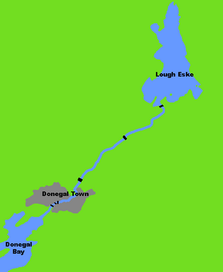
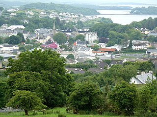
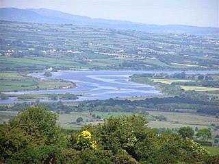
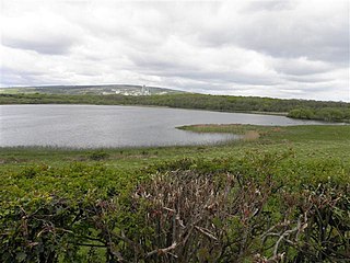
The River Eske is a river in County Donegal, Ireland. It begins at Lough Eske in the southeast of the county before flowing mainly westwards to the town of Donegal and into the Atlantic Ocean via Donegal Bay.

Banagh is a historic barony in County Donegal in Ireland. Patrick Weston Joyce said the name Banagh came from Enna Bogaine, son of Conall Gulban, son of Niall of the Nine Hostages. It was created along with Boylagh when the former barony of Boylagh and Banagh was split in 1791 by an Act of the Parliament of Ireland.
Cavanagh is a townland in the civil parish of Tomregan, County Cavan, Ireland. It lies within the former barony of Tullyhaw.

Carrowmore, County Cavan is a townland in the Parish of Tomregan, Barony of Tullyhaw, County Cavan, Ireland.
Annagh is a townland in the Parish of Tomregan, Barony of Tullyhaw, County Cavan, Ireland.
Binkeeragh is a townland in the civil parish of Kinawley, barony of Tullyhaw, County Cavan, Ireland.

The R267 road is a regional road in County Donegal, Ireland. The road links Donegal Town with the N15, a road which runs around the eastern and south-eastern edge of Donegal Town. The N15 forms part of the main road between Derry and Sligo Town. The R267, parts of which are known as the Derry Road or the Ballybofey Road within Donegal Town, crosses the Drumenny Burn between The Northern Garage and the District Hospital, near where the burn enters the River Eske.T he road is 5.6 km (3.5 mi) long.
The Burn Dale is a burn or small river in the east of County Donegal in Ulster, the northern province in Ireland. The burn is also known in English as the Dale Burn, the Burn Deele, the Burndale River, the Deele River or the River Deele. In the Ulster Scots dialect, a 'burn' is a stream or small river.

The Finn River, also known as the River Finn, is a small river that flows through parts of County Fermanagh and parts of County Monaghan in the south of Ulster, the northern province in Ireland. In certain places, the river forms part of the boundary between County Fermanagh, which is part of Northern Ireland, and County Monaghan, which is part of the Republic of Ireland. Two very short stretches of the river, just north of Redhills and at Castle Saunderson, near Belturbet, also form part of the boundary between County Fermanagh and County Cavan. This means that some stretches of the river form part of the border between Northern Ireland and the Republic of Ireland, these short stretches also forming part of the external border of the European Union.
The Cronaniv Burn is a burn or small river that flows through the Poisoned Glen in Gaoth Dobhair, a district in the north-west of County Donegal in Ulster, the northern province in Ireland. In the Ulster Scots dialect, a 'burn' is a stream or small river.
The Clady River is a small river in Gweedore, a district in the north-west of County Donegal in Ulster, the northern province in Ireland. The river flows entirely within the Civil Parish of Tullaghobegly.
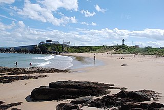
Shrove is a coastal hamlet and townland in Inishowen in the north of County Donegal in the north-west of Ulster, the northern province in Ireland. The hamlet is located a short distance to the north of Greencastle in the north-east of Inishowen, a peninsula on the north coast of Ireland. The name of both the hamlet and the townland is also sometimes written as Shroove, and is sometimes written as Stroove by some government bodies.
Largy Waterfall is a small waterfall located in the south-west of County Donegal in Ulster, the northern province in Ireland. The coastal waterfall is in Largy, a hamlet just west of Fintra Strand, a few miles west of Killybegs. The waterfall is often popularly known as County Donegal's Secret Waterfall or South Donegal's Secret Waterfall.
Wattlebridge, sometimes written as Wattle Bridge, is a small hamlet in the south-south-east of County Fermanagh in Northern Ireland. The hamlet is located almost 3½ miles south of the village of Newtownbutler. The hamlet is in a region known unofficially as South Ulster.
References
- 1 2 3 4 Discovery Series Sheet 11 (4th Edition). Ordnance Survey of Ireland (O.S.I.), Dublin, 2012.
- 1 2 3 4 Angélique Day and Patrick McWilliams (Editors), Ordnance Survey Memoirs of Ireland Volume 39 - Parishes of County Donegal II, 1835-6: Mid, West and South Donegal, p. 44 and p. 54. The Institute of Irish Studies, The Queen's University of Belfast, Belfast, 1997 (in association with the Royal Irish Academy).
- ↑ Patrick McKay, A Dictionary of Ulster Place-Names, p. 31 (see entries for 'Burnfoot' and 'Burntollet River') and p. 150. The Institute of Irish Studies, The Queen's University of Belfast, Belfast, 1999.
- ↑ Drumenny Upper Townland, Co. Donegal. https://www.townlands.ie/donegal/tirhugh/donegal/tullynaught/drumenny-upper/
- ↑ Drummenny Middle Townland, Co. Donegal. https://www.townlands.ie/donegal/tirhugh/donegal/tullynaught/drummenny-middle/
- 1 2 Drummenny Lower Townland, Co. Donegal. https://www.townlands.ie/donegal/tirhugh/donegal/tullynaught/drummenny-lower/
- ↑ Civil Parish of Donegal, Co. Donegal. https://www.townlands.ie/donegal/donegal2/
- ↑ Clogher Hill. https://www.townlands.ie/donegal/tirhugh/donegal/clogher/clogher/clogher-hill/
- ↑ Straness Townland, Co. Donegal. https://www.townlands.ie/donegal/tirhugh/drumhome/tullynaught/straness/
- ↑ Barnesyneilly Townland, Co. Donegal. https://www.townlands.ie/donegal/tirhugh/drumhome/tullynaught/barnesyneilly/
- ↑ N.B.C.M.S.O.: Straness Wind Farm. https://www.localgov.ie/en/bcms/notice/straness-wind-farm