
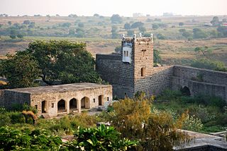
Nizamabad is also known as Induru is a city in the Indian state of Telangana. Nizamabad is a major urban agglomeration and third largest city in the state. It is governed by municipal corporation and is the headquarters of the Nizamabad district. Although previously part of Hyderabad State and then Andhra Pradesh state, Nizamabad became a part of the newly formed state of Telangana by the Andhra Pradesh Reorganisation Act, 2014.It is located about 186 kilometres (116 mi) north of the state capital, Hyderabad.

Azamgarh district is one of the three districts of Azamgarh division in the Indian state of Uttar Pradesh.
Nanded district is a district of Maharashtra state in central India. The city of Nanded is the district headquarters.

Nizamabad district is a district located in the north-western region of the Indian state of Telangana. The city of Nizamabad is the district headquarters. The district share boundaries with Jagtial, Sircilla, Nirmal, Kamareddy districts and with Nanded district of the state boundary of Maharashtra.
Nizamabad is a town and a nagar panchayat in Azamgarh district in the Indian state of Uttar Pradesh. The city is well known for its black clay pottery.
Sukhmalpur Nizamabad is a census town in Firozabad district in the Indian state of Uttar Pradesh.
Armoor is a city in a Indian state Telangana in Nizamabad district, it is fastest growing city in the state and second biggest developed city in nizamabad district after nizamabad city, in the state of Telangana in India. Armoor is situated on NH 7 and NH 63. In earlier days, it was called Navanathapuram since it has nine mountains around the city Armoor is a variation of it.Armoor is one of fastest growing city in the Telangana state

Navipet is a Mandal in Nizamabad district in the state of Telangana in India Navipet is top mandal in Nizamabad district Which has good market value for crops and small revenue business. Navipet lies on Nizamabad Bhainsa main road. Navipet is famous for weekly goats market.
Bheemgal is a town in the Nizamabad district, in the state of Telangana in India, 52.2 km from the main city of the District, Nizamabad and 172 km from the State Capital Hyderabad.
Lingampet is a panchayat village in Kamareddy District in the state of Telangana in India.
Ankapur is a village in Armoor mandal, Nizamabad district of the Indian state of Telangana. It comes under the Armur town which is like five kilometers away from this village. This village is considered one of the Model Villages in the country. It is recognized as a Model Village by the ICAR, ICRISAT and the International Rice Research Institute.

Bijapur District, formerly known as Birjapur, is one of the 27 districts of the state of Chhattisgarh in central India. It is one of the two new districts created on May 11, 2007. As of 2011 it is the second least populous district of Chhattisgarh, after Narayanpur. It is the second-least literate district in India, with a literacy rate of at 41.58%, according to the 2011 census.
Donkeshwar is a village in Nandipet Mandal in Nizamabad district in the Indian state of Telangana.
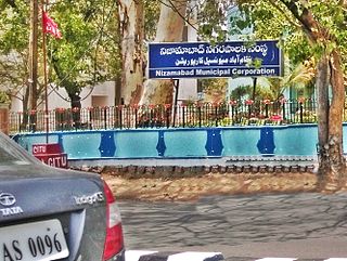
The Nizamabad Municipal Corporation(MCN or NMC) is the local governing body, administering the city of Nizamabad in the Indian state of Telangana. It is the third largest city in the state after Hyderabad and Warangal. As of 2011 census, the municipal corporation had a population of 310,467. The municipal corporation consists of democratically elected members, is headed by a mayor and administers the city's governance, infrastructure and administration.
Nizamabad mandal is one of the 27 mandals within Nizamabad District in the Indian state of Telangana. It is located in the revenue division of Nizamabad, while the headquarters are located in the city of the same name. The mandal is bordered by those of Mosra, Chandur, Yedpalle, Navipet, Makloor, Gandhari, and Dichpalle.

Nirmal district is a district located in the northern region of the Indian state of Telangana. The district headquarters is located in the town of Nirmal. It borders the Telangana districts of Adilabad, Nizamabad, Mancherial, Asifabad, Jagtial districts as well as Nanded district of the state Maharashtra.

Kamareddy district is a district located in the northern region of the Indian state of Telangana. The district shares boundaries with Medak, Nizamabad, Sangareddy, Siddipet and Rajanna Sircilla districts and with the state boundary of Maharashtra and Karnataka.
Jagtial district is a district located in the northern region of the Indian state of Telangana. Its headquarters is Jagtial. The district shares boundaries with Nirmal, Mancherial, Karimnagar, Peddapalli, Sircilla and Nizamabad districts.
