The District Municipality of Muskoka, more generally referred to as the District of Muskoka or Muskoka, is a regional municipality in Central Ontario, Canada. Muskoka extends from Georgian Bay in the west, to the northern tip of Lake Couchiching in the south, to the western border of Algonquin Provincial Park in the east. A two-hour drive north of Toronto, Muskoka spans 6,475 km2 (2,500 sq mi). Muskoka has some 1,600 lakes, making it a popular cottaging destination.
The Archipelago is a township in central Ontario, Canada, along the Georgian Bay in the Parry Sound District.

Restoule is a community and designated place in geographic Patterson Township in the Centre Unorganized Part of Parry Sound District in Central Ontario, Canada. It is situated on the Restoule River between Commanda Lake, and Restoule Lake and is part of the Almaguin Highlands region.

The English River is a river in Kenora District and Thunder Bay District in Northwestern Ontario, Canada. It flows through Lac Seul to join the Winnipeg River at Tetu Lake as a right tributary. The river is in the Hudson Bay drainage basin, is 615 kilometres (382 mi) long and has a drainage basin of 52,300 square kilometres (20,200 sq mi). Although there are several hydroelectric plants on this river, the English River upstream of Minnitaki Lake is notable as one of the few large river systems in northwestern Ontario with a natural flow and without any upstream source of pollution. It is the fourth longest river entirely in Ontario.

The Moon River is a river in the municipalities of Georgian Bay and Muskoka Lakes, District Municipality of Muskoka in Central Ontario, Canada. It flows from Lake Muskoka at the community of Bala to Georgian Bay, Lake Huron, south of Parry Sound. The name of the river is thought to be derived from its Ojibwa name moonz-ziibi, which means "moose river".
King's Highway 69, commonly referred to as Highway 69, is a provincially maintained north–south highway in the central portion of the Canadian province of Ontario. In conjunction with Highway 400, it links Toronto with the city of Greater Sudbury at Highway 17, via Parry Sound. It is part of the Trans-Canada Highway and the National Highway System. From its southern terminus of Highway 559 at Carling, Highway 69 begins as Highway 400 narrows from a four-laned freeway to a two lane highway. It travels northerly for approximately 68 kilometres (42 mi) to south of the French River before widening back to a divided four lane freeway for approximately 64 kilometres (40 mi) into Sudbury. The final 6 kilometres (3.7 mi) of the route, connecting to Highway 17, is a five lane arterial road that will be converted to freeway as the final phase of the four-laning.
Tara is an unincorporated community in the municipality of Arran–Elderslie, Bruce County, in southwestern Ontario, Canada. It is a designated place and had 1,037 residents and 458 dwellings as of the 2011 census. Tara is in geographic Arran Township and is located on the Sauble River. It has an area of 2.39 square kilometres (0.92 sq mi) and an urban area that covers 63.5 square kilometres (24.5 sq mi).

Nipissing is an incorporated (political) township in Parry Sound District in Central Ontario, Canada. It is on Lake Nipissing and is part of the Almaguin Highlands region. Nipissing was surveyed between 1874 and 1881, and was incorporated in 1888. Among the first settlers in the area were the Chapman and Beatty families. Nipissing Township annexed Gurd Township in 1970. The township also contains a community named Nipissing, which is located on the South River near Chapman's Landing, on the South Bay of Lake Nipissing. The township administrative offices are located in Nipissing.
King's Highway 124, commonly known as Highway 124, is a provincially maintained highway in the Canadian province of Ontario. The highway connects Highway 400 in Parry Sound with Highway 11 in Sundridge, a distance of 91.2 km (56.7 mi), including a 15.4 km (9.6 mi) concurrency with Highway 520. It is one of several highways in Central Ontario to provide this connection through the Muskoka and Parry Sound region, and the northernmost provincial highway to do so south of Highway 17.

Secondary Highway 520, commonly referred to as Highway 520, is a provincially maintained highway in the Canadian province of Ontario. The highway is 67.9 kilometres (42.2 mi) in length, connecting several small communities in Parry Sound District with Highway 124 and Highway 11.

Whitestone is a municipality in the Canadian province of Ontario, as well as the name of a community within the municipality.
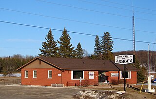
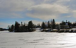
Armour is a township municipality in the Canadian province of Ontario.
Wahwashkesh Lake is a lake in Whitestone, Parry Sound District, Ontario, Canada, and is the largest lake in Parry Sound District, with a surface area of 1,721 hectares and over 106 km of shoreline. Approximately 30% of the shoreline property is Crown Land. The lake has two distinct basins: (1) the north basin or Top Lake is the smaller of the two, and (2) the south basin is the Big Lake. Wahwashkesh is part of the Magnetawan River system, and the lake is renowned for an extremely severe spring freshet with the lake levels often rising 3 to 4 meters above the concrete weir at the outlet of the river.

South Algonquin is a township municipality in Nipissing District, Ontario, Canada. Located south of Algonquin Provincial Park, it is the sole populated portion of the district that lies south of the traditional dividing line between Northern Ontario and Southern Ontario and is closer connected to Renfrew County as opposed to the core portions of Nipissing District.
King's Highway 141, commonly referred to as Highway 141, is a provincially maintained highway in the Canadian province of Ontario. Its western terminus is at Highway 400 south of Horseshoe Lake in Seguin Township while its eastern terminus is at Highway 11 near Port Sydney. The route was designated in 1974 when Highway 532 was renumbered and upgraded from a secondary highway to a King's Highway. The route has remained generally unchanged since, though it was extended by several kilometres on October 7, 2003 when Highway 400 was extended north of Mactier.
King's Highway 169, commonly referred to as Highway 169, was a provincially maintained highway in the Canadian province of Ontario. The highway connected Highway 12 at Brechin, southeast of Orillia, with Highway 69 at Foot's Bay. The 91.40 km (56.79 mi) route included an 18.20 km (11.31 mi) concurrency with Highway 11 between Washago and Gravenhurst. Located within Simcoe County and the District Municipality of Muskoka, the highway also provided access to the community of Bala.
Shawanaga lake is a lake located in the Municipality of Whitestone, District of Parry Sound, Ontario, Canada.

The Almaguin Highlands Region in Ontario, Canada, covers approximately 5,200 km2 (2,000 sq mi) comprising the eastern half of Parry Sound District. It is bounded by Muskoka in the south, and by Lake Nipissing and Nipissing District in the north. The eastern edge abuts the western boundary of Algonquin Provincial Park, whereas the western boundary of the Almaguin Highlands is generally regarded to be the mid east-west point of Parry Sound District. Originally derived from the words Algonquin, Magnetawan, and Seguin. the name Almaguin is now used to describe the marketing region of East Parry Sound.
Shawanaga is an unincorporated geographic township in the Unorganized Centre Part of Parry Sound District in central Ontario, Canada.
Peters Lake is a lake in the municipality of Kearney, Parry Sound District in central Ontario, Canada. It is in the Lake Huron drainage basin.