
West Godavari district is one of the twenty six districts in the andhra region of the Indian state of Andhra Pradesh. The administrative headquarters of the district is situated at Bhimavaram. As of 2011 census of India, the district has an area of 7,742 km2 (2,989 sq mi) and a population of 1,779,935 It is bounded by Eluru District to the north, Krishna district and Bay of Bengal to the south, East Godavari district to the east, and Eluru District, Kolleru Lake and Upputeru Drain to the west.
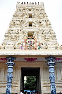
Dwaraka Tirumala is a census town in Eluru district of the Indian state of Andhra Pradesh. It is located in Dwaraka Tirumala mandal of Jangareddygudem revenue division. The Venkateswara Temple is a pilgrimage center for hindus, which is the abode of Lord Venkateswara. This is often referred by the locals as Chinna Tirupati, meaning mini Tirupati.
Kamavarapukota is a village in Eluru district of the Indian state of Andhra Pradesh. The nearest railway station is at Sitampet.
Eluru mandal is one of the 28 mandals in Eluru district of the Indian state of Andhra Pradesh. It is administered under Eluru revenue division and its headquarters are located at Eluru city. The mandal is bounded by Pedapadu mandal, Pedavegi mandal, Denduluru mandal, Bhimadole mandal and it also borders Krishna district.
Tangellamudi is a census town in Eluru district of the Indian state of Andhra Pradesh. It is in Eluru mandal of Eluru revenue division. The town is a constituent of Eluru urban agglomeration. The nearest railway station is in Powerpet and is 1.5 km.
Kamavarapukota is a mandal in Eluru district in the state of Andhra Pradesh in India.
Polavaram mandal is one of the 28 mandals in Eluru district of the Indian state of Andhra Pradesh. It is under the administration of Jangareddigudem revenue division and the headquarters are located at Polavaram. The mandal lies on the banks of Godavari River which separates it from East Godavari district and is bounded by Gopalapuram and Buttayagudem mandals.
Jangareddygudem is a mandal in Eluru district in the state of Andhra Pradesh in India.
Ganapavaram mandal is one of the 28 mandals in Eluru district of the Indian state of Andhra Pradesh. It is under the administration of Eluru revenue division and the headquarters are located at Ganapavaram. Ganapavaram Mandal is bounded by Nidamarru Mandal towards west, Pentapadu Mandal towards North, Undi Mandal towards South, Unguturu Mandal towards North. Tadepalligudem, Bhimavaram, Tanuku, Eluru are the nearby Cities to Ganapavaram. It is located 55 km from Eluru and 22 km from Bhimavaram.
Velagalapalli is a village located in Chintalapudi Mandal of West Godavari District in the state of Andhra Pradesh, India.
Lingapalem Mandal is one of 28 mandals in the Eluru district of Andhra Pradesh in India. Its headquarters are located in Lingapalem. It is bordered by T.Narasapuram and Chintalapudi in the North, Khammam district tin the West, Kamavarapukota mandal in the East, and Pedavegi mandal in the South.
Nidamarru Mandal is one of 28 Mandals in the [[Eluru district of Andhra Pradesh, India. Its headquarters is located in Nidamarru. Its bordering states are Unguturu mandal, Bhimadole mandal, Pentapadu mandal, Ganapavaram mandal, Akividu mandal and Undi mandal.
Unguturu mandal is one of 28 mandals in the Eluru district of the Indian state of Andhra Pradesh. The headquarters are located at Unguturu. The mandal is bordered by Tadepalligudem mandal and Pentapadu mandal to the north, Nallajerla mandal to the west, Nidamarru mandal to the east, and by Dwaraka Tirumala mandal and Bhimadole mandal to the south

Pentapadu mandal is one of 19 mandals in the West Godavari district of the Indian state of Andhra Pradesh.
T. Narasapuram Mandal is one of the 28 mandals in Eluru district of the Indian state of Andhra Pradesh. The headquarters are located in T. Narasapuram town. The mandal is bordered by Jangareddygudem Mandal and Jeelugumilli to the north, Kamavarapukota Mandal to the east, Chintalapudi Mandal to the south and Khammam district to the west.
Penugonda mandal is one of the 46 mandals in West Godavari district of the Indian state of Andhra Pradesh. The headquarters are located at Penugonda town. The mandal is bordered by Godavari river to north, Achanta mandal to the east, Penumantra mandal and Iragavaram mandal to the south and Peravali mandal to the west.
Attili mandal is one of the 46 mandals in West Godavari district of the Indian state of Andhra Pradesh. The headquarters are located in the town Attili. The mandal is bordered by Iragavaram mandal and Penumantra mandal to the north, Palacoderu mandal to the east, Ganapavaram mandal and Tanuku mandal to the west.

Kalidindi mandal is one of the 28 mandals in Eluru district of the Indian state of Andhra Pradesh. The headquarters of this mandal is located at Kalidindi town. The mandal is bordered by Kalidindi mandal to the north, West Godavari district to the east, Kruthivennu mandal to the south, and Bantumilli mandal to the west.

Kaikalur mandal is one of the 28 mandals in Eluru district of the Indian state of Andhra Pradesh. The headquarters of this mandal is located at Kaikalur town. The mandal is bordered by West Godavari district to both north and east, Kalidindi mandal to the south and Mudinepalle mandal and Mandavalli mandal to the west.

Eluru district is a district in the Indian state of Andhra Pradesh. With Eluru as its administrative headquarters, it was proposed on 26 January 2022 to become one of the resultant twenty six districts in the state once a final notification is issued by the government of Andhra Pradesh. It is formed from Eluru revenue division and Jangareddygudem revenue division from West Godavari district and Nuzvid revenue division from Krishna district.
