Huy is a city and municipality of Wallonia located in the province of Liège, Belgium. Huy lies along the river Meuse, at the mouth of the small river Hoyoux. It is in the sillon industriel, the former industrial backbone of Wallonia, home to the Walloon population.

Kolomenskoye is a former royal estate situated several kilometers to the southeast of the city center of Moscow, Russia, on the ancient road leading to the town of Kolomna. The 390 hectare scenic area overlooks the steep banks of the Moskva River. It became a part of Moscow in the 1960s.

Golčův Jeníkov is a town in Havlíčkův Brod District in the Vysočina Region of the Czech Republic. It has about 2,800 inhabitants.
Adam is a town in the region Ad Dakhiliyah, in northeastern Oman.

Forchtenberg is a town in the district of Hohenlohekreis, northern Baden-Württemberg. It lies on the side of a partly fortified hill overlooking the Kocher valley where the Kupfer river flows into the Kocher. The name Forchtenberg is derived from "vor dem Berg" or "before the hill" in English.

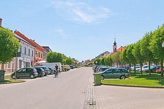
Grybów, is a town in the Nowy Sącz County, in Lesser Poland Voivodeship of Poland, with 12,409 inhabitants (2005). It is located in the heartland of the Doły Jasielsko Sanockie, and its average altitude is 370 metres above sea level, although there are some hills located within the confines of the city, Grybów has the steepest town square in medieval Europe.

Bjni, is a village in the Kotayk Province of Armenia. It is situated in a valley between canyon walls and a small river. The village is one of the prominent centers of education and culture of ancient and medieval Armenia. It is the birthplace of the 11th-century scholar Grigor Magistros.

Meszlen is a village in Vas county, Hungary, located 15 kilometers northeast of Szombathely. Neighboring villages are Acsád, Csepreg, Tömörd, Vasasszonyfa, Salköveskút, Kőszegpaty.

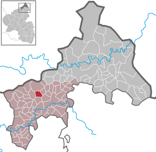
Birnbach is a municipality in the district of Altenkirchen, in Rhineland-Palatinate, Germany.

Gardoš is an urban neighborhood of Belgrade, the capital of Serbia. It is located in Belgrade's municipality of Zemun. Located on the slopes of the hill of the same name, with its tower and preserved old architecture, Gardoš is the major historical landmark of Zemun. Remnants of the Gardoš Fortress, built in the 14th century and the 15th century, are the oldest surviving parts of Zemun.

Karchevan is a village in the Meghri Municipality of the Syunik Province in Armenia.
Bobrowniki is a village in the administrative district of Gmina Ryki, within Ryki County, Lublin Voivodeship, in eastern Poland. It lies in northeastern corner of historic Lesser Poland, approximately 10 kilometres (6 mi) south of Ryki and 56 km (35 mi) north-west of the regional capital Lublin. The village was officially a town from 1485 to 1869.

Türje is a village in Zala County, Hungary. The village is located in the North-Eastern part of Zala County, near the great turn of Zala river, between the Keszthelyi Mountains and Kemeneshát Hills. The village has a railway station on the line of the Boba–Őrihodos railway which is connecting the two local centers of Zalaegerszeg and Celldömölk. It is also connected with Zalaszentgrót by bus.

Hostouň is a municipality and village in Kladno District in the Central Bohemian Region of the Czech Republic. It has about 1,600 inhabitants.

Carme is a municipality in the comarca of the Anoia in Catalonia, Spain. The town is in the middle of a valley, which is surrounded by the Orpinell range and the other by the Collbàs range. The village is at the bottom of the valley and is surrounded by forests. The capital of the region of Anoia, Igualada, is just ten kilometers from the village, while other municipalities like La Pobla de Claramunt or Capellades are about five kilometers from the village. Currently the village has approximately 800 inhabitants, but in holiday seasons this figure may be slightly increased.

Iskra is a village in southern Bulgaria it is the southernmost village in the Parvomay Municipality, Plovdiv Province. It has the largest population outside the town of Parvomay in the municipality. It is 22 km to the south of Parvomay town, 8 km to the north of village Novakovo, 7 km to the east of village Lenovo and 8 km to the south of village Bryagovo.
Agios Stefanos is a village within the Lasithi prefecture in eastern Crete. It belonged to the former province of Siteia until that was abolished in 2006. Between 1997 and 2010, it was part of the former Makry Gialos municipality. Today, it is part of Ierapetra municipality. It is located 30 kilometers north-east of Ierapetra, 40 kilometers southwest of Sitia, and six kilometers east of Stavrohori. It can be approached through the famous forest of Pefkoseli. Its patron is Saint Stephen. Saint Stephen church, at the entrance of the village, is an ecclesiastical and historical monument of Crete. Since the last decade, the majority of the population has been moved to the village's seaside settlement of Makry Gialos, some six kilometers to the south. Makry Gialos is one of Crete's most important tourist resorts.

Saint Christopher Monastery is a restored Armenian church of the 7th century, located in a cemetery 2.2 kilometres (1.4 mi) southeast of the outskirts of Dashtadem village and Dashtadem Fortress in the Aragatsotn Province of Armenia. Adjacent to the church (north) is a 13th-century stone rectangular tower (bell/defensive/funerary) with sloped walls. It has small windows on the upper portion of the wall, but no access to the interior. The surrounding cemetery has been in use from the 6th century to modern times, and contains several interesting khachkars. A low-stone wall surrounds the complex and a section of the old cemetery. Dashtadem Fortress may be seen in the distance from the monastery.

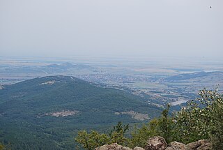
The Christianization of the Olympus region began relatively early. While the episcopal seats from Byzantine times only remaining ruins, inhabited and used monasteries and churches are still present at this time at Olympus. Some of the monasteries are a stauropegion, ie they are directly subordinate to the Patriarch of Constantinople, others belong to a diocese. The number of churches and chapels around Mount Olympus is hard to overlook. That is why only the monasteries and most important churches are mentioned.

The Cheremi historic site is a historic and archaeological site in eastern Georgia, situated in and around the modern village of Cheremi, Gurjaani Municipality, in the region of Kakheti. The site encompasses the ruins of churches, a castle with a circuit wall, and burials. Parts of these ruins correspond to the extinct town of Cheremi known from the early medieval Georgian chronicles and are inscribed on the list of the Immovable Cultural Monuments of National Significance.


