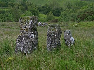
Drumskinny is the site of a stone circle in the townland of Drumskinny, County Fermanagh, Northern Ireland. With the inclusion of an adjacent cairn and alignment, the stone circle is a State Care Historic Monument in Fermanagh and Omagh district, at grid ref: H 2009 7072. The site was excavated in 1962 and is believed to have built around 2000 BC.

Belleek is a village and civil parish in County Fermanagh, Northern Ireland. While the greater part of the village lies within County Fermanagh, part of it crosses the border and the River Erne into County Donegal. It lies in the historic barony of Lurg. It had a population of 904 people in the 2011 Census, and is situated within Fermanagh and Omagh district.

Belmore Mountain is a hill in the townland of Gortgall, western County Fermanagh, Northern Ireland. With a summit roughly 398 metres (1,306 ft) above sea level, it is the second highest point in Fermanagh, the highest being at Cuilcagh on the Northern Ireland–Republic of Ireland border in the south of the county. The historian John O Donovan (1834) states that the indigenous population called the mountain Bel Mor Muintir Pheodachain.
Coney Island is a neighborhood, visitor attraction, and former island in Brooklyn, New York.

Laragh is a townland of 132 acres in County Fermanagh, Northern Ireland. It is situated in the civil parish of Trory and the historic barony of Tirkennedy. It is near Enniskillen Airport.
Trory is a townland, small village and civil parish in County Fermanagh, Northern Ireland, 3 miles (5 km) north of Enniskillen. The townland is situated in the historic barony of Tirkennedy, but the civil parish covers areas of the barony of Tirkennedy, as well as the barony of Lurg. In the 2001 Census it had a population of 315 people. It lies within the Fermanagh and Omagh District Council area.

Lack is a small village and townland in County Fermanagh, Northern Ireland, 5.5 km east-north-east of Ederny. It is situated in the civil parish of Magheraculmoney and the historic barony of Lurg. It had a population of 111 people in the 2011 Census..

Lusty Beg Island is an island located in Lower Lough Erne, in County Fermanagh, Northern Ireland. In the early 20th century, Lady Hunt from Alberta in Canada owned Lustymore Island and Lusty Beg Island. When her residence, Glenvar House, on Lustymore was accidentally burned down, Lady Hunt moved to Germany.
Eagle Island may refer to:
Horse Island is the name of several places, including:
Aghalurcher is a civil parish located mainly in the barony of Magherastephana in County Fermanagh and partly in the barony of Clogher in County Tyrone, Northern Ireland.
Levally Lower is a townland approximately 4.5 miles (7.2 km) from Enniskillen, County Fermanagh, along the main Enniskillen to Belleek road. It is primarily located between the Levally Road and the Drumcose Road.

Kilnamadoo is a townland in County Fermanagh, Northern Ireland. It is situated within the civil parish of the area of Boho, as well as Fermanagh and Omagh district.
Moylehid is a townland in County Fermanagh, Northern Ireland. It is in the civil parish of Boho. This townland has also been variously known as Moylehide (1609), Moolet (1659), Moylehit, Mullyleet, Mul Leathaid and Mul-leithid (1834).

Tomregan is a civil parish in the ancient barony of Tullyhaw. The parish straddles the international border between the Republic of Ireland and Northern Ireland. The largest population centre in the parish is Ballyconnell, County Cavan. The total area of the civil parish is 10,600 statute acres. Most of Tomregan's constituent townlands are situated in County Cavan while the remainder lie in County Fermanagh. In the Catholic Church, the ecclesiastical parish of Tomregan was split in the early 18th century, with the County Fermanagh townlands being assigned to the parish of Knockninny while the County Cavan townlands were united with the parish of Kildallan.

Magheracross is a townland and civil parish in County Fermanagh, Northern Ireland. It extends in area from just north of Enniskillen to the Border with County Tyrone. There is also a small enclave in County Tyrone.
Knocks is a townland to the east of Lisnaskea in County Fermanagh, Northern Ireland. It is situated in the historic barony of Magherastephana and the civil parish of Aghalurcher and covers an area of 193 acres.
Derryvullan is a civil parish and townland in County Fermanagh, Northern Ireland. The civil parish is situated in the historic baronies of Tirkennedy and Lurg. Derryvullan townland is in the portion of the parish of the same name in Tirkennedy.