
The Red Rock Canyon National Conservation Area in Clark County, Nevada, United States, is an area managed by the Bureau of Land Management as part of its National Landscape Conservation System, and protected as a National Conservation Area. It is about 15 miles (24 km) west of Las Vegas. More than three million people visit the area each year.

The Santa Monica Mountains are a coastal mountain range in Southern California, next to the Pacific Ocean. It is part of the Transverse Ranges. The Santa Monica Mountains National Recreation Area encompasses this mountain range. Because of its proximity to densely populated regions, it is one of the most visited natural areas in California.

Pacific Palisades is a neighborhood in the Westside region of Los Angeles, California, situated about 20 miles (32 km) west of Downtown Los Angeles.

Red Rocks Park is a mountain park in Jefferson County, Colorado, owned and maintained by the city of Denver as part of the Denver Mountain Parks system. The park is known for its very large red sandstone outcrops. Many of these rock formations within the park have names, from the mushroom-shaped Seat of Pluto to the inclined Cave of the Seven Ladders. The most visited rocks, around Red Rocks Amphitheatre, are Creation Rock to the north, Ship Rock to the south, and Stage Rock to the east.

Colorado National Monument is a National Park Service unit near the city of Grand Junction, Colorado. Sheer-walled canyons cut deep into sandstone and granite–gneiss–schist rock formations. This is an area of desert land high on the Colorado Plateau, with pinyon and juniper forests on the plateau. The park hosts a wide range of wildlife, including red-tailed hawks, golden eagles, ravens, jays, desert bighorn sheep, and coyotes. Activities include hiking, horseback riding, road bicycling, and scenic drives; a visitor center on the west side contains a natural history museum and gift shop. There are scenic views from trails, Rim Rock Drive, which winds along the plateau, and the campground. Nearby are the Book Cliffs and the largest flat-topped mountain in the world, the Grand Mesa.

Topanga State Park is a California state park located in the Santa Monica Mountains, within Los Angeles County, California. It is part of the Santa Monica Mountains National Recreation Area.

Smith Rock State Park is a state park located in central Oregon's High Desert near the communities of Redmond and Terrebonne. The day-use area of the park is open daily from dawn to dusk. The park also has a camping area as well that accommodates tent camping only. Its sheer cliffs of tuff and basalt are ideal for rock climbing of all difficulty levels. Smith Rock is generally considered the birthplace of modern American sport climbing, and is host to cutting-edge climbing routes. It is popular for sport climbing, traditional climbing, multi-pitch climbing, and bouldering.

The Santa Monica Mountains National Recreation Area is a United States national recreation area containing many individual parks and open space preserves, located primarily in the Santa Monica Mountains of Southern California. The SMMNRA is in the greater Los Angeles region, with two thirds of the parklands in northwest Los Angeles County, and the remaining third, including a Simi Hills extension, in southeastern Ventura County.

Bow Valley Provincial Park is a provincial park in Alberta, Canada. Established in 1959 in the arch of the Bow River at its confluence with the Kananaskis River, the park is one park of many within the Kananaskis Country park system.

Blue Knob State Park is a 6,128-acre (2,480 ha) Pennsylvania state park in Kimmel, Lincoln, and Pavia townships in Bedford County, Pennsylvania, in the United States. The average annual snowfall at the park is about 12 feet (370 cm). The park is named for Blue Knob, the second highest mountain in Pennsylvania at 3,146 feet (959 m). It is the location of Blue Knob All Seasons Resort, the ski slope in Pennsylvania with the highest elevation. Blue Knob State Park is just off Interstate 99 on Pennsylvania Route 869 west of Pavia.
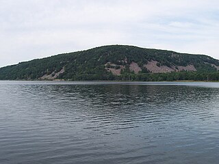
Devil's Lake is a lake in the South Range of the Baraboo Range, about two miles south of Baraboo, Wisconsin, in Sauk County, Wisconsin, United States. It has no surface outlets, so by some definitions, it is endorheic; however, it possibly drains by underground channels into the Baraboo River, which would make the lake cryptorheic. The lake is one of the primary attractions of Devil's Lake State Park. It is also a popular recreation destination for watercraft, fishing, hiking, and climbing.

Snow Canyon State Park is a state park in Utah, located in the Red Cliffs Desert Reserve. The park features a canyon carved from the red and white Navajo sandstone of the Red Mountains, as well as the extinct Santa Clara Volcano, lava tubes, lava flows, and sand dunes. Snow Canyon is located near the cities of Ivins and St. George in Washington County.

Ravensburg State Park is a Pennsylvania state park in Crawford Township in Clinton County, Pennsylvania in the United States. It is in a gorge carved by Rauchtown Run through the side of Nippenose Mountain. Ravensburg State Park is 78 acres (32 ha) of wooded land that is almost entirely surrounded by Tiadaghton State Forest. This state park is on Pennsylvania Route 880, 8 miles (13 km) north of Carroll and 8 miles (13 km) south-east of Jersey Shore. The nearest city is Williamsport.

Bald Eagle Valley is a low-lying area in Pennsylvania that drains into Bald Eagle Creek between the Allegheny Front and Bald Eagle Mountain, south of the West Branch Susquehanna River, in the Ridge-and-valley Appalachians. The valley is located southwest of West Branch Susquehanna Valley and includes Williamsport, Nittany Valley, and State College in the central portion of Centre County and southern portion of Clinton County.

Bald Eagle Mountain – once known locally as Muncy Mountain – is a stratigraphic ridge in the Ridge-and-Valley Appalachians of central Pennsylvania, United States, running east of the Allegheny Front and northwest of Mount Nittany. It lies along the southeast side of Bald Eagle Creek and south of the West Branch Susquehanna River, and is the westernmost ridge in its section of the Ridge-and-Valley Appalachians. The ridge line separates the West Branch Susquehanna Valley from the Nippenose and White Deer Hole valleys, and Bald Eagle Valley from Nittany Valley.

The Backbone Trail is a long-distance trail extending 67.79 miles (109.10 km) across the Santa Monica Mountains in the U.S. state of California. Its western terminus is Point Mugu State Park, and its eastern terminus is Will Rogers State Historic Park in Pacific Palisades. The trail is open to hikers throughout its length. Dogs, mountain bicyclists and horseback riders are only allowed on portions of the trail as posted.

Sage Ranch Park is a 625-acre park (253 ha) and wildlife corridor located at a 2,000 feet (610 m) height in the northwestern Simi Hills on the northwestern plateau of the Simi Valley, bordering Los Angeles County and its San Fernando Valley. The campground area used to be a cattle ranch and later a filmset for Western movies. Sage Ranch Park is today an intermountain wildlife corridor, which links the Simi Hills with the Santa Susana- and Santa Monica Mountains. The mountainous park is mostly known for its unique sandstone rock formations, maybe particularly on its western side where the Sandstone Ridge and Turtle Rock are situated. On its northern side, there are great panoramic rural and metropolitan views of the Simi Valley, as well as surrounding Simi Hills, Santa Susana Mountains and beyond. It is home to numerous sandstone formations, caves, outcroppings, tilted rock formations, several hiking trails, a camping ground, as well as native flora and wildlife. The area is lined with coastal sage scrub and other flora includes chaparral, bush lupine, California poppy, sunflowers, Cream Cups, bracken, sword fern, prickly pear cactus, eucalyptus trees, oak woodland of ceanothus, coffee berry, California buckwheat, sycamore, Walnut Tree, ferns, orange- and avocado trees. It is a critical cross-mountain wildlife corridor and is home to fauna such as mountain lions, bobcats, eagles, vultures, owls, rattle snakes, coyotes, hawks, grey fox, king snakes, and more. Bordering Sage Ranch to the south is the Rocketdyne Santa Susana Field Laboratory, in which the nearby Burro Flats Painted Cave is located.
Klondike Park is a county park in St. Charles County, Missouri. The park offers access to hiking and cycling trails including the Katy Trail. Camping and fishing facilities are also available. Klondike park also has a very diverse set of wildlife and habitats.

Eagle Crags is a 6,380-foot (1,940 m) elevation summit located in the Canaan Mountain Wilderness of Washington County in southwest Utah, United States.
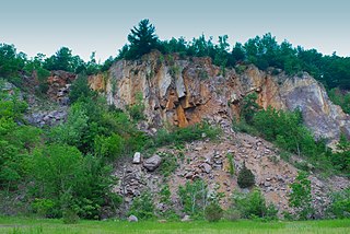
Ableman's Gorge is a 127 acres (51 ha) Wisconsin State Natural Area located near Rock Springs, Wisconsin. This 200 to 400-foot wide and 200-foot high gorge is cut by about 1 mile (1.6 km) of the Baraboo River in an "L" shape. The Natural Area is named after Stephen Van Rensselaer Ableman, who settled Rock Springs in 1851 and named the community after the gorge area.

