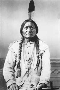
Early Indian treaty territories in North Dakota

Last updated
Early Indian treaty territories, North Dakota - an overview map Early Indian treaty territories, North Dakota - an overview map.png
Early Indian treaty territories, North Dakota - an overview map

Native Americans from various tribes lived in North Dakota before the arrival of settlers. With time, a number of treaties and agreements were signed between the Indians and the newcomers. Many of the treaties defined the domain of a specific group of Indians. The three maps below show the treaty territories of different Indians living in North Dakota and how the territories changed and diminished over time in the 19th century.

North Dakota State of the United States of America

North Dakota is a U.S. state in the midwestern and northern regions of the United States. It is the nineteenth largest in area, the fourth smallest by population, and the fourth most sparsely populated of the 51 states. North Dakota was admitted to the Union on November 2, 1889, along with its neighboring state, South Dakota. Its capital is Bismarck, and its largest city is Fargo.

Contents

(The Dakota Territory became a reality on March 2, 1861. Most treaties and agreements antedate the final division of the territory into the Dakotas. For sake of convenience, "North Dakota" is used in the text instead of "present-day North Dakota". The narrow tracks of Indian territories in the southernmost part of North Dakota is not discussed here, since they were segments of considerable areas in South Dakota.)

Dakota Territory territory of the USA between 1861-1889

The Territory of Dakota was an organized incorporated territory of the United States that existed from March 2, 1861, until November 2, 1889, when the final extent of the reduced territory was split and admitted to the Union as the states of North and South Dakota.

South Dakota State of the United States of America

South Dakota is a U.S. state in the Midwestern region of the United States. It is named after the Lakota and Dakota Sioux Native American tribes, who compose a large portion of the population and historically dominated the territory. South Dakota is the seventeenth largest by area, but the fifth smallest by population and the 5th least densely populated of the 50 United States. As the southern part of the former Dakota Territory, South Dakota became a state on November 2, 1889, simultaneously with North Dakota. Pierre is the state capital and Sioux Falls, with a population of about 187,200, is South Dakota's largest city.

Map 1

Early Indian treaty territories, North Dakota. Map 1 (1851-1891) Early Indian treaty territories, North Dakota. Map 1 (1851-1891).png
Early Indian treaty territories, North Dakota. Map 1 (1851-1891)

Area 445 (map 1)

Area 445 was the land of the Red Lake and Pembina bands of the Chippewa. It extended eastward into Minnesota. The Indians ceded the entire area in North Dakota on October 2, 1863 [1] :828-829 and gathered in unceded land in Minnesota.

Pembina Band of Chippewa Indians are a historical band of Chippewa (Ojibwe), originally living along the Red River of the North and its tributaries. Through the treaty process with the United States, the Pembina Band were settled on reservations in Minnesota and North Dakota. Some tribal members refusing settlement in North Dakota relocated northward and westward, some eventually settling in Montana.

Minnesota State of the United States of America

Minnesota is a state in the Upper Midwest, Great Lakes, and northern regions of the United States. Minnesota was admitted as the 32nd U.S. state on May 11, 1858, created from the eastern half of the Minnesota Territory. The state has a large number of lakes, and is known by the slogan the "Land of 10,000 Lakes". Its official motto is L'Étoile du Nord.

Red Lake Indian Reservation

The Red Lake Indian Reservation (Miskwaagamiiwi-zaaga'igan) covers 1,259 sq mi in parts of nine counties in northwestern Minnesota, United States. It is made up of numerous holdings but the largest section is an area about Red Lake, in north-central Minnesota, the largest lake entirely within that state. This section lies primarily in the counties of Beltrami and Clearwater. Land in seven other counties is also part of the reservation.

Areas 496, 497 and 538 (map 1)

The Sisseton and Wahpeton bands of the Santee Sioux claimed these areas, with area 538 extending around 75 miles into South Dakota. On February 19, 1867, they allowed the construction of roads and railroads through it. The Indians ceded no land with the signing of this treaty. [2] :956-959 [1] :842-843 Two reservations were established. Area 496 indicates the Sisseton reservation at Lake Traverse in the South. A northern reservation adjoined Devil's Lake (area 497). On September 20, 1872, the Indians ceded the yellow area 538. [1] :858-859 The agreement (modified by amendments) was ratified on June 22, 1874. [1] :874-875 By "agreement" and "Act of Congress", all unallotted land in Lake Traverse Indian Reservation (area 496) was ceded to the United States on March 3, 1891. [1] :942-943

Dakota people native American people in the mid northern U.S. and mid southern Canada

The Dakota are a Native American tribe and First Nations band government in North America. They compose two of the three main subcultures of the Sioux people, and are typically divided into the Eastern Dakota and the Western Dakota.

Sisseton Wahpeton Oyate Native American tribal organization in South Dakota and North Dakota

The Sisseton Wahpeton Oyate of the Lake Traverse Reservation, formerly Sisseton-Wahpeton Sioux Tribe/Dakota Nation, is a federally recognized tribe comprising two bands and two sub-divisions of the Isanti or Santee Dakota people. They are located on the Lake Traverse Reservation in northeast South Dakota.

Spirit Lake Tribe Native American tribal organization in North Dakota

The Spirit Lake Tribe is a federally recognized tribe based on the Spirit Lake Dakota Reservation located in east-central North Dakota on the southern shores of Devils Lake. It is made up of people of the Pabaksa (Iháŋkthuŋwaŋna), Sisseton (Sisíthuŋwaŋ) and Wahpeton (Waȟpéthuŋwaŋ) bands of the Dakota tribe. Established in 1867 in a treaty between Sisseton-Wahpeton Bands and the United States government, the reservation, at 47°54′38″N98°53′01″W, consists of 1,283.777 square kilometres (495.669 sq mi) of land area, primarily in Benson and Eddy counties. Smaller areas extend into Ramsey, Wells and Nelson counties.

Area 516 (map 1)

This area west of Missouri River and south of Heart River was recognized as a part of a larger Lakota territory in the Treaty of Fort Laramie (1851). [2] :594-596 To end Red Cloud's War, a new Fort Laramie treaty was negotiated, accepted and dated April 29, 1868. The Lakotas ceded area 516 in North Dakota to the United States. [2] :998-1007 At the same time, they agreed to live in The Great Sioux Reservation mainly located west of the Missouri in South Dakota.

Missouri River major river in the central United States, tributary of the Mississippi

The Missouri River is the longest river in North America. Rising in the Rocky Mountains of western Montana, the Missouri flows east and south for 2,341 miles (3,767 km) before entering the Mississippi River north of St. Louis, Missouri. The river drains a sparsely populated, semi-arid watershed of more than 500,000 square miles (1,300,000 km2), which includes parts of ten U.S. states and two Canadian provinces. Although nominally considered a tributary of the Mississippi, the Missouri River above the confluence is much longer and carries a comparable volume of water. When combined with the lower Mississippi River, it forms the world's fourth longest river system.

Heart River (Alberta) river in Canada

The Heart River is a river in northern Alberta, Canada. It is a major tributary of the Peace River.

Lakota people Indigenous people of the Great Plains

The Lakota are a Native American tribe. Also known as the Teton Sioux, they are one of the three Sioux tribes of Plains. Their current lands are in North and South Dakota. They speak Lakȟótiyapi—the Lakota language, the westernmost of three closely related languages that belong to the Siouan language family.

Indian territories, North Dakota. Map 2 (1875-1889) Indian territories, North Dakota. Map 2 (1875-1889).png
Indian territories, North Dakota. Map 2 (1875-1889)

Areas 581, 599 and 653 (map 2)

By executive order of March 16, 1875, some of the land ceded in 1868 turned back into the holdings of the Sioux tribe (green area 581) and also extra land east of the Missouri (the area framed with a green line). [1] :880-881 The small area east of the river adjoined an existing Yankton Sioux Reservation chiefly in South Dakota (the yellow area). Later, on August 9, 1879, some of this new, eastern land was relinquished by executive order (the yellow area framed with green). [1] :880-881

Yankton Indian Reservation Sioux Indian Reservation in the South Dakota

The Yankton Indian Reservation is the homeland of the Yankton subgroup of the Dakota tribe of Native Americans.

Nearly three months after the Battle of the Little Bighorn, the Sioux "ceded all claim" to about one-quarter of the Great Sioux Reservation in South Dakota in a controversial agreement. This agreement of September 9, 1876, added an extra tract to the Sioux land in North Dakota (blue area 599). It was end-to-end with a part of the northern border of what was left of the Great Sioux Reservation as well as area 581 added the year before. [1] :888-889 On November 28, still 1876, the "President makes another addition" to the Sioux land east of the Missouri by executive order. [1] :888-889 This section is only indicated by the pointed area delimited by dark blue lines. By another executive order of August 9, 1879, the very same area was restored to "public domain". [1] :888-889 A small tract of land bordering the Missouri returned into the holding of the United States by executive order of March 20, 1884 (light scarlet area 653). [1] :914-915 Area 599, added in 1876, was subtracted again on March 2, 1889, by act of Congress. [1] :930-931 (An earlier act to the same effect came not into force, "because of failure to obtain the consent of the Sioux". [1] :930-931 The new act was passed "with the understanding that it would be accepted. The agreement thereto was proclaimed by the President Feb. 10, 1890.") [1] :930-931

Areas 529, 620 and the part of 621 south of the Missouri (map 1)

These three ranges together show the mutual Indian territory of the Arikara, Hidatsa and Mandan as defined in the Treaty of Fort Laramie (1851). [2] :594-596 It extended into Montana and Wyoming. Area 529 turned into U.S. territory on April 12, 1870, by executive order. The Fort Berthold Reservation was established at the same occasion. Further, the United States recognized a narrow tract north of the Missouri as Arikara, Hidatsa and Mandan territory (indicated by the yellow, dotted line). [3] :map facing p. 112 This was crucial to the Indians, since they had their only permanent settlement - Like-a-Fishhook Village - located here. Another executive order of July 13, 1880, subtracted area 620 from the tribes' holdings. [3] :map facing p. 112

Areas 712, 713 and 716 (map 3 -below)

However, extra land straight north of the Missouri made up for some of the loss. Combined area 712 and 713 show the total expense of the Fort Berthold Reservation in 1880. [3] :map facing p. 112 Area 712 was ceded to the United States on December 14, 1886, by agreement (ratified on March 3, 1891). [3] :map facing p. 112 [1] :942-943 Area 713 shows the reduced holdings of the Arikara, Hidatsa and Mandan. The acreage of the reservation increased slightly with the addition of a small tract on the east side of it on June 17, 1892, by executive order (area 716). [1] :944-945

Map 3

Indian territories, North Dakota. Map 3 (1880-1892) Indian territories, North Dakota. Map 3 (1880-1892).png
Indian territories, North Dakota. Map 3 (1880-1892)

Areas 654 and 656 (map 2 and also section of map 2)

Turtle Mountain Chippewa reserve, 1882 and 1884. Section of map 2 Turtle Mountain Chippewa reserve, 1882 and 1884.png
Turtle Mountain Chippewa reserve, 1882 and 1884. Section of map 2

The areas combined indicates a reserve for the Chippewa (Turtle Mountain band) established on December 21, 1882 by executive order. [1] :908-909 Two years later the major part of it was relinquished by executive order of March 29, 1884. [1] :916-917 The diminished reserve for the Turtle Mountain Chippewa is shown as two yellow survey townships. Within three months, the "President amends Executive order of Mar. 29, 1884" with its far from practical division of the reserve. The executive order of June 3, 1884, made the reserve a whole (the southern half of the reserve was moved one survey township westward – not shown on the map). [1] :916-917


Related Research Articles

The Mandan, Hidatsa, and Arikara Nation, also known as the Three Affiliated Tribes, is a Native American Nation resulting from the alliance of the Mandan, Hidatsa, and Arikara peoples, whose native lands ranged across the Missouri River basin extending from present day North Dakota Through western Montana and Wyoming.

Arikara War

The Arikara War was an armed conflict between the United States, their allies from the Sioux tribe and Arikara Native Americans that took place in the summer of 1823, along the Missouri River in present-day South Dakota. It was the first Indian war west of the Missouri fought by the U.S. Army and its only conflict ever with the Arikara. The war came as a response to an Arikara attack on trappers, called "the worst disaster in the history of the Western fur trade".

Treaty of Fort Laramie (1868) 1868 treaty between the government and Native Americans which ended Red Clouds War

The Treaty of Fort Laramie was an agreement between the United States and the Oglala, Miniconjou, and Brulé bands of Lakota people, Yanktonai Dakota and Arapaho Nation, following the failure of the first Fort Laramie treaty, signed in 1851.

Hidatsa ethnic group

The Hidatsa are a Siouan people.

Arikara ethnic group

Arikara, also known as Sahnish, Arikaree or Hundi, are a tribe of Native Americans in North Dakota. Today, they are enrolled with the Mandan and the Hidatsa as the federally recognized tribe known as the Mandan, Hidatsa, and Arikara Nation.

Mandan ethnic group

The Mandan are a Native American tribe of the Great Plains who have lived for centuries primarily in what is now North Dakota. They are enrolled in the Three Affiliated Tribes of the Fort Berthold Reservation. About half of the Mandan still reside in the area of the reservation; the rest reside around the United States and in Canada.

Treaty of Fort Laramie (1851) treaty on territorial claims of Native Americans

The Fort Laramie Treaty of 1851 was signed on September 17, 1851, between United States treaty commissioners and representatives of the Cheyenne, Sioux, Arapaho, Crow, Assiniboine, Mandan, Hidatsa, and Arikara Nations. The treaty was an agreement between nine more or less independent parties. The treaty set forth traditional territorial claims of the tribes as among themselves. The United States acknowledged that all the land covered by the treaty was Indian territory and did not claim any part of it. The boundaries agreed to in the Fort Laramie treaty of 1851 would be used to settle a number of claims cases in the 20th century. The Native Americans guaranteed safe passage for settlers on the Oregon Trail and allowed roads and forts to be built in their territories in return for promises of an annuity in the amount of fifty thousand dollars for fifty years. The treaty should also "make an effective and lasting peace" among the eight tribes, each of them often at odds with a number of the others.

Hunkpapa traditional tribal grouping within the Lakota people

The Hunkpapa are a Native American group, one of the seven council fires of the Lakota tribe. The name Húŋkpapȟa is a Lakota word meaning "Head of the Circle". By tradition, the Húŋkpapȟa set up their lodges at the entryway to the circle of the Great Council when the Sioux met in convocation. They speak Lakȟóta, one of the three dialects of the Sioux language.

Fort Berthold Indian Reservation

The Fort Berthold Indian Reservation is a U.S. Indian reservation in western North Dakota that is home for the federally recognized Mandan, Hidatsa, and Arikara Nation, also known as the Three Affiliated Tribes. The reservation includes lands on both sides of the Missouri River.

Like-a-Fishhook Village

Like-a-Fishhook Village was a Native American settlement next to Fort Berthold in North Dakota, established by dissident bands of the Three Affiliated Tribes, the Mandan, Arikara and Hidatsa. Formed in 1845, it was also eventually inhabited by non-Indian traders, and became important in the trade between Natives and non-Natives in the region.

The Intertribal Council On Utility Policy, or Intertribal COUP, is a Native American nonprofit organization founded in 1994 that addresses energy, telecommunications, and environmental issues affecting member tribes in North Dakota, South Dakota, Nebraska and Wyoming.

Fort Belknap Indian Reservation Reservation/Nation

The Fort Belknap Indian Reservation is shared by two Native American tribes, the A'aninin and the Nakoda (Assiniboine). The reservation covers 1,014.064 square miles (2,626.41 km2), and is located in north central Montana. The total area includes the main portion of their homeland, as well as off-reservation trust land. The tribes reported a total of 2,851 enrolled members in 2010. The capital and largest city is Fort Belknap Agency, at the reservation's north end. This is just south of the city of Harlem across the Milk River.

Treaty of Traverse des Sioux

The Treaty of Traverse des Sioux was a treaty signed on July 23, 1851, at Traverse des Sioux in Minnesota Territory between the United States government and Sioux Indian bands in Minnesota Territory. By this treaty, the Sioux ceded large tracts of territory and agreed to move on to reservations along the Minnesota River in exchange for annuities of cash and goods.

The history of South Dakota describes the history of the U.S. state of South Dakota over the course of several millennia, from its first inhabitants to the recent issues facing the state.

Thomas Little Shell Ojibwe leader

Thomas Little Shell (c.1830-1901), was a chief of a band of the Ojibwa (Chippewa) tribe in the second half of the nineteenth century, when the Anishinaabeg had a vast territory ranging from southwestern Canada into the northern tier of the United States, from the Dakotas and into Montana.

Fort Berthold was two sequential forts on the Missouri River in North Dakota, both of which began as fur trading posts. The second became a post for the U.S. Army and later became the Indian Agency for the Arikara, Hidatsa, and Mandan tribes. The sites are both now under Lake Sakakawea.

This timeline of South Dakota is a list of events in the history of South Dakota by year.

Early Indian treaty territories in Montana

A number of different Native Americans living in present-day Montana entered into treaties with the United States during the 19th Century. Most of the treaties included an article that established the territory of the tribe entering into it. More and more of this Indian land turned into public or U.S. territory with the signing of new treaties..

Crow Flies High Hidatsa chief

Crow Flies High was the chief of a band of dissident Hidatsa people from 1870 until their band joined the reservation system in 1894. This band was one of the last to settle on an Indian reservation. A North Dakota State Park is named after him.
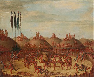
References

  1. 1 2 3 4 5 6 7 8 9 10 11 12 13 14 15 16 17 18 19 U.S. Serial Set, No. 4015, 56th Congress, 1st Session
  2. 1 2 3 4 Kappler, Charles J. (1904): Indian Affairs. Laws and Treaties. Vol. 2. Washington.
  3. 1 2 3 4 Meyer, Roy W, (1977): The Village Indians of the Upper Missouri. The Mandans, Hidatsas, and Arikaras. Lincoln and London.