
A communications satellite is an artificial satellite that relays and amplifies radio telecommunication signals via a transponder; it creates a communication channel between a source transmitter and a receiver at different locations on Earth. Communications satellites are used for television, telephone, radio, internet, and military applications. Many communications satellites are in geostationary orbit 22,300 miles (35,900 km) above the equator, so that the satellite appears stationary at the same point in the sky; therefore the satellite dish antennas of ground stations can be aimed permanently at that spot and do not have to move to track the satellite. Others form satellite constellations in low Earth orbit, where antennas on the ground have to follow the position of the satellites and switch between satellites frequently.

An Earth observation satellite or Earth remote sensing satellite is a satellite used or designed for Earth observation (EO) from orbit, including spy satellites and similar ones intended for non-military uses such as environmental monitoring, meteorology, cartography and others. The most common type are Earth imaging satellites, that take satellite images, analogous to aerial photographs; some EO satellites may perform remote sensing without forming pictures, such as in GNSS radio occultation.
The Ku band is the portion of the electromagnetic spectrum in the microwave range of frequencies from 12 to 18 gigahertz (GHz). The symbol is short for "K-under", because it is the lower part of the original NATO K band, which was split into three bands because of the presence of the atmospheric water vapor resonance peak at 22.24 GHz, (1.35 cm) which made the center unusable for long range transmission. In radar applications, it ranges from 12 to 18 GHz according to the formal definition of radar frequency band nomenclature in IEEE Standard 521–2002.

High frequency (HF) is the ITU designation for the range of radio frequency electromagnetic waves between 3 and 30 megahertz (MHz). It is also known as the decameter band or decameter wave as its wavelengths range from one to ten decameters. Frequencies immediately below HF are denoted medium frequency (MF), while the next band of higher frequencies is known as the very high frequency (VHF) band. The HF band is a major part of the shortwave band of frequencies, so communication at these frequencies is often called shortwave radio. Because radio waves in this band can be reflected back to Earth by the ionosphere layer in the atmosphere – a method known as "skip" or "skywave" propagation – these frequencies are suitable for long-distance communication across intercontinental distances and for mountainous terrains which prevent line-of-sight communications. The band is used by international shortwave broadcasting stations (3.95–25.82 MHz), aviation communication, government time stations, weather stations, amateur radio and citizens band services, among other uses.

A weather satellite or meteorological satellite is a type of Earth observation satellite that is primarily used to monitor the weather and climate of the Earth. Satellites can be polar orbiting, or geostationary.
The X band is the designation for a band of frequencies in the microwave radio region of the electromagnetic spectrum. In some cases, such as in communication engineering, the frequency range of the X band is rather indefinitely set at approximately 7.0–11.2 GHz. In radar engineering, the frequency range is specified by the Institute of Electrical and Electronics Engineers (IEEE) as 8.0–12.0 GHz. The X band is used for radar, satellite communication, and wireless computer networks.
The radio spectrum is the part of the electromagnetic spectrum with frequencies from 1 Hz to 3,000 GHz (3 THz). Electromagnetic waves in this frequency range, called radio waves, are widely used in modern technology, particularly in telecommunication. To prevent interference between different users, the generation and transmission of radio waves is strictly regulated by national laws, coordinated by an international body, the International Telecommunication Union (ITU).

A ground station, Earth station, or Earth terminal is a terrestrial radio station designed for extraplanetary telecommunication with spacecraft, or reception of radio waves from astronomical radio sources. Ground stations may be located either on the surface of the Earth, or in its atmosphere. Earth stations communicate with spacecraft by transmitting and receiving radio waves in the super high frequency (SHF) or extremely high frequency (EHF) bands. When a ground station successfully transmits radio waves to a spacecraft, it establishes a telecommunications link. A principal telecommunications device of the ground station is the parabolic antenna.

A satellite navigation or satnav system is a system that uses satellites to provide autonomous geo-spatial positioning. It allows satellite navigation devices to determine their location to high precision using time signals transmitted along a line of sight by radio from satellites. The system can be used for providing position, navigation or for tracking the position of something fitted with a receiver. The signals also allow the electronic receiver to calculate the current local time to a high precision, which allows time synchronisation. These uses are collectively known as Positioning, Navigation and Timing (PNT). Satnav systems operate independently of any telephonic or internet reception, though these technologies can enhance the usefulness of the positioning information generated.
Radiolocation, also known as radiolocating or radiopositioning, is the process of finding the location of something through the use of radio waves. It generally refers to passive uses, particularly radar—as well as detecting buried cables, water mains, and other public utilities. It is similar to radionavigation, but radiolocation usually refers to passively finding a distant object rather than actively one's own position. Both are types of radiodetermination. Radiolocation is also used in real-time locating systems (RTLS) for tracking valuable assets.

Fixed-satellite service is – according to article 1.21 of the International Telecommunication Union's (ITU) Radio Regulations (RR) – defined as A radiocommunication service between earth stations at given positions, when one or more satellites are used; the given position may be a specified fixed point or any fixed point within specified areas; in some cases this service includes satellite-to-satellite links, which may also be operated in the inter-satellite service; the fixed-satellite service may also include feeder links for other space radiocommunication services.
Amateur radio frequency allocation is done by national telecommunication authorities. Globally, the International Telecommunication Union (ITU) oversees how much radio spectrum is set aside for amateur radio transmissions. Individual amateur stations are free to use any frequency within authorized frequency ranges; authorized bands may vary by the class of the station license.
Frequency assignment is the authorization of use of a particular radio frequency.

Radio is the technology of signaling and communicating using radio waves. Radio waves are electromagnetic waves of frequency between 30 hertz (Hz) and 300 gigahertz (GHz). They are generated by an electronic device called a transmitter connected to an antenna which radiates the waves, and received by another antenna connected to a radio receiver. Radio is widely used in modern technology, in radio communication, radar, radio navigation, remote control, remote sensing, and other applications.
An amateur radio satellite is an artificial satellite built and used by amateur radio operators. It forms part of the Amateur-satellite service. These satellites use amateur radio frequency allocations to facilitate communication between amateur radio stations.
One way of outlining the subject of radio science is listing the topics associated with it by authoritative bodies.

A ground segment consists of all the ground-based elements of a space system used by operators and support personnel, as opposed to the space segment and user segment. The ground segment enables management of a spacecraft, and distribution of payload data and telemetry among interested parties on the ground. The primary elements of a ground segment are:
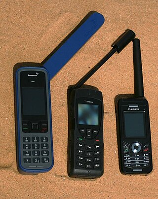
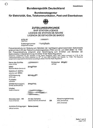
Mobile-satellite service is – according to Article 1.25 of the International Telecommunication Union's Radio Regulations – "A radiocommunication service

Standard frequency and time signal-satellite service is, according to Article 1.54 of the International Telecommunication Union's (ITU) Radio Regulations (RR), defined as A radiocommunication service using space stations on earth satellites for the same purposes as those of the standard frequency and time signal service.

Broadcasting-satellite service is – according to Article 1.39 of the International Telecommunication Union's (ITU) Radio Regulations (RR) – defined as «A radiocommunication service in which signals transmitted or retransmitted by space stations are intended for direct reception by the general public. In the broadcasting-satellite service, the term “direct reception” shall encompass both individual reception and community reception.»