European Remote-Sensing Satellite

Last updated

A full-size model of ERS-2. ERS 2.jpg
A full-size model of ERS-2.

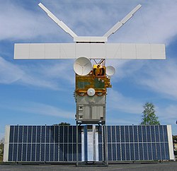
European Remote Sensing satellite (ERS) was the European Space Agency's first Earth-observing satellite programme using a polar orbit. It consisted of two satellites, ERS-1 and ERS-2, with ERS-1 being launched in 1991.

Contents

ERS-1

ERS-1
Mission typeEarth observatrion
COSPAR ID 1991-050A
End of mission
Declared10 March 2000
 

ERS-1 launched 17 July 1991 from Guiana Space Centre aboard an Ariane 4 rocket. [1] The satellite was put into a Sun-synchronous polar orbit at an altitude of 782785 km. ERS-1 failed on 10 March 2000 after nine years in orbit. [2]

Instruments

ERS-1 carried an array of Earth-observation instruments that gathered information about the Earth (land, water, ice, and atmosphere) using a variety of measurement principles. These included:

To accurately determine its orbit, the satellite included the PRARE (Precision Range and Range-Rate Equipment) and a laser retroreflector. The PRARE became non-operational shortly after launch; later analysis concluded that the failure was due to a memory latchup caused by radiation. [3] The retroreflector was used for calibrating the radar altimeter to within 10 cm.

Mission

ERS-1 had various mission phases using 3-day and 35-day repeat cycles. During the geodetic mission, ERS-1 was put in two long repeat cycles of 168 days, which is equivalent to a single 336-day cycle. The geodetic mission allowed for accurate mapping of the Earth's bathymetry and geoid over the seas using the Radar Altimeter.

On 10 March 2000, ERS-1's attitude control system failed due to a gyroscope malfunction and its mission was officially declared finished. [3]

ERS-2

ERS-2
Mission typeEarth observatrion
COSPAR ID 1995-021A
End of mission
Deactivated5 September 2011
Decay date21 February 2024
Orbital parameters
Altitude780 km (480 mi) [4]
Inclination 98.5° [4]
 

Its successor, ERS-2, was launched on 21 April 1995, on an Ariane 4, from ESA's Guiana Space Centre near Kourou, French Guiana. [5] Largely identical to ERS-1, it added additional instruments and improved existing instruments including:

When ERS-2 was launched, ERS-1 shared the same orbital plane. This allowed a tandem mission, with ERS-2 passing the same point on the ground 1 day later than ERS-1. ERS-2 has a repeat cycle of 35 days. [4]

ERS-2 operated without gyroscopes from February 2001, resulting in some degradation of the data provided by the instruments. The tape drive aboard failed on 22 June 2003, leaving the instruments operating only within visibility of a ground station. After the tape drive failure additional ground stations were brought online to increase the data gathering abilities of the satellite. The Wind Scatterometer and GOME were the only instruments of their kind until the launches of MetOp-A and Envisat, respectively.

The successor to ERS-2 was the Envisat satellite, launched 1 March 2002. Envisat contained improved versions of many of the instruments onboard ERS-2. However, even after the launch of its successor, the operational life of ERS-2 was extended until 2011, when the decision was made to end the mission. Over a series of burns in July, August and September, ERS-2 was finally depleted of all fuel on 5 September 2011. At 13:16:38 the batteries were switched off and the satellite decommissioned. The spacecraft was left in an orbit where it will reenter the Earth's atmosphere and safely disintegrate within 25 years, in accordance with international standards. [6]

In the final stages of emptying the fuel tanks, it was estimated that they would be empty after a 40-minute burn on 2 September 2011. However, the spacecraft survived both this manoeuvre and a second 40-minute burn on 3 September. On 5 September a third burn was initiated. The fuel tanks were finally drained, and the spacecraft orbit was lowered from 785 to 573 km above Earth. [7]

In February 2024, ESA reported that ERS-2 was expected to reenter in an uncontrolled fashion, some time between 16 February and 22 February 2024. [8]

The satellite reentered at 1717 UTC on 21 February, in the Pacific Ocean between Alaska and Hawaii. [9] [10]

See also

Notes

Related Research Articles

<span class="mw-page-title-main">Envisat</span> ESA Earth observation satellite (2002–2012)

Envisat is a large Earth-observing satellite which has been inactive since 2012. It is still in orbit and considered space debris. Operated by the European Space Agency (ESA), it was the world's largest civilian Earth observation satellite.

<span class="mw-page-title-main">Italian Space Agency</span> Italian government agency

The Italian Space Agency is a government agency established in 1988 to fund, regulate and coordinate space exploration activities in Italy. The agency cooperates with numerous national and international entities who are active in aerospace research and technology.

<span class="mw-page-title-main">Jason-1</span> Satellite oceanography mission

Jason-1 was a satellite altimeter oceanography mission. It sought to monitor global ocean circulation, study the ties between the ocean and the atmosphere, improve global climate forecasts and predictions, and monitor events such as El Niño and ocean eddies. Jason-1 was launched in 2001 and it was followed by OSTM/Jason-2 in 2008, and Jason-3 in 2016 – the Jason satellite series. Jason-1 was launched alongside the TIMED spacecraft.

<span class="mw-page-title-main">Satellite geodesy</span> Measurement of the Earth using satellites

Satellite geodesy is geodesy by means of artificial satellites—the measurement of the form and dimensions of Earth, the location of objects on its surface and the figure of the Earth's gravity field by means of artificial satellite techniques. It belongs to the broader field of space geodesy. Traditional astronomical geodesy is not commonly considered a part of satellite geodesy, although there is considerable overlap between the techniques.

<span class="mw-page-title-main">Space-based radar</span> Use of radar systems mounted on satellites

Space-based radar or spaceborne radar is a radar operating in outer space; orbiting radar is a radar in orbit and Earth orbiting radar is a radar in geocentric orbit. A number of Earth-observing satellites, such as RADARSAT, have employed synthetic aperture radar (SAR) to obtain terrain and land-cover information about the Earth.

<span class="mw-page-title-main">TOPEX/Poseidon</span> Satellite mission to map ocean surface topography

TOPEX/Poseidon was a joint satellite altimeter mission between NASA, the U.S. space agency; and CNES, the French space agency, to map ocean surface topography. Launched on August 10, 1992, it was the first major oceanographic research satellite. TOPEX/Poseidon helped revolutionize oceanography by providing data previously impossible to obtain. Oceanographer Walter Munk described TOPEX/Poseidon as "the most successful ocean experiment of all time." A malfunction ended normal satellite operations in January 2006.

<span class="mw-page-title-main">Meteor (satellite)</span> Series of weather observation satellites launched by Russia

The Meteor spacecraft are weather observation satellites launched by the Soviet Union and Russia. The Meteor satellite series was initially developed during the 1960s. The Meteor satellites were designed to monitor atmospheric and sea-surface temperatures, humidity, radiation, sea ice conditions, snow-cover, and clouds. Between 1964 and 1969, a total of eleven Soviet Union Meteor satellites were launched.

CryoSat is an ESA programme to monitor variations in the extent and thickness of polar ice through use of a satellite in low Earth orbit. The information provided about the behaviour of coastal glaciers that drain thinning ice sheets will be key to better predictions of future sea level rise. The CryoSat-1 spacecraft was lost in a launch failure in 2005, however the programme was resumed with the successful launch of a replacement, CryoSat-2, launched on 8 April 2010.

<span class="mw-page-title-main">Seasat</span>

Seasat was the first Earth-orbiting satellite designed for remote sensing of the Earth's oceans and had on board one of the first spaceborne synthetic-aperture radar (SAR). The mission was designed to demonstrate the feasibility of global satellite monitoring of oceanographic phenomena and to help determine the requirements for an operational ocean remote sensing satellite system. Specific objectives were to collect data on sea-surface winds, sea-surface temperatures, wave heights, internal waves, atmospheric water, sea ice features and ocean topography. Seasat was managed by NASA's Jet Propulsion Laboratory and was launched on 27 June 1978 into a nearly circular 800 km (500 mi) orbit with an inclination of 108°. Seasat operated until 10 October 1978 (UTC), when a massive short circuit in the Agena-D bus electrical system ended the mission.

<span class="mw-page-title-main">Geosat</span>

The GEOSAT was a U.S. Navy Earth observation satellite, launched on March 12, 1985 into an 800 km, 108° inclination orbit, with a nodal period of about 6040 seconds. The satellite carried a radar altimeter capable of measuring the distance from the satellite to sea surface with a relative precision of about 5 cm. The initial phase was an 18-month classified Geodetic Mission (GM) have a ground-track with a near-23-day repeat with closure to within 50 kilometers. The effect of atmospheric drag was such that by fall 1986 GEOSAT was in an almost exact 23-day repeat orbit.

<span class="mw-page-title-main">Copernicus Programme</span> Programme of the European Commission

Copernicus is the Earth observation component of the European Union Space Programme, managed by the European Commission and implemented in partnership with the EU Member States, the European Space Agency (ESA), the European Organisation for the Exploitation of Meteorological Satellites (EUMETSAT), the European Centre for Medium-Range Weather Forecasts (ECMWF), the Joint Research Centre (JRC), the European Environment Agency (EEA), the European Maritime Safety Agency (EMSA), Frontex, SatCen and Mercator Océan.

<span class="mw-page-title-main">MetOp</span> Series of European meteorological satellites

Metop is a series of three polar-orbiting meteorological satellites developed by the European Space Agency (ESA) and operated by the European Organisation for the Exploitation of Meteorological Satellites (EUMETSAT). The satellites form the space segment component of the overall EUMETSAT Polar System (EPS), which in turn is the European half of the EUMETSAT / NOAA Initial Joint Polar System (IJPS). The satellites carry a payload comprising 11 scientific instruments and two which support Cospas-Sarsat Search and Rescue services. In order to provide data continuity between Metop and NOAA Polar Operational Environmental Satellites (POES), several instruments are carried on both fleets of satellites.

<span class="mw-page-title-main">Sentinel-1</span> Earth observation satellite

Sentinel-1 is the first of the Copernicus Programme satellite constellation conducted by the European Space Agency. This mission was originally composed of a constellation of two satellites, Sentinel-1A and Sentinel-1B, which shared the same orbital plane. Two more satellites, Sentinel-1C and Sentinel-1D are in development. Sentinel-1B has been retired, leaving Sentinel-1A the only satellite of the constellation. The Sentinel-1 satellites carry a C-band synthetic-aperture radar instrument which provides a collection of data in all-weather, day or night. This instrument has a spatial resolution of down to 5 m and a swath of up to 410 km. The satellite orbits a Sun-synchronous, near-polar orbit. The orbit has a 12-day repeat cycle and completes 175 orbits per cycle.

<span class="mw-page-title-main">Sentinel-3</span> Earth observation satellite series

Sentinel-3 is an Earth observation heavy satellite series developed by the European Space Agency as part of the Copernicus Programme. It currently consists of 2 satellites: Sentinel-3A and Sentinel-3B. After initial commissioning, each satellite was handed over to EUMETSAT for the routine operations phase of the mission. Two recurrent satellites— Sentinel-3C and Sentinel-3D— will follow in approximately 2025 and 2028 respectively to ensure continuity of the Sentinel-3 mission.

<span class="mw-page-title-main">CryoSat-2</span> European Space Agency environmental research satellite

CryoSat-2 is a European Space Agency (ESA) Earth Explorer Mission that launched on April 8, 2010. CryoSat-2 is dedicated to measuring polar sea ice thickness and monitoring changes in ice sheets. Its primary objective is to measure the thinning of Arctic sea ice, but has applications to other regions and scientific purposes, such as Antarctica and oceanography.

The Advanced Along Track Scanning Radiometer (AATSR) is one of the Announcement of Opportunity (AO) instruments on board the European Space Agency (ESA)'s Envisat satellite.

<span class="mw-page-title-main">SARAL</span> Indian Earth observation satellite

SARAL is a cooperative altimetry technology mission of Indian Space Research Organisation (ISRO) and Centre National d'Études Spatiales (CNES). SARAL performs altimetric measurements designed to study ocean circulation and sea surface elevation.

<span class="mw-page-title-main">CryoSat-1</span> ESA satellite to study polar ice; lost in launch failure in 2005

CryoSat-1, also known as just CryoSat, was a European Space Agency satellite which was lost in a launch failure in 2005. The satellite was launched as part of the European Space Agency's CryoSat mission, which aims to monitor ice in the high latitudes. The second mission satellite, CryoSat-2, was successfully launched in April 2010.

<span class="mw-page-title-main">ADEOS I</span> Japanese Earth observation satellite

ADEOS I was an Earth observation satellite launched by NASDA in 1996. The mission's Japanese name, Midori means "green". The mission ended in July 1997 after the satellite sustained structural damage to the solar panel. Its successor, ADEOS II, was launched in 2002. Like the first mission, it ended after less than a year, also following solar panel malfunctions.

<span class="mw-page-title-main">Sentinel-6 Michael Freilich</span> Earth observation satellite

The Sentinel-6 Michael Freilich (S6MF) or Sentinel-6A is a radar altimeter satellite developed in partnership between several European and American organizations. It is part of the Jason satellite series and is named after Michael Freilich. S6MF includes synthetic-aperture radar altimetry techniques to improve ocean topography measurements, in addition to rivers and lakes. The spacecraft entered service in mid 2021 and is expected to operate for 5.5 years.

References

  1. Krebs, Gunter (2020). "ERS 1, 2". Gunter's Space Page. Retrieved 31 December 2022.
  2. "ERS - Earth Online". earth.esa.int. Retrieved 8 May 2022.
  3. 1 2 "ERS-1 (European Remote-Sensing Satellite-1)". eoPortal. ESA. 2012. Retrieved 31 December 2022.
  4. 1 2 3 "ERS-2 (European Remote-Sensing Satellite-2)". eoPortal. ESA. 2012. Retrieved 31 December 2022.
  5. "ESA - ERS-2". Enabling and Support. ESA . Retrieved 31 December 2022.
  6. ESA. "Flight Dynamics" . Retrieved 16 September 2016.
  7. Turner, Ben (22 February 2024). "5,000-pound European satellite burns up over Pacific Ocean after 30 years in orbit". Live Science .
  8. ESA. "ERS-2 Reentry" . Retrieved 18 February 2024.
  9. Cuthbertson, Anthony (21 February 2024). "Satellite crash – live: Out-of-control ERS-2 heading for Earth". The Independent. Retrieved 21 February 2024. The European Space Agency has finally confirmed that the two-tonne satellite reentered the Earth's atmosphere somewhere between Alaska and Hawaii.
  10. Dunn, Marcia (22 February 2024). "Old European satellite plunges harmlessly through the atmosphere over the Pacific". Associated Press.