East Legon | |
|---|---|
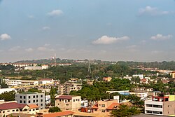 Distant view of Legon Campus (University of Ghana) from East Legon | |
 East Legon | |
| Coordinates: 5°38′10″N0°09′32″W / 5.636°N 0.159°W | |
| Country | Ghana |
| Region | Greater Accra Region |
| District | Ayawaso West Municipal District |
| Time zone | GMT |
| • Summer (DST) | GMT |
East Legon is a town in the Ayawaso West Municipal District of the Greater Accra Region of Ghana. [1]
East Legon has a total area of 4.95 km2 (1.91 mi2) and a total distance of 9.36 km (5.82 mi). It is an 11-minute drive from the Kotoka International Airport and a 38-minute drive from the Tema Harbour. [2]
The Flower Pot interchange was constructed to ease traffic to East Legon. [3]