
William Dampier was an English explorer, pirate, privateer, navigator, and naturalist who became the first Englishman to explore parts of what is today Australia, and the first person to circumnavigate the world three times. He has also been described as Australia's first natural historian, as well as one of the most important British explorers of the period between Sir Francis Drake and Captain James Cook ; he "bridged those two eras" with a mix of piratical derring-do of the former and scientific inquiry of the latter. His expeditions were among the first to identify and name a number of plants, animals, foods, and cooking techniques for a European audience, being among the first English writers to use words such as avocado, barbecue, and chopsticks. In describing the preparation of avocados, he was the first European to describe the making of guacamole, named the breadfruit plant, and made frequent documentation of the taste of numerous foods foreign to the European palate such as flamingo and manatee.
Dampier is a major industrial port in the Pilbara region in the northwest of Western Australia. It is located near the city of Karratha and Port Walcott.

North West Coastal Highway is a generally north-south Western Australian highway which links the coastal city of Geraldton with the town of Port Hedland. The 1,300-kilometre-long (808 mi) road, constructed as a sealed two-lane single carriageway, travels through remote and largely arid landscapes. Carnarvon is the only large settlement on the highway, and is an oasis within the harsh surrounding environment. The entire highway is allocated National Route 1, part of Australia's Highway 1, and parts of the highway are included in tourist routes Batavia Coast Tourist Way and Cossack Tourist Way. Economically, North West Coastal Highway is an important link to the Mid West, Gascoyne and Pilbara regions, supporting the agricultural, pastoral, fishing, and tourism industries, as well as mining and offshore oil and gas production.
Karratha is a city in the Pilbara region of Western Australia, adjoining the port of Dampier. It was established in 1968 to accommodate the processing and exportation workforce of the Hamersley Iron mining company and, in the 1980s, the petroleum and liquefied natural gas operations of the North West Shelf Venture. As of the 2021 census, Karratha had an urban population of 17,013. The city's name comes from the cattle station of the same name, which derives from a word in a local Aboriginal language meaning "good country" or "soft earth". The city is the seat of government of the City of Karratha, a local government area covering the surrounding region.
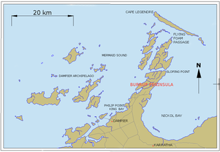
The Dampier Archipelago is a group of 42 islands near the town of Dampier in Pilbara, Western Australia.
Murujuga, formerly known as Dampier Island and today usually known as the Burrup Peninsula, is an area in the Dampier Archipelago, in the Pilbara region of Western Australia, containing the town of Dampier. The Dampier Rock Art Precinct, which covers the entire archipelago, is the subject of ongoing political debate due to historical and proposed industrial development. Over 40% of Murujuga lies within Murujuga National Park, which contains within it the world's largest collection of ancient 40,000 year old rock art (petroglyphs).
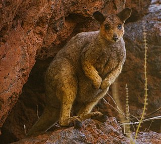
Rothschild's rock-wallaby – sometimes known as the Roebourne rock-wallaby, is a species of macropod found in Western Australia, in the Pilbara district and the Dampier Archipelago. It is not currently considered to be threatened, but is at risk from the red fox.
East Island is an island within the Lacepede Islands group, which sits about 30 kilometres (20 mi) off the coast of the Dampier Peninsula in north-west Western Australia. It is located at 16°54′S122°11′E. It is the site of the East Island Lighthouse. It forms part of the Lacepede Islands Important Bird Area (IBA), so identified by BirdLife International because of its importance for breeding seabirds.

Peron Peninsula is a long narrow peninsula located in the Shark Bay World Heritage site in Western Australia, at about 25°51' S longitude and 113°30' E latitude. It is some 130 kilometres (81 mi) long, running north-northwesterly, located east of Henri Freycinet Harbour and west of Havre Hamelin and Faure Island. It is the largest of the Shark Bay peninsulas. Significant settlements include Denham and Monkey Mia. An airport is located there. It is the location of former Pastoral leases Peron and Nanga stations. It is the main location of land access to points within the World Heritage site. The northern area contains the Francois Peron National Park. It is surrounded by the Shark Bay Marine Park and its lower southeast part is adjacent to the Hamelin Pool Marine Nature Reserve.

The Fortescue River is an ephemeral river in the Pilbara region of Western Australia. It is the third longest river in the state.
Flying Foam Passage is a north-south passage between Angel Island and Dolphin Island in the Dampier Archipelago, near Dampier, Western Australia.
Dolphin Island is an island situated in the Dampier Archipelago in the Pilbara region of Western Australia. Visitors are able to camp within 100 metres (328 ft) of the high water mark on all of the beaches on the island except for the south eastern side.

The Dampier Saltworks Important Bird Area is a 52 km2 saltern lying close to the town of Dampier, an industrial port in the Pilbara region of north-west Western Australia. The salt processing facility is operated by Dampier Salt Ltd, part of the Rio Tinto Group.
The Port Hedland Saltworks Important Bird Area is a 103 km2 tract of originally intertidal land, now containing a saltern, lying about 20 km east of the port of Port Hedland on the coast of the Pilbara region of north-west Western Australia. The salt processing facility is operated by Dampier Salt Ltd, part of the Rio Tinto Group.

Port Hedland is one of the largest iron ore loading ports in the world and the largest in Australia. In 2011 it had the largest bulk cargo throughput in Australia. With the neighboring ports of Port Walcott and Dampier, Port Hedland is one of three major iron ore exporting ports in the Pilbara region of Western Australia,
Main Roads Western Australia controls the major roads in the state's Pilbara region. There are two main highways in the region: Great Northern Highway, which travels north through the region to Port Hedland and then north-west along the coast, as well as North West Coastal Highway, which heads south-west from Port Hedland. A series of main roads connects towns to the highways, and local roads provide additional links. The majority of these roads service the western half of the region, with few located in the various deserts east of the Oakover River. Roads are often named after the towns or areas they connect.

The Pilbara Coast is the coastline of Western Australia's Pilbara region. It is often referred to as the North West Coast of Western Australia.
Intercourse Island is an uninhabited island in the Dampier Archipelago, in the Pilbara region of Western Australia.
East Intercourse Island is an uninhabited island in the Dampier Archipelago, in the Pilbara, Western Australia. It is around 250 hectares in size.
Mistaken Island is an uninhabited island in the Dampier Archipelago, in the Pilbara, Western Australia.
