
Pilbara Iron is a wholly owned subsidiary of the multinational Rio Tinto Group, that manages assets for Hamersley Iron Pty Ltd, a wholly owned subsidiary of Rio Tinto, and Robe River Iron Associates, an unincorporated joint venture between Rio and three Japanese steel companies Mitsui Iron Ore Development P/L (33%), Nippon Steel Australia P/L (10.5%) and Sumitomo Metal Australia P/L (3.5%).
Dampier is a major industrial port in the Pilbara region in the northwest of Western Australia. It is located near the city of Karratha and Port Walcott.
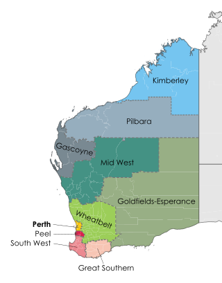
The Pilbara is a large, dry, sparsely populated region in the north of Western Australia. It is known for its Aboriginal people; its ancient landscapes; the prevailing red earth; and its vast mineral deposits, in particular iron ore. It is also a global biodiversity hotspot for subterranean fauna.
Karratha is a city in the Pilbara region of Western Australia, adjoining the port of Dampier. It is located in the traditional lands and waters of the Ngarluma people, for whom it has been Ngurra (home/Country) for tens of thousands of years. It was established in 1968 to accommodate the processing and exportation workforce of the Hamersley Iron mining company and, in the 1980s, the petroleum and liquefied natural gas operations of the Woodside-operated North West Shelf Venture located on Murujuga. As of the 2021 census, Karratha had an urban population of 17,013. The city's name comes from the cattle station of the same name, which derives from a word in a local Aboriginal language meaning "good country" or "soft earth". More recently, Ngarluma people have indicated the name may actually relate to an early interpretation of "Gardarra", stemming from the sacred site for the whale, located in the Karratha area, called "Gardarrabuga". The city is the seat of government of the City of Karratha, a local government area covering the surrounding region.
Pilbara newspapers is a selection of newspapers published in the Pilbara region of Western Australia.

The Hamersley & Robe River railway, majority-owned by Rio Tinto, and operated by its subsidiary Pilbara Iron, is a private rail network in the Pilbara region of Western Australia for the purpose of carrying iron ore. The network is larger than any other Australian heavy freight rail network in private ownership. The total length of its track is about 1,700 km (1,056 mi).

The Brockman 2 mine is an iron ore mine located in the Pilbara region of Western Australia, 60 kilometres north-west of Tom Price.
The Marandoo mine is an iron ore mine located in the Pilbara region of Western Australia, 45 kilometres east of Tom Price.
The Channar mine is an iron ore mine located in the Pilbara region of Western Australia, 17 kilometres south-east of Paraburdoo.
The Eastern Range mine is an iron ore mine in the Pilbara region of Western Australia, 10 kilometres south-east of Paraburdoo.
The Yandicoogina mine, often shortened to Yandi, is an iron ore mine located in the Pilbara region of Western Australia, 95 kilometres north-west of Newman. it should not be confused with BHP Billiton's Yandi mine, which is located nearby.
Cape Lambert is a port facility operated by Rio Tinto Iron Ore in the Pilbara region of Western Australia. It is located 40 kilometres north-east of Karratha.

Iron ore mining in Western Australia, in the 2018–19 financial year, accounted for 54 percent of the total value of the state's resource production, with a value of A$78.2 billion. The overall value of the minerals and petroleum industry in Western Australia was A$145 billion in 2018–19, a 26 percent increase on the previous financial year.
The Yandi mine is an iron ore mine located in the Pilbara region of Western Australia, 90 kilometres north-west of Newman. It should not be confused with Rio Tinto's nearby Yandicoogina mine, which is also sometimes shortened to Yandi.

Port Hedland is one of the largest iron ore loading ports in the world and the largest in Australia. In 2022, it had the largest bulk cargo throughput in Australia. With the neighbouring ports of Port Walcott and Dampier, Port Hedland is one of three major iron ore exporting ports in the Pilbara region of Western Australia.
Port Walcott, formerly known as Tien Tsin Harbour, is a large open water harbour located on the northwest coast of Western Australia, located near the town of Point Samson.
The heavy-haul railways in the Pilbara are a series of company-owned railways in the Pilbara region in the north-west of the state of Western Australia. Their routes total 2782 kilometres.
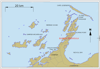
Mistaken Island is an uninhabited island in the Dampier Archipelago, in the Pilbara, Western Australia.
East Mid Intercourse Island is an uninhabited island in the Dampier Archipelago, in the Pilbara, Western Australia. It has an area about 41 hectares ; it is connected by a causeway bridge to the mainland and also to Mistaken Island further out.

Severe Tropical Cyclone Veronica was a large and powerful tropical cyclone which brought major impacts to the Pilbara region of Western Australia during March 2019. The nineteenth tropical low, eighth tropical cyclone and fifth severe tropical cyclone on the 2018–19 Australian region cyclone season, Veronica first appeared as a tropical low near East Timor on 18 March 2019. The system was slow to develop initially while tracking southwestwards through the Timor Sea, but began to consolidate the following day. The storm was upgraded by the Australian Bureau of Meteorology (BOM) to a Category 1 tropical cyclone on the Australian scale at 18:00 UTC on 19 March, by which time a steady development trend had begun. Upon attaining Category 2 status at 06:00 UTC on 20 March, Veronica underwent a period of explosive intensification. The system became a severe tropical cyclone six hours later, and Category 4 just six hours after that. Veronica reached peak intensity at 06:00 UTC the following day as a high-end Category 4 severe tropical cyclone, with ten-minute sustained winds estimated at 195 km/h (120 mph), and a central barometric pressure of 938 hPa. The United States' Joint Typhoon Warning Center estimated that the system was generating one-minute sustained winds of 230 km/h (145 mph), equivalent to a mid-range Category 4 major hurricane on the Saffir-Simpson hurricane wind scale. Veronica proceeded to weaken very gradually over the following few days as it turned towards Western Australia's Pilbara coastline. The system weakened to Category 3 while located just off the Pilbara coast, where it became almost stationary for 24 hours. Veronica began to weaken more quickly as it accelerated westwards on 25 March, tracking parallel to the coast. The system was downgraded below tropical cyclone intensity on 26 March, and after making landfall on North West Cape later that day, the system began to track away from the Australian mainland. Ex-Tropical Cyclone Veronica dissipated on 31 March over the eastern Indian Ocean.
