
The Saint Louis River is a river in the U.S. states of Minnesota and Wisconsin that flows into Lake Superior. The largest U.S. river to flow into the lake, it is 192 miles (309 km) in length and starts 13 miles (21 km) east of Hoyt Lakes, Minnesota. The river's watershed covers 3,634 square miles (9,410 km2). Near the Twin Ports of Duluth, Minnesota and Superior, Wisconsin, the river becomes a freshwater estuary. The lower St. Louis is the only river in the state with whitewater rafting opportunities.
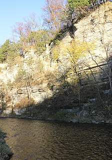
The Root River flows for 80 miles (130 km) through the Driftless Area of southeastern Minnesota and is a tributary of the Upper Mississippi River. The Root River is formed by three branches, the North, South and Middle branches of the Root River and the South Fork Root River. It is an excellent river for canoeing and fishing. The gentle to moderate flowing river drops an average of 3.4 ft/mile from Chatfield, Minnesota, to its pour point in the Mississippi River into Navigation Pool 7 just south of La Crosse, Wisconsin and east of Hokah, Minnesota.

The Nemadji River is a river rising in Pine County, Minnesota, United States, which flows through Carlton County, Minnesota, and Douglas County, Wisconsin, to Lake Superior. The river is 70.8 miles (113.9 km) long measured from its source in Maheu Lake in Pine County, and 34.9 miles (56.2 km) from its confluence with the South Fork in Carlton County just east of the Minnesota-Wisconsin border. The Nemadji River empties into Lake Superior in an industrial neighborhood at Allouez Bay in the city of Superior's east-side neighborhood of Allouez and Wisconsin Point.

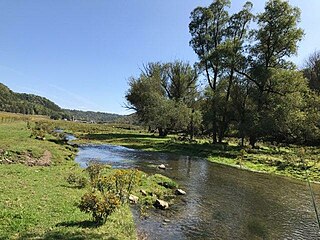
The Vermillion River is a 59.6-mile (95.9 km) waterway that meanders through Scott County and Dakota County in Minnesota, entering the Mississippi River floodplain just south of Hastings. 13.5 miles (21.7 km) of it are designated as a trout stream, which is unusual for being so close to a metropolitan area.

The Whitewater River is a 16.6-mile-long (26.7 km) tributary of the Upper Mississippi River which flows through the Driftless Area of Minnesota, reaching its mouth in Wabasha County at the community of Weaver opposite Buffalo, Wisconsin. The nearest towns are Altura, Saint Charles, and Elba. The region hosts endangered native dry oak savannas, semiforested areas that seem to have been dependent on fire for their well-being.

Hay Creek is a small trout stream in southeastern Minnesota. It has its headwaters west of Goodhue and empties into the Mississippi River just to the north of Red Wing. It runs 25.1 miles (40.4 km). Hay Creek was named for the hay meadows near its banks. A railroad once ran along Hay Creek from the claybanks near Goodhue to the pottery and stoneware factories in Red Wing, which also made use of the water from the creek. The railroad was torn up in 1937, but traces such as trestle pilings remain.

The Baptism River is an 8.8-mile-long (14.2 km) river of the U.S. state of Minnesota. The river source is the confluence of the East Branch Baptism River and the West Branch Baptism River just south of the community of Finland.

The Beaver River is a 23.4-mile-long (37.7 km) river in Lake County, Minnesota. It flows into Lake Superior.
The Blackhoof River is a 26.3-mile-long (42.3 km) tributary of the North Fork Nemadji River in Carlton County, Minnesota, United States, flowing via the Nemadji River to Lake Superior.

The Caribou River is a 15.0-mile-long (24.1 km) river in northern Minnesota, the United States. It rises in a swamp about .6 miles (1 km) south of Morris Lake and two miles (3.2 km) east of Echo Lake, near the Lake/Cook County line, at an altitude about 1620 feet above sea level. It descends some 1,020 feet in elevation as it flows south to its mouth at Lake Superior, also near the eastern border of Lake County.
The Greenwood River is a tributary of the Brule River of Minnesota in the United States. It rises at the outlet of Greenwood Lake and flows south 7.1 miles (11.4 km) to the Brule River.
Lime Creek is a 28.6-mile-long (46.0 km) waterway of Minnesota and tributary of the Des Moines River.
The Little Cannon River is a 30.6-mile-long (49.2 km) river of Minnesota in the United States. It flows into the Cannon River at the city of Cannon Falls. The Little Cannon River is a designated trout stream by the Minnesota Department of Natural Resources.
Pine Creek is a 23.7-mile-long (38.1 km) tributary of the Mississippi River in Winona and Houston counties, Minnesota, United States. Pine Creek joins the Mississippi southeast of La Crescent, Minnesota, directly across from La Crosse, Wisconsin.
The Pine River, also known as the White Pine River, is a 15.0-mile-long (24.1 km) tributary of the Saint Louis River in Minnesota, United States.
Winnebago Creek is a 23.6-mile-long (38.0 km) tributary of the Mississippi River in southeastern Minnesota.

The Manitou River is a 24.9-mile-long (40.1 km) river in northern Minnesota, which drains into Lake Superior along its north shore about three miles northeast of Little Marais. It flows southeast through the Superior National Forest, Finland State Forest, and George H. Crosby Manitou State Park in Lake County.
Belle Creek is a trout stream in Goodhue County, in the U.S. state of Minnesota. It is a tributary of the Cannon River.
Pine Creek is a stream in Fillmore and Winona counties, in the U.S. state of Minnesota. It is a tributary of the Rush Creek, which is a tributary of the Root River. It joins the Rush Creek in the extreme north of Rushford, Minnesota. Tributaries of Pine Creek are Cooledge Creek and Hemmingway Creek.
