Ebano Verde Scientific Reserve

Last updated
Ebano Verde Scientific Reserve
Magnolia pallescens.jpg
Ebano Verde ( Magnolia pallescens ) flower, endemic to the region and namesake of the Reserve
LocationJarabacoa, La Vega, Dominican Republic
Nearest cityLa Palma, Constanza, La Vega Province
Coordinates 19°03′31″N70°32′39″W / 19.0585°N 70.5443°W / 19.0585; -70.5443
Area29 km2 (11 sq mi)
Average elevation1,119 m
Max. elevation1,549 m
Min. elevation585 m
EstablishedOctober 26, 1989

The Ebano Verde Scientific Reserve in the Dominican Republic was created on October 26, 1989 by Decree No. 417-89, Environment and Resources General Law 64-00, ratified by the Protected Areas Sectorial Law No. 202-04, ordered by then President Joaquin Balaguer.  

Contents

Ebano Verde is the first in the nation to be administrated by the private Foundation for Human Betterment (Fundacion para el Mejoramiento Human) Progressio, that was established to guarantee the maintenance of the Cibao's hydric standards, assists with the preservation of the 29 km2 area designated to the reserve, an area which has expanded since the original 23 km2.

The reserve is located on the eastern region of the Cordillera Central in the Province of La Vega and Monseñor Nouel, within the municipalities of Jarabacoa, Bonao, and Constanza, Dominican Republic.

The Ebano Verde ( Magnolia pallescens ) tree is a forest species that is endemic to the Dominican Republic and thrives exclusively in the Bosque Nublado (Clouded Forest), classified as a Very humid Lower Montane Forest (Bmh-MB). [1] [2]

History

Ebano Verde Scientific Reserve Location Ebano verde Map screenshot.png
Ebano Verde Scientific Reserve Location

President of the Collado Foundation, Dr. Mario Collado, solicited the approval of the exploitation of Ebano Verde (Green Ebony) dead wood, due to the devastation that occurred on his property from Hurricane David and Tropical Storm Federico on the hills of La Golondrina and La Sal in the Cordillera Central. In order to extract the wood from the area, a system of thousands of cables had to be developed and installed that would not alter the ecological structure of the zone, and haul the dead lumber to the main roads. The King World Wide Company of Miami Florida had received news via Fax, of the existence of over 25,000,000 (25 Million) feet of lumber to be extracted.

On July 3, 1992, by order 15791 to the General Director of Forestry, Balaguer gave the authorization to Dr. Collado Laboratories to perform a removal and exploitation of the dead lumber of the Ebano (ebony) species, with 40% of the proceeds to Dr. Collado Laboratories and 60% to the Dominican State. A few days later of July 7, 1992, Balaguer formed a commission for the supervision, control, and exploitation of the dead lumber.

The Dominican Forestry Directorate was under much pressure, due to the amount of interests that would be generated from this project. There was only one signature left for the approval, that of the Director of Forestry, after all of the members of the commission had given their approval, when President Balaguer received news that the Secretary of Public Works had a tractor in the area, for the reparation of the neighboring road that leads to Palma de Constanza and unto Loma de la Golondrina, which hindered the extraction of wood. Balaguer's response was: "That has no validity, rejected, and set the tractor on fire".  

Immediately, Secretary Eduardo Estrella of Public Works had been notified to remove the equipment that was at work in the Scientific Reserve, by orders of President Balaguer, ending the discussion and moving forward with the extraction. [3]

Geography

Hills

Located northwest of Casabito in Jarabacoa, Loma de la Golondrina (eng. Swallow Hill) is the highest elevation in the area, reaching 1,549 m above sea level, and according to the Holdrige System, vegetative life within the reserve is that of a very humid Lower Montane Forest (Bmh-MB), making it one of the most humid areas in the Dominican Republic.

The territory of Las Neblinas within the scientific reserve is made up of a geological formation denominated as Tireo, characterized as magmatic rocks and volcanic sediments from the superior Cretaceous period. The highest areas found in Las Neblinas are Loma La Lomita (1,182 m), Montellano (1,439 m), Prieta (1,023 m), Casabito (1,453 m), and La Sapa (1,230 m). [4]

Rivers and streams

The hydrography of the Scientific Reserve and the surrounding areas are ones of great ecological importance, as Ebano Verde's La Sal, Bonito, and Arroyazo streams and water basins feed the rivers of Jimenoa, Camu, Jatubey, La Gina, Masipedro, Tireo and Tireito, La Piedra, Blanco, Pinar Bonito, Grande, and Palero, which supply the city of La Vega and the Tavera and Rincon Dams. [5]

Trails

Within the Reserve are various trails and pathways, two of which are permitted to visitors: Sendero Baño de Nubes or Las Nubes (the clouds), and Sendero La Sal (the salt), descending through forests of Palo de Viento ( Frodinia tremula ) in between the hills that are covered with thick Fern of different species, including the Cyathea and Dicranopteris genus, leading to streams that are lined with Manacla or Palma de Sierra ( Prestoea montana ), comprising the areas of vegetation known as "Manaclares".

The only way to get through the Reserve is by hiking, due to the prohibition of animals such as horses and mules, which contaminate the soil with their droppings, eating and trampling over prohibited vegetation. [6]

Climate

Ebano Verde is an area with heavy downpour, classified as high tropical mountain climate, with a registered amount of rainfall at 2,327 mm to 4,633 mm with an annual average of 3,853 mm. The lowest temperatures reach 11,4°C and a maximum of 20.4°C, with an average temperature of 16.3°C.

Flora and fauna

Flora

According to reports, the flora in this natural protected area are made up of 621 species of vascular plants, of which 153 are highly endemic to La Hispaniola. The most prominent endemic species of flora that abounds in the area is the Ebano Verde (Green Ebony), Magnolia pallescens, a highly endangered precious wood tree.

Also extremely important, are the rarely mentioned species of Pinguicula casabitoana (a carnivorous plant), Gonocalyx tetraptera, Gesneria sylvicola , Lyonia alaini , and Myrcia saliana , as well as the palo de viento ( Frodinia tremula ), jaiqui ( Bumelia salicifolia ), pino criollo ( Pinus occidentalis ), sangre de pollo ( Mecranium amigdalinum ), and the palo santo ( Alpinia speciosa ). [7]

Fauna

The Reserve's herpetofauna is composed of eight species of amphibians and ten species of reptiles. Among the mammals found are bats such as the Mexican free-tailed bat and the Hispaniolan solenodon, laying on the edge of extinction. [7]

Some of the prominent birds within the Reserve are the cuca Hispaniolan amazon, Hispaniolan parakeet, limpkin (Aramus guarana elecus), ruddy quail-dove and the endangered rufous-collared sparrow.

In addition to these, other species include the Antillean euphonia, black-faced grassquit, Hispaniolan spindalis, yellow-throated warbler, black-throated blue warbler and black-throated green warbler, Cape May warbler, golden swallow, Hispaniolan emerald, Hispaniolan trogon, white-collared swift, plain pigeon, sharp-shinned hawk, Eastern chat-tanager, and greater Antillean elaenia. [8]

Related Research Articles

<span class="mw-page-title-main">Pico Duarte</span>

Pico Duarte is the highest peak in the Dominican Republic, on the island of Hispaniola and in all the Caribbean. At 3,101 m (10,174 ft) above sea level, it gives Hispaniola the 16th-highest maximum elevation of any island in the world. Additionally, it is only 85 kilometres northeast of the region's lowest point, Lake Enriquillo, 46 m below sea level. It is part of the Cordillera Central range, which extends from the plains between San Cristóbal and Baní to the northwestern peninsula of Haiti, where it is known as the Massif du Nord. The highest elevations of the Cordillera Central are found in the Pico Duarte and Valle Nuevo massifs.

<span class="mw-page-title-main">Hispaniolan pine forests</span>

The Hispaniolan pine forests are a subtropical coniferous forest ecoregion found on the Caribbean island of Hispaniola, which is shared by Haiti and the Dominican Republic. The ecoregion covers 11,600 km2 (4,500 sq mi), or about 15% of the island. It lies at elevations greater than 800 m (2,600 ft) in the mountains of Hispaniola, extending from the Cordillera Central of the Dominican Republic and into the Massif du Nord of Haiti. It is surrounded at lower elevations by the Hispaniolan moist forests and Hispaniolan dry forests ecoregions, which cover the remainder of the island. Annual rainfall is 1,000–2,000 mm (39–79 in).

<span class="mw-page-title-main">Jarabacoa</span> Place in La Vega, Dominican Republic

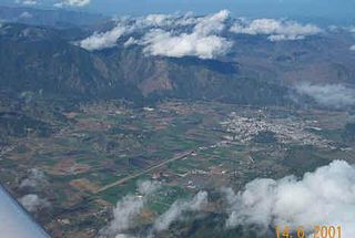
Jarabacoa is a town located in the central region of the Dominican Republic. It is the second largest municipality in La Vega Province.

<span class="mw-page-title-main">Yaque del Norte River</span> River in the Dominican Republic

The Yaque Del Norte River is the longest river in the Dominican Republic, as well as the second longest river on Hispaniola, behind the Artibonite River. It is 296 km long and flows northwest into the Atlantic Ocean.

<span class="mw-page-title-main">Constanza, Dominican Republic</span> Place in La Vega, Dominican Republic

Constanza is a town and municipality in La Vega Province, Dominican Republic. Located in the Cordillera Central region, Constanza is known for having the coldest temperature for a settlement on the island of Hispaniola, as well as the entire Caribbean.

<span class="mw-page-title-main">White-winged warbler</span> Species of bird endemic to Hispaniola

The white-winged warbler, also called the white-winged ground-warbler or Hispaniolan highland-tanager, is a Vulnerable species of bird of the family Phaenicophilidae, the Hispaniolan tanagers. It is endemic to the island of Hispaniola which is shared by Haiti and the Dominican Republic.

Huautla de Jimenez is a town and municipality in the Mexican state of Oaxaca. It is part of the Teotitlán District in the north of the Cañada Region.

<span class="mw-page-title-main">Los Haitises National Park</span> National park in the Dominican Republic

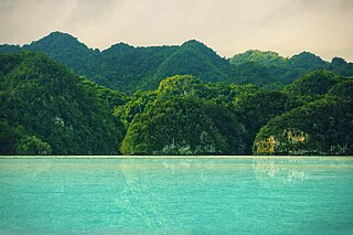
Los Haitises National Park is a national park located on the remote northeast coast of the Dominican Republic that was established in 1976. It consists of a limestone karst plateau with conical hills, sinkholes and caverns, and there is a large area of mangrove forest on the coast. Other parts of the park are clad in subtropical humid forest and the area has an annual precipitation of about 2,000 mm (79 in). The park contains a number of different habitats and consequently has a great diversity of mammals and birds, including some rare species endemic to the island. Some of the caverns contain pictograms and petroglyphs. The park has become a popular ecotourism destination but the number of tourists allowed to visit is limited.

<span class="mw-page-title-main">Allpahuayo-Mishana National Reserve</span>

Allpahuayo-Mishana National Reserve is a protected area in Peru located southwest of Iquitos in the region of Loreto. It was established in 2004 to protect the diverse forest types in the area, especially the rainforests on white sandy soil and watercourses which provide drinking water to the city of Iquitos.

Cerulean Warbler Bird Reserve, known in Spanish as Reserva Natural de las Aves Reinita Cielo Azul, is a nature reserve near Bucaramanga in central Colombia. The reserve is set among oak forest on the eastern slopes of the Magdalena River. It measures 545 acres (221 ha) and adjoins the Yariguíes National Park.

<span class="mw-page-title-main">Hispaniolan moist forests</span> Ecoregion on Hispaniola

<span class="mw-page-title-main">Wildlife of Haiti</span>

The wildlife of Haiti is important to the country because of its biodiversity. According to the World Conservation Monitoring Centre, Haiti is considered to be "one of the most biologically significant countries of the West Indies". With an estimated 5,600 plant species on the island of Hispaniola, some of which only occur in Haiti, 36% are considered as endemic to the island. A mountainous area country, it is situated in the western three-eighths of Hispaniola and shares a border with the Dominican Republic. There are nine life zones, from low desert to high cloud forests, as well as four mountain ranges, and hundreds of rivers and streams and the coral reefs in the seas that surround the islands. Issues of environmental damage, expanding population, deforesting and erosion are of concern; less than 2% of the original forest remains on account of deforestation. This degradation is traced from the 17th century to 19th century starting with the French colonization of the Haiti and population explosion during the 20th century and for the purpose of forestry and sugar-related industries, degraded the forests. and the environment.

<span class="mw-page-title-main">Faia Brava</span> Natural reserve in northern Portugal

Faia Brava is a natural reserve in northern Portugal. It is the first privately owned natural reserve in the country.

<span class="mw-page-title-main">Sierra de Bahoruco National Park</span>

The Sierra de Bahoruco National Park is an environmentally protected national park located in the South-western region of Dominican Republic. It was created in 1983 by Presidential Decree during the presidency of Salvador Jorge Blanco.

<span class="mw-page-title-main">Hispaniolan dry forests</span> Ecoregion on Hispaniola

The Hispaniolan dry forests are a tropical dry broadleaf forest ecoregion on the island of Hispaniola. They cover 15,123 km2 (5,839 sq mi), around 20% of the island's area.

<span class="mw-page-title-main">Planadas-Yeyesa Nature Reserve</span> Protected nature reserve located in Puerto Rico

The Planadas-Yeyesa Nature Reserve is a protected nature reserve located in the Sierra de Cayey, in the municipality of Salinas in central Puerto Rico. The reserve is located close to the famous Cerro Las Tetas. Two of the most prominent features of the reserve are Cerro Planada, a 2,480 feet high mountain peak, and La Yeyesa, a heavily forested canyon formed by the Lapa River and other streams which feed into the Nigua River. La Yeyesa can be accessed through a lightly trafficked yet moderate trail.

<span class="mw-page-title-main">Isla Verde Reef</span>

Isla Verde Reef is a reef that surrounds Isla Verde Key, located off the coast of Punta del Medio in Isla Verde, Carolina, in the Atlantic coast of Puerto Rico. The Isla Verde Reef, protected as the Isla Verde Reef Marine Reserve, forms part of a larger reef system that extends from Punta Maldonado in Piñones, Loíza to the San Juan Islet. This is one of the three designated marine reserves in Puerto Rico, the other two being the Desecheo Coastal Waters and Tres Palmas marine reserves off the western coast of Puerto Rico, and the only one that protects a coral reef ecosystem on an urban area. The reserve is home to endangered species such as manatees, sea turtles and federally protected coral species such as the elkhorn coral. The coral reef is also an ideal place for fish spawning which is important for the fishing industry of the region. The Isla Verde Reef is protected through community organizations such as Arrecifes Pro Ciudad, and public organisms such as Para la Naturaleza, with support from academic institutions such as the University of Puerto Rico at Bayamón.

References

  1. "Jardín Botánico Nacional | JBN - Imparten taller sobre la conservación de Las Magnolias en el Jardín Botánico". www.jbn.gob.do (in Spanish). Retrieved 2021-12-09.
  2. "Reserva científica de Ébano Verde, Jarabacoa". www.visitarepublicadominicana.org. Retrieved 2021-12-09.
  3. "Balaguer y el ébano verde". El Día. 2016-11-21. Retrieved 2021-12-09.
  4. "Foro Nacional de Areas Protegidas". foronacionaldeareasprotegidas.blogspot.com (in Spanish). Retrieved 2021-12-09.
  5. "Informacion sobre la Reserva Cientifica Ebano Verde". Explora Dominicana (in Spanish). 2008-12-04. Retrieved 2021-12-09.
  6. "Mitos y realidades de Ébano Verde y Campamento La Sal". Mitos y realidades de Ébano Verde y Campamento La Sal. Retrieved 2021-12-09.
  7. 1 2 eugenio (2020-06-16). "Reserva Científica Ébano Verde". Eco-Hispaniola. Retrieved 2021-12-09.
  8. "Ebano Verde Reserve". Caribbean Birding Trail. Retrieved 2021-12-09.