Eccles, Scottish Borders

Last updated

Eccles Kirk.jpg

Eccles (Scottish Gaelic : An Eaglais. Brythonic/Welsh: Eglwys) is a village and agricultural parish near Kelso in Berwickshire in the Scottish Borders area of Scotland. The village is conjoined with Birgham and Leitholm.

Contents

Etymology

Like other 'Eccles'-names in Britain, this is taken to derive from the Brittonic word which survives in Welsh as eglwys 'church'. [1] The word was originally borrowed into Brittonic from Latin ecclesia.

History

It is said that there was a Christian enclave at Eccles in the 6th century or possibly before. Watson gives the derivation as most likely from the Welsh (or Cumbric) eglwys meaning church [2] and places with this name element are thought to indicate ancient Christian sites. Gospatric, Earl of Dunbar (or his wife) founded St. Mary's Cistercian convent at Eccles in 1156.

Regent Albany stayed at Eccles Priory in November 1522 during an unsuccessful siege of Wark Castle. [3] It was burnt by the Earl of Hertford's forces in 1545, then laicised to the Home family. Only two barrel-vaulted cells of the east range at the west end of the churchyard survive as well as architectural fragments built into later garden walls, although the parish church, rebuilt in 1774, may include some mediaeval stones. [4] [5] Patrick I, Earl of Dunbar, who died on 31 December 1232, was interred in the convent at Eccles.

Lairds

The principal landed proprietors in the vicinity of Eccles in 1696 appears to have been George Home of Kames (which is situated towards Birgham) who had 9 hearths, Purves Hall, then occupied by Marjory Flemming, had twelve hearths, and Simon Marjoribanks of Stainrig who had six. (Purveshall and Stainrig are closer to Leithholm than Eccles). [6] In 1843 it was James Greig who resided at Eccles House, which abuts the village. [7]

Kirk

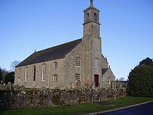
The Church of Scotland Parish Church, rebuilt in 1774, is a large 5-bay building with some stained glass windows (notably the 'War Memorial Window') in 'Gothick' glazing-patterned sashes in round-headed openings. There is a vernacular bell-tower at the east end holding a bell dated 1659. The last additions and internal alterations were carried out in 1930. [8] The earliest Presbyterian Minister appears to be Robert French, who was at Eccles from 1567 to 1574. [9] The Reverend John Lauder, who had previously been the incumbent at Lilliesleaf, was ordained into Eccles 28 May 1691, when objectors opposed to him interrupted the ceremony. Two of these were Richard Edgar of Newtoun, (an Episcopalian and opposed to the government of William & Mary), and Henry Home of Kames. [10] Reverend Lauder from Eccles was a member of the General Assembly in 1692. On Sunday 31 March 1695 Mr. Lauder was not present at Eccles to take the service, he "being sent to preach in the north as is ordered by the last Assembly that every Presbytery should send so many quarterly there." [11] He was succeeded at Eccles by the Reverend Matthew Dysart MA, on 9 September 1729, Lauder having died in July that year. [12] Dysart remained the incumbent at Eccles for a staggering forty three years. [9]

Today Eccles is conjoined with the parishes of Birgham and Leitholm. [13]

Notable residents

The village was also mentioned in Wolfbloods Dark rune episode.

See also

Notes

  1. Bethany Fox, 'The P-Celtic Place-Names of North-East England and South-East Scotland', The Heroic Age, 10 (2007), http://www.heroicage.org/issues/10/fox.html (appendix at http://www.heroicage.org/issues/10/fox-appendix.html).
  2. Watson, W. J. (1926): History of the Celtic Place-Names of Scotland, Edinburgh: Edinburgh University Press
  3. Ken Emond, The Minority of James V (Edinburgh, 2019), p. 175.
  4. Strang, Charles Alexander, Berwick and Borders, Edinburgh, 1994, p.62, ISBN   1-873190-10-7
  5. Oman (1995) p.56 and 122
  6. Ewan, Elspeth, editor, Eccles, Leitholm & Birgham. Berwickshire Monumental Inscriptions, 5. Borders Family History Society, 1998. ISBN   1-874232-01-0 . p.2 - 7, 1696 Hearth Tax.
  7. Findlay, James, Directory to Gentleman's Seats, Villages, &c., in Scotland, Edinburgh, 1843, p.52
  8. Strang (1994) p.62
  9. 1 2 Ewan (1998) p.8
  10. Genealogical Collections Concerning The Scottish House of Edgar, The Grampian Club, London, 1873, p.9
  11. Kelsall, Keith & Helen, An Album of Scottish Families 1694-96, Aberdeen University Press, 1990.
  12. Anderson, Rev. John, editor, Calendar of the Laing Charters, 854-1837, Edinburgh, 1899, page 716, number 3114.
  13. Ewan (1998)

55°39′58″N2°22′30″W / 55.666°N 2.375°W / 55.666; -2.375

Related Research Articles

<span class="mw-page-title-main">Berwickshire</span> Historic county in Scotland

Berwickshire is a historic county, registration county and lieutenancy area in south-eastern Scotland, on the English border. The county takes its name from Berwick-upon-Tweed, its original county town, which was part of Scotland at the time of the county's formation in the twelfth century, but became part of England in 1482 after several centuries of swapping back and forth between the two kingdoms. After the loss of Berwick, Duns and Greenlaw both served as county town at different periods.

<span class="mw-page-title-main">Lauder</span> Town in Scottish Borders, Scotland, UK

The former Royal Burgh of Lauder is a town in the Scottish Borders in the historic county of Berwickshire. On the Southern Upland Way, the burgh lies 27 miles (43 km) southeast of Edinburgh, on the western edge of the Lammermuir Hills.

<span class="mw-page-title-main">Duns, Scottish Borders</span> Human settlement in Scotland

Duns is a town in the Scottish Borders, Scotland. It was the county town of the historic county of Berwickshire.

<span class="mw-page-title-main">Greenlaw</span> Town in the Scottish Borders

Greenlaw is a town and civil parish situated in the foothills of the Lammermuir Hills on Blackadder Water at the junction of the A697 and the A6105 in the Scottish Borders area of Scotland. At the 2001 census, the parish had a population of 661.

<span class="mw-page-title-main">Coldingham</span> Village and parish in Scotland

Coldingham is a village and parish in Scottish Borders, on Scotland's southeast coastline, north of Eyemouth.

<span class="mw-page-title-main">Blackadder Water</span> A river in Berwickshire, Scotland

Blackadder Water is a river in Berwickshire in the Scottish Borders area of Scotland, forming part of the River Tweed system. It reached 2.84m at Mouthbridge, which was its highest level ever recorded on Tuesday 22 October 2002 at 2:45pm.

<span class="mw-page-title-main">Earlston</span> Human settlement in Scotland

Earlston is a civil parish and market town in the county of Berwickshire, within the Scottish Borders. It is on the River Leader in Lauderdale, Scotland.

<span class="mw-page-title-main">Foulden, Scottish Borders</span> Human settlement in Scotland

Foulden is a civil parish and village in the Berwickshire area of Scottish Borders, Scotland, situated not far above the Whiteadder Water, and 7 miles (11 km) west of Berwick-upon-Tweed.

<span class="mw-page-title-main">Oxton, Scottish Borders</span> Human settlement in Scotland

Oxton is a small rural village in the Scottish Borders area of Scotland, just off the A68. It is 4+12 miles north of Lauder, and 20 mi (32 km) southeast of the centre of Edinburgh, yet in a quiet rural position.

Eden Water is a tributary of the River Tweed in the Scottish Borders of Scotland. "Water" is the Lowland Scots term for a small river.

<span class="mw-page-title-main">Birgham</span> Village in Scottish Borders, Scotland, UK

Birgham is a village in Berwickshire, parish of Eccles in the Scottish Borders area of Scotland, near Coldstream and the River Tweed, on the A698. Birgham is close to Ednam, Kelso, Lempitlaw, Leitholm and Sprouston as well as Carham and Wark on Tweed, Northumberland.

Ladykirk is a village on the B6470 in the Scottish Borders area of Scotland, and the former Berwickshire, just north of the River Tweed and the Anglo-Scottish border. The town was formerly known as Upsettlington, but King James IV of Scotland renamed the town Ladykirk; the church is also known as St Mary's Church or Kirk of Steill. Ladykirk stands directly opposite Norham Castle, Northumberland, England

Fogo is a village in the county of Berwickshire, in the Borders of Scotland, 3 miles south of Duns, on the Blackadder Water.

<span class="mw-page-title-main">Preston, Scottish Borders</span> Human settlement in Scotland

Preston is a small village in the ancient county of Berwickshire, now an administrative area of the Scottish Borders region of Scotland. It lies within the local Abbey St Bathans, Bonkyl & Preston Community Council area.

Leitholm is a village in the Scottish Borders area of Scotland, 4 miles (6.4 km) north-west of Coldstream, in the former county of Berwickshire.

<span class="mw-page-title-main">Edrom</span> Human settlement in Scotland

Edrom is a parish and small village in the pre-1975 ancient county of Berwickshire, now an administrative area of the Scottish Borders region of Scotland.

Allanbank is a village near Allanton, in the Scottish Borders area of Scotland, in the historic county of Berwickshire.

<span class="mw-page-title-main">Cranshaws</span> Village in Scottish Borders, Scotland, UK

Cranshaws is a village on the B6355 road, near Duns, in the Scottish Borders area of Scotland, in the former Berwickshire.

<span class="mw-page-title-main">Crosshall cross</span>

The Crosshall Cross is a cross at Crosshall Farm, Eccles, in the Scottish Borders area of Scotland, in historic Berwickshire.

<span class="mw-page-title-main">Ettleton</span> Village in Scottish Borders, Scotland, UK

Ettleton is a village near Castleton, in the Scottish Borders area of Scotland, in the former Roxburghshire.