Eden Hot Springs

Last updated

Eden Hot Springs
Canadian Springs
Rancho Grande
Eden Hot Springs circa 1898.jpg
Eden Hot Springs and San Jacinto mapped c.1898
Eden Hot Springs
Coordinates 33°53′46″N117°03′25″W / 33.896°N 117.057°W / 33.896; -117.057 [1]
Elevation1,690 feet (520 m)
Type geothermal
Discharge114 liters/minute [2]
Temperature43 °C (109 °F) [2]

Eden Hot Springs was a historic hot springs and resort in Riverside County, California, United States.

Contents

History

Before settlement, there was a village of Serrano people at what came to be called Eden Springs. [3] One report states that "in little valley south of Eden Hot Springs and west of Mt. Eden [there were] three camps with midden deposits in addition to a mill. This location was probably used only during a limited portion of the year." [4]

Eden, the northernmost of the three hot springs along the San Jacinto fault, had a resort as early as the 1890s. [5] The entrance to the springs property was said to be located at the corner of the Joe Aigurrie ranch along San Jacinto highway [6] and/or south of the so-called Jackrabbit Trail road. [7] [8] In the 1900s and 1910s, Eden Springs was owned by James B. Glover (a San Bernardino County supervisor known for his development of roads and water resources) and managed by his son-in-law Frank A. Armstrong. [9] [10] Circa 1904, "conveyances for Eden" left from the Star Grocery in Redlands every Wednesday and Saturday at 3 p.m. [11] Picture postcards show that in the early 1900s there was a one-story hotel, cottages, changing rooms, and a bathhouse with an open outdoor "cistern". [5]

USGS photo of mountains near Eden Hot Springs Eden Hot Springs 1917 USGS photo.jpg
USGS photo of mountains near Eden Hot Springs

As of 1908, "cottages and tents provided accommodations for about 50 people, and a bathhouse and small swimming pool allowed use of the water for bathing". [12] Bottled water from the springs was sold under the labels Iron Lithia and White Sulphur. [12] In 1910, a newspaper reported "The property contains 640 acres of rolling foothill land, a large portion of which is tillable. The 30 or 40 mineral springs furnish a flow of 25 inches, which can be used for irrigation purposes. Already a small orchard of different varieties of deciduous fruits has been planted, as well as a vineyard. Among the improvements are a new pavilion, a large cement plunge, several bath houses, a number of new cottages, and a dining room". [13] J. B. Glover died in 1921, [14] and F. A. Armstrong took charge in 1922. [15] In 1926, Frank and Virgie L. Armstrong sold the property to investors from Los Angeles. [16]

"New Guest House at Eden Hot Springs" designed by S. Charles Lee New Guest House at Eden Hot Springs 1929 S. Charles Lee.jpg
"New Guest House at Eden Hot Springs" designed by S. Charles Lee

In 1929 the investment group that had acquired the site commissioned California architect S. Charles Lee to design new resort facilities. Lee told an interviewer many years later, "We built a hotel and bungalows and all the appurtenances to a hot springs hotel". [17] At that time, Lee used a private plane to travel to the dozen or so commissions he had in the Southland, including the fairly remote Eden Springs. [17] The California Spanish Colonial Revival-style hotel was said to be set upon a "mesa" overlooking the canyon and the valley beyond. [18] At that time the site was said to have 23 "medicinal springs". [18] However, the Great Depression was at hand, and according to one account, "during the 1930s all the hot springs in the San Jacinto valley dried up". [5] The property changed hands several times, [6] [19] until eventually a man named Axel Springboard took it over and ran it somewhat successfully in the period immediately before and during World War II. [20] The resort was rebranded Keith's Rancho and then Rancho Grande, [21] [22] and eventually closed in 1946. [23]

When sold at auction in 1952, Eden Hot Springs was said to be 654 acres, with a "two-story main hotel with 14 suites, an adjoining building with 12 suites, a dining room and kitchen structure, a bathhouse, five cottages and a swimming pool". [23] [24] It was then renamed Canadian Springs and was used as a "weekend facility", eventually closing again in 1958. [20] [25]

Eden Springs was evacuated but saved from destruction during the 1975 Badlands fire, [26] stood empty and was sold to new owners in 1977, and was destroyed in an arson fire in 1979. [20]

Fossils

Eden Hot Springs resort was the only access route to a fossil find in San Timoteo Badlands, which was excavated under the sponsorship of Childs Frick from 1916 to 1921. [9] [27] Fossils found in the San Timoteo and Mt. Eden Formations included mastodons, ground sloths, a three-toed horse, a giraffe-camel, a very small camel, and a cave bear. [28]

Water profile

According to an U.S. government survey of California springs first published in 1915, "Eight small springs rise within a distance of 100 yards at the base of a steep granitic slope. The water issues less than 200 yards beyond the southeastern border of a series of shales and sandstones of Tertiary age, in which there are dislocations that were probably caused by the uplift of the San Jacinto Range; but the springs seem not to be related causally to the sediments. The maximum temperature of the water is about 110 °F (43 °C). It is moderately sulphureted but does not seem to be otherwise notably mineralized". [12] [29]

USGS mineral analysis and classification of waters in the San Jacinto Basin, 1917 Mineral springs in the San Jacinto Basin.jpg
USGS mineral analysis and classification of waters in the San Jacinto Basin, 1917

See also

Related Research Articles

<span class="mw-page-title-main">San Bernardino Valley</span> Valley in California, United States

The San Bernardino Valley is a valley in Southern California located at the south base of the Transverse Ranges. It is bordered on the north by the eastern San Gabriel Mountains and the San Bernardino Mountains; on the east by the San Jacinto Mountains; on the south by the Temescal Mountains and Santa Ana Mountains; and on the west by the Pomona Valley. Elevation varies from 590 feet (180 m) on valley floors near Chino to 1,380 feet (420 m) near San Bernardino and Redlands. The valley floor is home to over 80% of the more than 4 million people in the Inland Empire region.

Gilman Hot Springs is an unincorporated community in Riverside County, California. It lies along California State Route 79, adjacent to the San Jacinto campus of Mt. San Jacinto College.

<span class="mw-page-title-main">Mercey Hot Springs</span> Unincorporated community in Fresno County, California

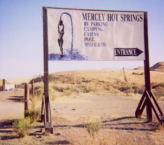
Mercey Hot Springs is an unincorporated community and historical hot springs resort in the Little Panoche Valley of Fresno County, central California, about 60 miles (97 km) west-southwest of Fresno.

<span class="mw-page-title-main">San Timoteo Canyon</span> Landform in Riverside and San Bernardino Counties, California

San Timoteo Canyon is a river valley canyon southeast of Redlands, in the far northwestern foothills of the San Jacinto Mountains in the Inland Empire region of Southern California.

The Badlands are a mountain range in Riverside County, California. They are also known as the San Timoteo Badlands. The range trend northwest–southeast with the San Jacinto Valley to the southwest, the San Timoteo Canyon to the northeast and the San Jacinto Mountains to the east. These mountains separate the cities of Beaumont and Moreno Valley. The mountains are crossed by California State Route 60, California State Route 79, and a handful of smaller roads.

<span class="mw-page-title-main">Scovern Hot Springs</span> Former settlement in California, United States

Scovern Hot Springs is a thermal spring system, and former settlement in the Kern River Valley of the Southern Sierra Nevada, in Kern County, California.

<span class="mw-page-title-main">Castle Rock Springs, California</span> Unincorporated community in California, United States

Castle Rock Springs was a resort Lake County, California built around a group of mineral springs, including one hot spring with relatively high volumes of water.

<span class="mw-page-title-main">Gilman Hot Springs</span> Thermal springs in California

Gilman Hot Springs, also known as San Jacinto Hot Springs or the Relief Springs, is a hot spring system in the Inland Empire area of Southern California. Located near Potrero Creek, the San Jacinto River, and California State Route 79, the springs system consists of "about half a dozen" springs named for the Mexican land grant Rancho San Jacinto Viejo.

Rancho San Jacinto y San Gorgonio was a 4,440-acre (18.0 km2) Mexican land grant in present-day Riverside County, California given in 1843 by Governor Manuel Micheltorena to James (Santiago) Johnson. At the time of the US Patent, Rancho San Jacinto y San Gorgonio was a part of San Bernardino County. The County of Riverside was created by the California Legislature in 1893 by taking land from both San Bernardino and San Diego Counties. The grant encompassed San Timoteo Canyon.

The Inland Feeder is a 44 mi (71 km) high capacity water conveyance system that connects the California State Water Project to the Colorado River Aqueduct and Diamond Valley Lake. The Metropolitan Water District of Southern California designed the system to increase Southern California's water supply reliability in the face of future weather pattern uncertainties, while minimizing the impact on the San Francisco Bay/Sacramento–San Joaquin River Delta environment in Northern California. The feeder takes advantage of large volumes of water when available from Northern California, depositing it in surface storage reservoirs, such as Diamond Valley Lake, and local groundwater basins for use during dry periods and emergencies. This improves the quality of Southern California drinking water by allowing more uniform blending of better quality water from the state project with Colorado River supplies, which has a higher mineral content.

<span class="mw-page-title-main">Seminole Hot Springs, California</span> Unincorporated community in California, United States

Seminole Hot Springs is an unincorporated community in Los Angeles County, California, United States. Seminole Hot Springs is located in the Santa Monica Mountains near Cornell, 3.6 miles (5.8 km) south-southeast of Agoura Hills at an elevation of 932 feet (284 m).

<span class="mw-page-title-main">San Timoteo Creek</span> River in the southern California, US

San Timoteo Creek is a stream in Riverside and San Bernardino counties in southern California, United States. A tributary of the Santa Ana River, it flows through San Timoteo Canyon. San Timoteo Creek has a drainage basin of about 125 square miles (320 km2). The creek receives most of its water from headwater tributaries flowing from the San Bernardino Mountains near Cherry Valley, as well as Yucaipa Creek, which flows from Live Oak Canyon.

The Mt. Eden Formation is a geologic formation in Riverside County, California. It underlies the San Timoteo Formation, and preserves fossils dating back to the Neogene period.

<span class="mw-page-title-main">Bimini Baths</span> Los Angeles natatorium (1903–1951)

Bimini Baths was a geothermal mineral water public bathhouse and plunge in what is now Koreatown, Los Angeles, California, US. It was situated just west of downtown, near Third Street and Vermont Avenue. Bimini Baths contained a natatorium, swimming pools, swimming plunge, Turkish baths, a medical treatment department, and bottling works.

<span class="mw-page-title-main">Reche Canyon</span> Canyon in southern California, United States

Reche Canyon is a canyon in the far northwestern foothills of the San Jacinto Mountains, northwest of The Badlands in the Inland Empire region of Southern California. The Tongva village of Homhoangna, from which the canyon's alternative names derives, was located here. The county line between San Bernardino County and Riverside County is at the approximate midway point of the canyon; the San Bernardino half to the north is mostly within the boundaries of Colton, with a small area in Loma Linda, while the southern half is unincorporated territory of Riverside County. Reche Canyon Elementary School is located in the northern part of the canyon.

<span class="mw-page-title-main">Indian Hot Springs</span> Thermal spring system and historical hot spring hotel resort

Indian Hot Springs, also known as Holladay Hot Springs and Eden Hot Springs, is a geothermal spring system located near Eden, Arizona in the former settlement of Indian Hot Springs, Arizona. The springs have also been referred to as "Jewel in the Desert" and Indian Hot Springs at Eden.

<span class="mw-page-title-main">Encino Hot Springs</span> Thermal springs

Encino Hot Springs are historic thermal springs located at the site of Siutcanga village, a settlement of the Tongva-Kizh people of the area now known as Southern California. It was used by several tribes of Indigenous peoples for thousands of years. Later, after settlement, the artesian springs were used as a water source for Rancho Los Encinos in what is now the San Fernando Valley region of Los Angeles County, California. In the 1880s it was a rest stop on the Butterfield Stagecoach route. The springs are located in the modern-day Los Encinos State Historic Park.

<span class="mw-page-title-main">San Juan Hot Springs</span> Historic geothermal site in California

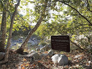
San Juan Hot Springs, also San Juan Capistrano Hot Springs, is a geothermal area in what is now Ronald W. Caspers Wilderness Park, near Cleveland National Forest, in Orange County, California in the United States. The springs were used by the Indigenous peoples of the region, and were an integral part of the dominion of Misíon San Juan Capistrano. They were later developed and used, on and off for a hundred years, as a resort area of post-settlement Southern California. The 52 springs were designated Orange County Historic Landmark No. 38 in 1989.

<span class="mw-page-title-main">Soboba Hot Springs</span> Geothermal site in California

Soboba Hot Springs are a historic hot springs and resort in Riverside County, California, United States. The springs issued from the side of a steep ravine "with narrow, precipitous sides, and the rock exposed is largely a crushed gneiss...the thermal character of the springs is due to crushing and slipping of the rocks". The Soboba Hot Springs resort was adjacent to the reservation of the Soboba Band of Luiseño Indians. Soboba means hot water in the Luiseño language.

<span class="mw-page-title-main">Urbita Hot Springs</span> Geothermal site in California

Urbita Hot Springs was a historic hot springs and amusement park in San Bernardino County, California, United States. Urbita Springs Park was located between E Street and Colton Street in San Bernardino where the Inland Center mall stands today.

References

  1. Berry, G.W.; Grim, P.J.; Ikelman, J.A. (1980). Thermal springs list for the United States (Report). Key to Geophysical Records Documentation No. 12. Environmental Data and Information Service National Geophysical and Solar-Terrestrial Data Center. Boulder, Colo.: U.S. Department of Commerce, National Oceanic and Atmospheric Administration (NOAA). p. 14. doi:10.2172/6737326.
  2. 1 2 Higgins, Chris T.; Therberge, Albert E. Jr.; Ikelman, Joy A. (1980). Geothermal Resources of California (PDF) (Map). NOAA National Geophysical Center. Sacramento: California Department of Mines and Geology.
  3. "Riverside County Scenes Varied". The Register. January 15, 1967. p. 110. Retrieved 2023-11-18.
  4. "City of Moreno Valley Cultural Resources Report" (PDF). July 2006. p. 5.10-9.
  5. 1 2 3 Lech, Steve (2005). Resorts of Riverside County. Arcadia Publishing. pp. 69–70. ISBN   978-0-7385-3078-9.
  6. 1 2 "New Owner Makes Plans to Promote Eden Hot Springs". Riverside Daily Press. August 26, 1926. p. 2. Retrieved 2023-11-18.
  7. "Asbestos and Cement Plant to be Built". The Perris Progress. February 21, 1924. p. 5. Retrieved 2023-11-18.
  8. "Quarter Mile Race Feature at Rodeo". Riverside Daily Press. March 26, 1946. p. 6. Retrieved 2023-11-18.
  9. 1 2 "The Bone Mine". The Banning Record. March 7, 1918. p. 2. Retrieved 2023-11-17.
  10. "James Glover: Man of many talents". Redlands Daily Facts. September 12, 2009. Retrieved 2023-11-17.
  11. "From Frank A. Armstrong". The Citrograph. July 30, 1904. p. 6. Retrieved 2023-11-17.
  12. 1 2 3 Waring, Gerald Ashley (January 1915). Springs of California. U.S. Department of the Interior, Geological Survey Water-Supply Papers. Washington, D.C.: U.S. Government Printing Office. p. 37. doi:10.3133/wsp338. Water Supply Paper No. 338 via HathiTrust.
  13. "Makes Improvements". The Los Angeles Times. January 26, 1910. p. 28. Retrieved 2023-11-18.
  14. "Death Claims James B. Glover; City Pays Tribute to His Memory". Redlands Daily Facts. March 25, 1921. p. 5. Retrieved 2023-11-18.
  15. "Frank A. Armstrong". The Banning Record. May 25, 1922. p. 3. Retrieved 2023-11-17.
  16. "In and Around the Courthouse". Riverside Daily Press. March 8, 1926. p. 12. Retrieved 2023-11-17.
  17. 1 2 "Interview of S. Charles Lee" (PDF). library.UCLA.edu. 1986. Retrieved 2023-11-17.
  18. 1 2 "Million Dollars Improvements for Eden Hot Springs". Lake Elsinore Valley Sun-Tribune. January 30, 1930. p. 10. Retrieved 2023-11-18.
  19. "Los Angeles Capitalist Buys Large Interest in Eden Springs". Riverside Daily Press. December 24, 1929. p. 4. Retrieved 2023-11-18.
  20. 1 2 3 "Fire levels historic resort in Hemet". The Valley Tribune. August 15, 1979. p. 10. Retrieved 2023-11-18.
  21. "Rancho Grande". The San Bernardino County Sun. April 18, 1946. p. 4. Retrieved 2023-11-18.
  22. "Quarter Mile Race Feature at Rodeo". Riverside Daily Press. March 26, 1946. p. 6. Retrieved 2023-11-18.
  23. 1 2 "Eden Springs Sold at Auction". Riverside Daily Press. May 10, 1952. p. 15. Retrieved 2023-11-17.
  24. "Golden Sells Store, Buys Hot Springs". Riverside Daily Press. June 26, 1952. p. 22. Retrieved 2023-11-18.
  25. "This Is Canadian Springs". Desert Dispatch. September 11, 1958. p. 3. Retrieved 2023-11-18.
  26. "Brush fires blacken more than 6,000 acres". The San Bernardino County Sun. September 23, 1975. p. 1. Retrieved 2023-11-18.
  27. Albright, L. Barry; Kendall, Jr., Arthur (August 3, 2000). Biostratigraphy and Vertebrate Paleontology of the San Timoteo Badlands, Southern California. University of California Press. doi:10.1525/california/9780520098367.003.0001. ISBN   978-0-520-09836-7.
  28. "Big Pine Citizen 2 March 1918 — California Digital Newspaper Collection". cdnc.ucr.edu. Retrieved 2023-11-17.
  29. Waring, Gerald A. (1919). "Hot Springs". Ground water in the San Jacinto and Temecula basins, California. U.S. Department of the Interior, Geological Survey Water-Supply Papers. U.S. Government Printing Office. pp. 24–26. doi:10.3133/wsp429. Water Supply Paper No. 429. Retrieved 2023-11-14 via HathiTrust.