Related Research Articles

Beckenham is a town in Greater London, England, within the London Borough of Bromley and the historic county of Kent. It is located 8.4 miles (13.5 km) south-east of Charing Cross, situated north of Elmers End and Eden Park, east of Penge, south of Lower Sydenham and Bellingham, and west of Bromley and Shortlands. Its population at the 2011 census counted 46,844 inhabitants.

Chislehurst is a suburban district of south-east London, England, in the London Borough of Bromley. It lies east of Bromley, south-west of Sidcup and north-west of Orpington, 10 miles (16 km) south-east of Charing Cross. Before the creation of Greater London in 1965, it was in Kent.

Orpington is a town and area in south east London, England, within the London Borough of Bromley. It is 13.4 miles south east of Charing Cross.
The London Borough of Bromley is the southeasternmost of the London boroughs that make up Greater London, bordering the ceremonial county of Kent, which most of Bromley was part of before 1965. The borough's population is an estimated 332,336. It is named after Bromley, its principal town; other major towns are Penge, Hayes, West Wickham, Chislehurst, Beckenham and Orpington. The local authority is Bromley London Borough Council.

Newstead Wood School is a selective girls' grammar school in Avebury Road, Orpington, south east London, England.

Hurst is a village in the civil parish of St Nicholas Hurst in the English county of Berkshire.

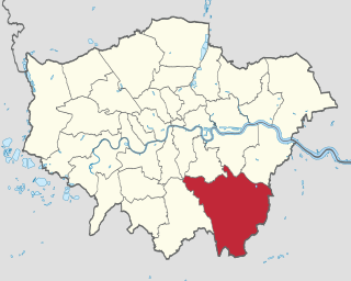
Orpington is a constituency created in 1945 and represented in the House of Commons of the UK Parliament since 2019 by Gareth Bacon, a Conservative. It is the largest constituency in Greater London by area, covering the east and south of the London Borough of Bromley.

St Mary Cray is an area of South East London, England, within the London Borough of Bromley. Historically it was a market town in the county of Kent. It is located north of Orpington, and 13 miles (21 km) south-east of Charing Cross.

The A232 is a road running west–east across South London, which connects the A24 in Ewell with the A224 Orpington bypass.

Cray Wanderers Football Club is an English semi-professional football club based in Sidcup, London. Based on later reports, the club has a claim to have been established some time in 1860 in the twin villages of St Mary Cray and St Paul's Cray, near Orpington. Such a date would make it one of the oldest football clubs in the world.
St Paul's Cray is an area of South East London, England, within the London Borough of Bromley and the historic county of Kent. It is located south of Sidcup and north of Orpington.
Ruxley is a small settlement in southeast London, England, with no present formal boundaries. It is located 21 km (13 mi) southeast by east of Charing Cross, in the northeast corner of the London Borough of Bromley on the borough boundary with the southeast corner of the London Borough of Bexley, and is also adjacent to the Greater London border with Kent, overlapping into the Sevenoaks District and Borough of Dartford in Kent. Ruxley lies east of Sidcup and west of Swanley, on green belt land, where two main roads pass through east-west connecting London to the coast. Ruxley was a parish prior to 1557 and had its own thirteenth century church, St Botolph's. Ruxley's central location on the main road made it an important meeting place for the Hundred of Ruxley, which was named after it. Today still a major transport route, Ruxley's location on green belt land is on the edge of London's urban sprawl, industrial and residential areas are found on the west side, but to the east this quickly turns into more rural woodland and farmland. Ruxley Gravel Pits is a biological Site of Special Scientific Interest located on the west side of Ruxley. Today the area is known for Ruxley Manor, a large site with a garden centre and other retailers and services.
Darrick Wood School is a mixed secondary school in Orpington, London Borough of Bromley, United Kingdom with a current roll of 1785 pupils. It was first opened in 1975.
This page provides brief details of primary schools in the borough of Three Rivers in Hertfordshire, England, United Kingdom.

Crofton is a suburb of Orpington in southeast London, England, located in the London Borough of Bromley and the historic county of Kent. It is about 13.6 miles (21.9 km) southeast of Charing Cross. It lies south of Petts Wood, west of Orpington and Broom Hill, north of Green Street Green and Farnborough, north-east of Locksbottom and east of Bromley Common.
References
- ↑ Greater London Authority, is in The London Plan: The Sub Regions Archived 2008-02-27 at the Wayback Machine
- ↑ "Hillside Primary School Online". Archived from the original on 2002-08-02.
- ↑ "Charterhouse Pre-School".
- ↑ "Cannock House Day Nursery". Archived from the original on 2008-01-05. Retrieved 2008-02-23.
- ↑ "Asquith Day Nurseries". Archived from the original on 2006-10-22.
- ↑ "Warren Road Primary School – Excellence For All".
- ↑ "Hillside Primary School Online". Archived from the original on 2002-08-02.
- ↑ "The Highway Primary School - Home".
- ↑ http://www.darrickwood-inf.bromley.sch.uk Archived 2008-03-09 at the Wayback Machine
- ↑ "Home | Perry Hall Primary School".
- ↑ "Crofton Schools Academy Trust". Archived from the original on 2016-04-22. Retrieved 2019-08-03.
- ↑ http://www.tubbenden-jun.bromley.sch.uk Archived 2008-02-02 at the Wayback Machine