
America's first transcontinental railroad was a 1,911-mile (3,075 km) continuous railroad line built between 1863 and 1869 that connected the existing eastern U.S. rail network at Council Bluffs, Iowa, with the Pacific coast at the Oakland Long Wharf on San Francisco Bay. The rail line was built by three private companies over public lands provided by extensive U.S. land grants. Building was financed by both state and U.S. government subsidy bonds as well as by company-issued mortgage bonds. The Western Pacific Railroad Company built 132 miles (212 km) of track from the road's western terminus at Alameda/Oakland to Sacramento, California. The Central Pacific Railroad Company of California (CPRR) constructed 690 miles (1,110 km) east from Sacramento to Promontory Summit, Utah Territory. The Union Pacific Railroad (UPRR) built 1,085 miles (1,746 km) from the road's eastern terminus at the Missouri River settlements of Council Bluffs and Omaha, Nebraska, westward to Promontory Summit.

John Wesley Powell was an American geologist, U.S. Army soldier, explorer of the American West, professor at Illinois Wesleyan University, and director of major scientific and cultural institutions. He is famous for his 1869 geographic expedition, a three-month river trip down the Green and Colorado rivers, including the first official U.S. government-sponsored passage through the Grand Canyon.
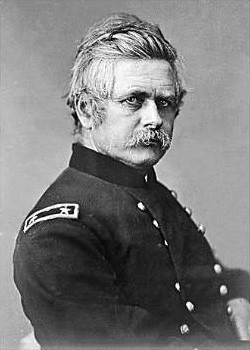
Edward Otho Cresap Ord, frequently referred to as E. O. C. Ord, was an American engineer and United States Army officer who saw action in the Seminole War, the Indian Wars, and the American Civil War. He commanded an army during the final days of the Civil War, and was instrumental in forcing the surrender of Confederate General Robert E. Lee. He also designed Fort Sam Houston. He died in Havana, Cuba of yellow fever.
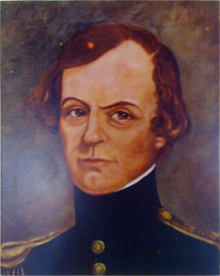
John Williams Gunnison was an American military officer and explorer.

Rear Admiral Benjamin Franklin Sands was an officer in the United States Navy during the Mexican–American War and the American Civil War.
The Pacific Railroad Surveys (1853–1855) were a series of explorations of the American West designed to find and document possible routes for a transcontinental railroad across North America. The expeditions included surveyors, scientists, and artists and resulted in an immense body of data covering at least 400,000 square miles (1,000,000 km2) on the American West. "These volumes... constitute probably the most important single contemporary source of knowledge on Western geography and history and their value is greatly enhanced by the inclusion of many beautiful plates in color of scenery, native inhabitants, fauna and flora of the Western country." Published by the United States War Department from 1855 to 1860, the surveys contained significant material on natural history, including many illustrations of reptiles, amphibians, birds, and mammals. In addition to describing the route, these surveys also reported on the geology, zoology, botany, paleontology, climatology of the land as well as provided ethnographic descriptions of the Native peoples encountered during the surveys. Importantly, a map of routes for a Pacific railroad, was compiled to accompany the report.

Aaron Harrison Cragin was an American politician and a United States Representative and Senator from New Hampshire.
George Karl Ludwig Preuss (1803–1854), anglicized as Charles Preuss, was a surveyor and cartographer who accompanied John C. Fremont on three of his five exploratory expeditions of the American west, including the expedition where he and Fremont were the first to record seeing Lake Tahoe from a mountaintop vantage point as they traversed what is now Carson Pass in February 1844. Preuss drew two important maps based on his records from Fremont's first two expeditions.
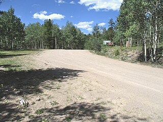
Cochetopa Pass is a mountain pass in the Rocky Mountains of south-central Colorado. It lies on the Continental Divide between the city of Gunnison to the northwest and the town of Saguache to the southeast. It also lies on the boundary between the Gunnison and Rio Grande National Forests. Its name is taken from the Cochetopa Hills that it lies within, Cochetopa being the Ute Indian word for "pass of the buffalo". The original pass is traversed by Saguache County Road NN14, a maintained gravel road. Another crossing, sometimes called North Cochetopa Pass and more often simply North Pass, is located nearby on State Highway 114, which is paved and reaches a slightly higher elevation.
The U.S. Army Corps of Topographical Engineers was a branch of the United States Army authorized on 4 July 1838. It consisted only of officers who were handpicked from West Point and was used for mapping and the design and construction of federal civil works such as lighthouses and other coastal fortifications and navigational routes. Members included such officers as George Meade, John C. Frémont, Thomas J. Cram and Stephen Long. It was merged with the United States Army Corps of Engineers on 31 March 1863, at which point the Corps of Engineers also assumed the Lakes Survey for the Great Lakes. In the mid-19th century, Corps of Engineers' officers ran Lighthouse Districts in tandem with U.S. Naval officers.
Edward Meyer Kern was an American artist, topographer, and explorer of California, the Southwestern United States, and East Asia. He is the namesake of the Kern River and Kern County, California.
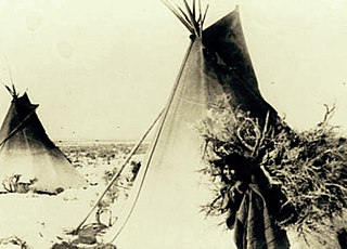
The Pahvant or Pahvants were a band of Ute people that lived in present-day Utah. Called the "Water People", they fished and hunted waterfowl. They were also farmers and hunter-gatherers. In the 18th century they were known to be friendly and attentive, but after a chief's father was killed by emigrating white settlers, a group of Pahvant Utes killed John Williams Gunnison and seven of his men during his exploration of the area. The bodies of water of their homeland were dried up after Mormons had diverted the water for irrigation. Having intermarried with the Paiutes, they were absorbed into the Paiute Indian Tribe of Utah and relocated to reservations.
Howard Stansbury was a major in the U.S. Army Corps of Topographical Engineers. One of his most notable achievements was leading a two-year expedition (1849–1851) to survey the Great Salt Lake and its surroundings. The expedition report entitled Exploration and survey of the valley of the Great Salt Lake of Utah, including a reconnaissance of a new route through the Rocky Mountains was published in 1852 providing the first serious scientific exploration of the flora and fauna of the Great Salt Lake Valley as well as a favorable impression of the members of the Church of Jesus Christ of Latter-day Saints, who had settled there beginning in 1847.

Frederick Wilhelm von Egloffstein was a German-born military man, explorer, mapmaker, landscape artist and engraver. He was the first person to employ ruled glass screens, together with photography, to produce engravings.
The 1854 Beckwith Expedition by Lieutenant Edward Griffin Beckwith surveyed an area that was subsequently used for the Western Pacific's 1910 Feather River Route.

Oasis is a census-designated place in northeastern Millard County, Utah, United States. The population was 75 at the 2010 census. Once the main rail shipping point in Millard County, Oasis declined in importance after the establishment of Delta, now the county's largest city.

This is a bibliography of the U.S. State of Colorado.

Almon Harris Thompson, also known as A. H. Thompson, was an American topographer, geologist, explorer, educator and Civil War veteran. Often called "The Professor" or simply "Prof", Thompson is perhaps best known for being second in command of John Wesley Powell's Second Geographical Expedition (1871–1875), a federally funded scientific expedition that retraced the route of Powell's original expedition in order to further explore and map the drainages and canyons of the Green and Colorado Rivers in what is now southern Utah and northern Arizona. Thompson's diary of the expedition was originally published in the Utah Historical Quarterly in 1939. Through his work on the Powell expeditions and later as a geographer at the U.S. Geological Survey, he was responsible for naming many geographic locations in the Western United States. Thompson is also known for being a founding member of the National Geographic Society.
Beekman Du Barry, Sr. was a brigadier general in the United States Army. He briefly participated in the Northern Pacific Railroad Survey of 1853 to 1854, and served with distinction in the Commissary of Subsistence of the Union Army during the American Civil War.
