Eethen

Last updated
Eethen
Village
Hervormde kerk Eethen.jpg
Dutch Reformed church Eethen
Eethen wapen 1936.svg
2010-NL-P10-Noord-Brabant-positiekaart-gemnamen.jpg
Red pog.svg
Eethen
Location in the province of North Brabant in the Netherlands
Netherlands location map.svg
Red pog.svg
Eethen
Eethen (Netherlands)
Coordinates: 51°43′51″N5°3′10″E / 51.73083°N 5.05278°E / 51.73083; 5.05278
Country Netherlands
Province North Brabant
Municipality Altena
Area
[1]
  Total5.86 km2 (2.26 sq mi)
Elevation
[2]
1.4 m (4.6 ft)
Population
 (2021) [1]
  Total890
  Density150/km2 (390/sq mi)
Time zone UTC+1 (CET)
  Summer (DST) UTC+2 (CEST)
Postal code
4266 [1]
Dialing code 0416

Eethen is a village in the Dutch province of North Brabant. It is located in the municipality of Altena.

The village was first mentioned in 850 as Atina. The etymology is unclear. [3] Eethen developed on a sand hill in the Middle Ages and part of the original ring road is still visible. [4]

The Dutch Reformed church dates from the 12th century. The tower was added in the late-14th century. In 1944, it was severely damaged by World War II and was restored and reconstructed between 1948 and 1951. [4]

Eethen was home to 310 people 1840. [5] Eethen was a separate municipality between 1923 and 1973. It was formed by the merging of the municipalities of Drongelen, Genderen, and Meeuwen, and became a part of Aalburg in 1973. [6]

Related Research Articles

<span class="mw-page-title-main">Aalburg</span> Former municipality in North Brabant, Netherlands

Aalburg is a former municipality in the southern Netherlands, in the province of North Brabant. The municipality had been formed in 1973 by the merging of the former municipalities of Eethen, Veen, and Wijk en Aalburg. On January 1, 2019 it joined Werkendam and Woudrichem in the new municipality of Altena.

<span class="mw-page-title-main">Municipalities of the Netherlands</span> Second-level administrative divisions in the Netherlands

As of 1 January 2023, there are 342 municipalities and three special municipalities in the Netherlands. The latter is the status of three of the six island territories that make up the Dutch Caribbean. Municipalities are the second-level administrative division, or public bodies, in the Netherlands and are subdivisions of their respective provinces. Their duties are delegated to them by the central government and they are ruled by a municipal council that is elected every four years. Municipal mergers have reduced the total number of municipalities by two-thirds since the first official boundaries were created in the mid 19th century. Municipalities themselves are informally subdivided into districts and neighbourhoods for administrative and statistical purposes.

<span class="mw-page-title-main">Bad Nieuweschans</span> Village in Groningen, Netherlands

Bad Nieuweschans is a village in the north-eastern Netherlands on the border with Germany. It forms part of the municipality of Oldambt. Nieuweschans means "new fortification (sconce)". In 2009, the word Bad ("spa") was prefixed to the name of the village to promote it as a tourist destination.

<span class="mw-page-title-main">Koewacht</span> Village

Koewacht is a village on the border between the Netherlands and Belgium.

<span class="mw-page-title-main">Heeswijk</span> Village in North Brabant, Netherlands

Heeswijk is a Dutch village. It is located in the province of North Brabant, in the south of the Netherlands.

<span class="mw-page-title-main">Vries, Netherlands</span> Village in Drenthe, Netherlands

Vries is a village in the Dutch province of Drenthe. It is a part of the municipality of Tynaarlo, and lies about 8 km north of Assen.

<span class="mw-page-title-main">Leerbroek</span> Village in Utrecht, Netherlands

Leerbroek is a village in the Dutch province of Utrecht. It is a part of the municipality of Vijfheerenlanden, and lies about 9 km (6 mi) northeast of Gorinchem.

<span class="mw-page-title-main">Lexmond</span> Village in Utrecht, Netherlands

Lexmond is a village in the Dutch province of Utrecht. It is a part of the municipality of Vijfheerenlanden, and lies about 7 km south of IJsselstein.

<span class="mw-page-title-main">Almkerk</span> Village in North Brabant, Netherlands

Almkerk is a village in the municipality of Altena, Netherlands. It is located about 7 km south of Gorinchem.

<span class="mw-page-title-main">Amstenrade</span> Village in Limburg, Netherlands

Amstenrade is a village in the municipality of Beekdaelen, in the Netherlands. It is located about 7 km northwest of Heerlen. The Amstenrade Castle is located in the village.

<span class="mw-page-title-main">Bath, Netherlands</span> Village in Zeeland, Netherlands

Bath is a small village and a former municipality in the Dutch province of Zeeland, lying on the north shore of the Western Scheldt. It is now located in the municipality of Reimerswaal, about 10 km southwest of Bergen op Zoom.

<span class="mw-page-title-main">Groede</span> Village in Zeeland, Netherlands

Groede is a village in the Dutch province of Zeeland. It is located about 5 km north of Oostburg in the municipality of Sluis.

<span class="mw-page-title-main">Geulle</span> Village in Limburg, Netherlands

Geulle is a village in the Dutch province of Limburg. It is located in the municipality of Meerssen, about 8 km southwest of Geleen.

<span class="mw-page-title-main">Herten, Netherlands</span> Village in Limburg, Netherlands

Herten is a village in the southeastern Netherlands. It is located in the municipality of Roermond, Limburg.

<span class="mw-page-title-main">Genderen</span> Village in North Brabant, Netherlands

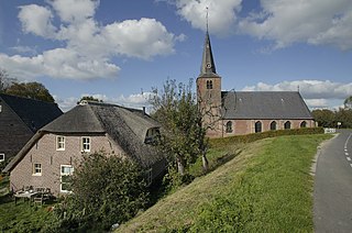
Genderen is a village in the Dutch province of North Brabant. It is located in the municipality of Altena.

<span class="mw-page-title-main">Giessen, Netherlands</span> Village in North Brabant, Netherlands

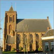
Giessen is a village in the Dutch province of North Brabant. It is located in the municipality of Altena, about 7 km southeast of Gorinchem.

<span class="mw-page-title-main">Made, Netherlands</span> Village in North Brabant, Netherlands

Made is a town in the Dutch province of North Brabant. It is located in the municipality of Drimmelen, about 10 km northeast of Breda.
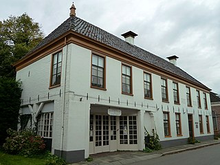
<span class="mw-page-title-main">Rijswijk, North Brabant</span> Village in North Brabant, Netherlands

Rijswijk is a village in the Dutch province of North Brabant. It is located in the municipality of Altena, about 5 km southeast of Gorinchem.

<span class="mw-page-title-main">Tjerkwerd</span> Village in Friesland, Netherlands

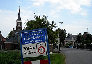
Tjerkwerd is a village in Súdwest-Fryslân municipality in the province Friesland of the Netherlands. It had a population of 455 in January 2017.

<span class="mw-page-title-main">Noordhorn</span> Village in Groningen, Netherlands

Noordhorn is a village in the Dutch province of Groningen. It is part of the municipality of Westerkwartier and is separated from Zuidhorn by the van Starkenborghkanaal.

References

  1. 1 2 3 "Kerncijfers wijken en buurten 2021". Central Bureau of Statistics. Retrieved 14 April 2022.
  2. "Postcodetool for 4266EA". Actueel Hoogtebestand Nederland (in Dutch). Het Waterschapshuis. Retrieved 14 April 2022.
  3. "Eethen - (geografische naam)". Etymologiebank (in Dutch). Retrieved 14 April 2022.
  4. 1 2 Chris Kolman & Ronald Stenvert (1997). Eethen (in Dutch). Zwolle: Waanders. ISBN   90 400 9945 6 . Retrieved 14 April 2022.
  5. "Eethen". Plaatsengids (in Dutch). Retrieved 14 April 2022.
  6. van der Meer, Ad; Boonstra, Onno (2006). Repertorium van Nederlandse gemeenten 1812–2006 (PDF) (in Dutch). The Hague: Data Archiving and Networked Services (DANS) - Royal Netherlands Academy of Arts and Sciences. ISBN   90-6984-495-8. OCLC   206151799. Archived from the original (PDF) on 2010-12-26.