A solstice is the time when the Sun reaches its most northerly or southerly excursion relative to the celestial equator on the celestial sphere. Two solstices occur annually, around 20–22 June and 20–22 December. In many countries, the seasons of the year are defined by reference to the solstices and the equinoxes.

Orbital inclination measures the tilt of an object's orbit around a celestial body. It is expressed as the angle between a reference plane and the orbital plane or axis of direction of the orbiting object.

The Tropic of Cancer, also known as the Northern Tropic, is the Earth's northernmost circle of latitude where the Sun can be seen directly overhead. This occurs on the June solstice, when the Northern Hemisphere is tilted toward the Sun to its maximum extent. It also reaches 90 degrees below the horizon at solar midnight on the December Solstice. Using a continuously updated formula, the circle is currently 23°26′09.7″ (or 23.43603°) north of the Equator.

In astronomy, an analemma is a diagram showing the position of the Sun in the sky as seen from a fixed location on Earth at the same mean solar time over the course of a year. The change of position is a result of the shifting of the angle in the sky of the path that the Sun takes in respect to the stars. The diagram resembles a figure eight. Globes of the Earth often display an analemma as a two-dimensional figure of equation of time vs. declination of the Sun.

A terminator or twilight zone is a moving line that divides the daylit side and the dark night side of a planetary body. The terminator is defined as the locus of points on a planet or moon where the line through the center of its parent star is tangent. An observer on the terminator of such an orbiting body with an atmosphere would experience twilight due to light scattering by particles in the gaseous layer.

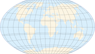
A circle of latitude or line of latitude on Earth is an abstract east–west small circle connecting all locations around Earth at a given latitude coordinate line.

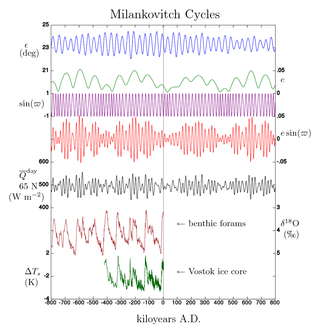
Milankovitch cycles describe the collective effects of changes in the Earth's movements on its climate over thousands of years. The term was coined and named after the Serbian geophysicist and astronomer Milutin Milanković. In the 1920s, he provided a more definitive and quantitative analysis than James Croll's earlier hypothesis that variations in eccentricity, axial tilt, and precession combined to result in cyclical variations in the intra-annual and latitudinal distribution of solar radiation at the Earth's surface, and that this orbital forcing strongly influenced the Earth's climatic patterns.

The polar regions, also called the frigid zones or polar zones, of Earth are Earth's polar ice caps, the regions of the planet that surround its geographical poles, lying within the polar circles. These high latitudes are dominated by floating sea ice covering much of the Arctic Ocean in the north, and by the Antarctic ice sheet on the continent of Antarctica and the Southern Ocean in the south.
Seasonal lag is the phenomenon whereby the date of maximum average air temperature at a geographical location on a planet is delayed until some time after the date of maximum daylight. This also applies to the minimum temperature being delayed until some time after the date of minimum insolation. Cultural seasons are often aligned with annual temperature cycles, especially in the agrarian context. Peak agricultural growth often depends on both insolation levels and soil/air temperature. Rainfall patterns are also tied to temperature cycles, with warmer air able to hold more water vapor than cold air.

Solar irradiance is the power per unit area received from the Sun in the form of electromagnetic radiation in the wavelength range of the measuring instrument. Solar irradiance is measured in watts per square metre (W/m2) in SI units.

Many astronomical phenomena viewed from the planet Mars are the same as or similar to those seen from Earth; but some are quite different. For example, because the atmosphere of Mars does not contain an ozone layer, it is also possible to make UV observations from the surface of Mars.

A lunar standstill or lunistice is when the Moon reaches its furthest north or furthest south point during the course of a month. The declination at lunar standstill varies in a cycle 18.6 years long between 18.134° and 28.725°, due to lunar precession. These extremes are called the minor and major lunar standstills.

The five main latitude regions of Earth's surface comprise geographical zones, divided by the major circles of latitude. The differences between them relate to climate. They are as follows:
- The North Frigid Zone, between the North Pole at 90° N and the Arctic Circle at 66°33′50.3″ N, covers 4.12% of Earth's surface.
- The North Temperate Zone, between the Arctic Circle at 66°33′50.3″ N and the Tropic of Cancer at 23°26′09.7″ N, covers 25.99% of Earth's surface.
- The Torrid Zone, between the Tropic of Cancer at 23°26′09.7″ N and the Tropic of Capricorn at 23°26′09.7″ S, covers 39.78% of Earth's surface.
- The South Temperate Zone, between the Tropic of Capricorn at 23°26′09.7″ S and the Antarctic Circle at 66°33′50.3″ S, covers 25.99% of Earth's surface.
- The South Frigid Zone, from the Antarctic Circle at 66°33′50.3″ S and the South Pole at 90° S, covers 4.12% of Earth's surface.

Daytime or day as observed on Earth is the period of the day during which a given location experiences natural illumination from direct sunlight. Daytime occurs when the Sun appears above the local horizon, that is, anywhere on the globe's hemisphere facing the Sun. In direct sunlight the movement of the sun can be recorded and observed using a sundial that casts a shadow that slowly moves during the day. Other planets and natural satellites that rotate relative to a luminous primary body, such as a local star, also experience daytime, but this article primarily discusses daytime on Earth.

Sun path, sometimes also called day arc, refers to the daily and seasonal arc-like path that the Sun appears to follow across the sky as the Earth rotates and orbits the Sun. The Sun's path affects the length of daytime experienced and amount of daylight received along a certain latitude during a given season.

The equator is the circle of latitude that divides Earth into the Northern and Southern hemispheres. It is an imaginary line located at 0 degrees latitude, about 40,075 km (24,901 mi) in circumference, halfway between the North and South poles. The term can also be used for any other celestial body that is roughly spherical.
A season is a division of the year based on changes in weather, ecology, and the number of daylight hours in a given region. On Earth, seasons are the result of the axial parallelism of Earth's tilted orbit around the Sun. In temperate and polar regions, the seasons are marked by changes in the intensity of sunlight that reaches the Earth's surface, variations of which may cause animals to undergo hibernation or to migrate, and plants to be dormant. Various cultures define the number and nature of seasons based on regional variations, and as such there are a number of both modern and historical definitions of the seasons.
North African climate cycles have a unique history that can be traced back millions of years. The cyclic climate pattern of the Sahara is characterized by significant shifts in the strength of the North African Monsoon. When the North African Monsoon is at its strongest, annual precipitation and consequently vegetation in the Sahara region increase, resulting in conditions commonly referred to as the "green Sahara". For a relatively weak North African Monsoon, the opposite is true, with decreased annual precipitation and less vegetation resulting in a phase of the Sahara climate cycle known as the "desert Sahara".

The position of the Sun in the sky is a function of both the time and the geographic location of observation on Earth's surface. As Earth orbits the Sun over the course of a year, the Sun appears to move with respect to the fixed stars on the celestial sphere, along a circular path called the ecliptic.

The climate of Pluto concerns the atmospheric dynamics, weather, and long-term trends on the dwarf planet Pluto. Five climate zones are assigned on the dwarf planet: tropics, arctic, tropical arctic, diurnal, and polar. These climate zones are delineated based on astronomically defined boundaries or sub-solar latitudes, which are not associated with the atmospheric circulations on the dwarf planet. Charon, the largest moon of Pluto, is tidally locked with it, and thus has the same climate zone structure as Pluto itself.


