
Bedford Township is a township in Bedford County, Pennsylvania, United States. The population was 5,395 at the 2010 census.

Snake Spring Township is a township in Bedford County, Pennsylvania, United States. The population was 1,639 at the 2010 census.
Maryland Route 213 is a 68.25-mile (109.84 km) state highway located on the Eastern Shore of Maryland in the United States. The route runs from MD 662 in Wye Mills, Queen Anne's County north to the Pennsylvania border in Cecil County, where it continues into that state as Pennsylvania Route 841. The route, which is a two-lane undivided highway its entire length, passes through mostly rural areas as well as the communities of Centreville, Chestertown, Galena, Cecilton, Chesapeake City, and Elkton. MD 213 intersects many routes including U.S. Route 50 near Wye Mills, US 301 near Centreville, and US 40 in Elkton. It crosses over the Chesapeake & Delaware Canal in Chesapeake City on the Chesapeake City Bridge. MD 213 is designated by the state as the Chesapeake Country Scenic Byway between the southern terminus and Chesapeake City with the portion north of MD 18 in Centreville a National Scenic Byway. In addition, the route is also considered part of the Atlantic to Appalachians Scenic Byway between Chesapeake City and MD 273 in Fair Hill.
Mill Creek is a 14.5-mile-long (23.3 km) tributary of Opequon Creek, belonging to the Potomac River and Chesapeake Bay watersheds, located in Berkeley County in West Virginia's Eastern Panhandle. Its name reflects its past as a popular site for various types of mills, beginning with one constructed by Morgan Morgan in the mid-18th century near his cabin in present-day Bunker Hill.
Bermudian Creek is a 24.9-mile-long (40.1 km) tributary of Conewago Creek in Adams and York counties in Pennsylvania in the United States.
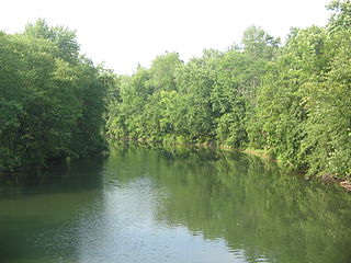
Spring Creek is a 25.2-mile-long (40.6 km) tributary of Bald Eagle Creek in Centre County, Pennsylvania in the United States.
The LeTort Spring Run is a 9.4-mile-long (15.1 km) tributary of Conodoguinet Creek in Cumberland County, Pennsylvania in the United States.

Penns Valley is an eroded anticlinal valley of the Pennsylvania ridge and valley geologic region of the Appalachian Mountain range. The valley is located in southern Centre County, Pennsylvania. Along with the Nittany Valley to the north and east, it is part of the larger Nittany Anticlinorium. It is bordered by Nittany Mountain to the north, the Seven Mountains range to the south, and connects to the larger Nittany Valley to the west. There are two smaller subordinate valleys typically associated with the greater valley; Georges Valley in the south, separated by Egg Hill, and Brush Valley in the north, separated by Brush Mountain.
Bald Eagle Creek is a 55.2-mile-long (88.8 km) tributary of the West Branch Susquehanna River mostly in Centre County, Pennsylvania, in the United States.

The Geology of Pennsylvania consists of six distinct physiographic provinces, three of which are subdivided into different sections. Each province has its own economic advantages and geologic hazards and plays an important role in shaping everyday life in the state. They are: the Atlantic Coastal Plain Province, the Piedmont Province, the New England Province, the Ridge and Valley Province, the Appalachian Plateau Province, and the Central Lowlands Province.

The Silurian Tuscarora Formation — also known as Tuscarora Sandstone or Tuscarora Quartzite — is a mapped bedrock unit in Pennsylvania, Maryland, West Virginia, and Virginia, USA.
Honey Creek is a 20.3-mile-long (32.7 km) tributary of Kishacoquillas Creek in Mifflin County, Pennsylvania in the United States.

Wills Creek Formation is a mapped Silurian bedrock unit in Pennsylvania, Maryland, Virginia, and West Virginia.
Stone Mountain is a stratigraphic ridge in central Pennsylvania, United States, trending northwest of the Jacks Mountain ridge and Jacks Mountain Anticline. The ridge line separates Kishacoquillas Valley from the Seven Mountains area. Stone Mountain lies in, and the ridge line forms part of the border between, Mifflin and Huntingdon counties.

Chestnut Ridge is an elongate hill trending northeast-southwest in west-central Bedford County, Pennsylvania. It is partially forested with rural homes, farms, and notably apple orchards. Four small towns surround it: Schellsburg, New Paris, Fishertown, and Pleasantville. Shawnee State Park and Shawnee Lake lie immediately to the south of the ridge.

The Narrows is a water gap where the Raystown Branch of the Juniata River passes through Evitts Mountain in Bedford County, Pennsylvania. Both U.S. Route 30 and the Pennsylvania Turnpike pass through the gap. It is located in the townships of Snake Spring and Bedford.

Idaville is a census-designated place in Huntington Township, Adams County, Pennsylvania, United States. As of the 2010 census its population was 177. Idaville is served by the Bermudian Springs School District.
Bosley Minn is one of two names – the other being Wincle Minn – given to a prominent hill in southeast Cheshire and in the southwestern corner of the Peak District National Park in northern England. The long axis of the Minn runs NNE–SSW and its broad summit, which reaches to 386 metres (1,266 ft) at its highest point, slopes away to the valley of the Shell Brook in the east and towards Bosley Reservoir in the west. It is the western aspect of the hill, facing Bosley which is known as Bosley Minn whilst the eastern side which faces the village of Wincle is referred to as Wincle Minn.
Hensingersville, also known as New Hensingersville, is an unincorporated community located mostly in southwestern Lower Macungie Township, Lehigh County but also in Longswamp Township, Berks County, Pennsylvania, near the intersections of Pennsylvania Route 2018, Pennsylvania Route 3001, Chestnut Road, and Reservoir Hill Road. It is located in the Lehigh Valley, just south of the Borough of Alburtis and Lock Ridge, at the confluence of the west and east branches of Swabia Creek. Its elevation is 489 feet. Hensingersville appears on the East Greenville U.S. Geological Survey Map and is designated by the USGS as a Populated Place. It is split between the Alburtis zip code of 18011 and the Macungie zip code of 18062.


