The Thuringian Forest, is a mountain range in the southern parts of the German state of Thuringia, running northwest to southeast between the valley of the river Werra near Eisenach and the Thuringian-Vogtlandian Slate Mountains. The geographical boundary with the latter range follows approximately a line from Gehren via Großbreitenbach to Schönbrunn near Schleusingen, defined by the rivers Schleuse and Neubrunn on the southwestern slope, and Talwasser, Wohlrose and Möhre on the northeastern slope.

The Rhön Mountains are a group of low mountains in central Germany, located around the border area where the states of Hesse, Bavaria and Thuringia come together. These mountains, which are at the extreme southeast end of the East Hesse Highlands, are partly a result of ancient volcanic activity. They are separated from the Vogelsberg Mountains by the river Fulda and its valley. The highest mountain in the Rhön is the Wasserkuppe which is in Hesse. The Rhön Mountains are a popular tourist destination and walking area.

The Großer Feldberg is, at a height of 879.5 metres, the highest elevation of the Taunus mountains, and of the entire Rhenish Massif. It is situated in the Hochtaunuskreis district in Hessen, Germany.

Brace Mountain is the peak of a ridge in the southern Taconic Mountains, near the tripoint of the U.S. states of New York, Connecticut and Massachusetts. Its 2,311-foot (704 m) main summit is located in New York; it is the highest point in that state's Dutchess County.

The Wolfsklippen, also called the Wolfsklippe, is a granite mountain in the Harz mountains in Central Germany with an observation platform on the summit. Its height is frequently given as about 723 m above sea level (NN), but occasionally also as only around 710 m above NN.

The Blauberge or Blauberg are a mountain range in the Bavarian Prealps on the border between the states of Bavaria in Germany and Tyrol in Austria. Its highest summit is the Halserspitze, or Halserspitz at 1,862 m.

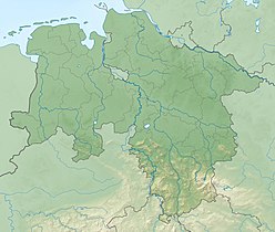
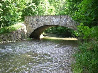
Kleine Steinau is a river of Lower Saxony, Germany. It is a 9.1 km (5.7 mi) long tributary of the Sieber, north of Herzberg am Harz in the district of Göttingen.

The Braakberg is a 645.5 metre high mountain in the Harz in central Germany that lies in the unincorporated area of Harz in the district of Göttingen in the state of Lower Saxony.

Harz granite is found in the Harz Mountains of central Germany. It may be divided into five types, all of which were widely used as natural stone: Knaupsholz granite, Birkenkopf granite, Wurmberg granite, Königskopf granite and Ilsestein granite. The first three granites were widely used in North Germany, Belgium and the Netherlands and, later, also in East Germany. Knaupsholz granite was "for a long time one of the most important types of cut stone in the former GDR".

The Trudenstein is a rock formation and popular hiker's destination in the Harz Mountains of central Germany. It is located in the federal state of Saxony-Anhalt.

The Königstein is a 189 m high hill in the northern Harz Foreland in the German state of Saxony-Anhalt. It is also known as the Kamelfelsen due to its unusually shaped sandstone rock formation.

The Geißstein, sometimes also called the Gaisstein, is a mountain in the Kitzbühel Alps with a height of 2,366 m (AA) that straddles the border between the federal Austrian states of Tyrol and Salzburg

The Feldalphorn, also known as the Feldalpenhorn, is a 1,923 m (AA) high mountain in the Kitzbühel Alps in Tyrol, Austria.
The Bobritzsch is a river of Saxony, Germany. It is a right tributary of the Freiberger Mulde with a length of about 38 km (24 mi). Its Gewässerkennzahl is 5422.

The Rehberg is a prominent hill, 576.8 m above sea level (NHN), in the German state of Rhineland-Palatinate. After the Grand Wintersberg in French North Alsace, the Rehberg is the second highest hill in the Wasgau, the Franco-German region that forms the southern part of the Palatine Forest and runs from the valley of the River Queich to the Col de Saverne. The Rehberg is also the highest hill on German soil in the Wasgau. As part of the Palatine Forest-North Vosges Biosphere Reserve it has been placed under special protection measures.

The Mathisleweiher is a large bog lake, under 2 hectares in area, in the Black Forest in southern Germany. It lies in the High Black Forest between Feldberg in the west and the Titisee in the east on the territory of Hinterzarten at about 999 m above NN southwest of the village in the Eschengrundmoos Nature Reserve. The pond impounds the Zartenbach which flows through it from west-southwest to east-northeast. The stream rises on the eastern slopes of the Ramselehöhe at about 1,055 m above NN, picks up the Eschengrundmoosbach from the right from the protected bog and runs for less than a kilometre before entering the lake. A shorter stream runs from the north from the woods of the Stuckwald. It has a catchment of 1.0 km2

The Rockeskyller Kopf near Rockeskyll in the county of Vulkaneifel in the German state of Rhineland-Palatinate is a hill, 554.6 m above sea level (NHN), in the Eifel mountains. It is an extinct volcano complex from the Quaternary period, around 360,000 years old and is designated as a natural monument (ND-7233-420).

The Alarmstange, at 545.2 m above sea level (NHN), is the highest point in the Montabaur Heights, a hill ride on the southwestern edge of the Westerwald. It lies near Horressen in the county of Westerwaldkreis in the German state of Rhineland-Palatinate. Together with the Köppel and the Lippersberg, the Alarmstange forms the centre of the ridge, on which is the largest contiguous woodland area in the Westerwald.