Signy Island is a small subantarctic island in the South Orkney Islands of Antarctica. It was named by the Norwegian whaler Petter Sørlle (1884–1933) after his wife, Signy Therese.
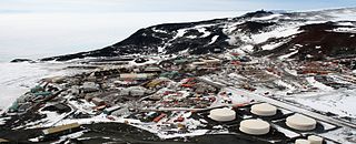
McMurdo Station is a United States Antarctic research station on the south tip of Ross Island, which is in the New Zealand-claimed Ross Dependency on the shore of McMurdo Sound in Antarctica. It is operated by the United States through the United States Antarctic Program (USAP), a branch of the National Science Foundation. The station is the largest community in Antarctica, capable of supporting up to 1,200 residents, and serves as one of three year-round United States Antarctic science facilities. All personnel and cargo going to or coming from Amundsen–Scott South Pole Station first pass through McMurdo. By road, McMurdo is 3 kilometres (1.9 mi) from New Zealand's smaller Scott Base.

Dundee Island is an ice-covered island lying east of the northeastern tip of Antarctic Peninsula and south of Joinville Island. It is named after the city of Dundee in Scotland.

Marguerite Bay or Margaret Bay is an extensive bay on the west side of the Antarctic Peninsula, which is bounded on the north by Adelaide Island and on the south by Wordie Ice Shelf, George VI Sound and Alexander Island. The mainland coast on the Antarctic Peninsula is Fallières Coast. Islands within the bay include Pourquoi Pas Island, Horseshoe Island, Terminal Island, and Lagotellerie Island. Marguerite Bay was discovered in 1909 by the French Antarctic Expedition under Jean-Baptiste Charcot, who named the bay for his wife.

Adelaide Island is a large, mainly ice-covered island, 139 kilometres (75 nmi) long and 37 kilometres (20 nmi) wide, lying at the north side of Marguerite Bay off the west coast of the Antarctic Peninsula. The Ginger Islands lie off the southern end. Mount Bodys is the easternmost mountain on Adelaide Island, rising to over 1,220 m. The island lies within the Argentine, British and Chilean Antarctic claims.
Arthur Harbour is a small harbour entered between Bonaparte Point and Amsler Island on the south-west coast of Anvers Island in the Palmer Archipelago of Antarctica.

Coronation Island is the largest of the South Orkney Islands, 25 nautical miles (46 km) long and from 3 to 8 nautical miles wide. The island extends in a general east–west direction, is mainly ice-covered and comprises numerous bays, glaciers and peaks, the highest rising to 1,265 metres (4,150 ft).
Surge Rocks are a group of five rocks, two always exposed, lying 190 metres (0.1 nmi) southwest of Eichorst Island and 1 kilometre (0.6 nmi) south-southeast of Bonaparte Point, Anvers Island. The name was suggested by Palmer Station personnel in 1972. Ocean swells working on the shoal surrounding these rocks, cause breaking and a "surge" of the water level in any weather condition.

Bransfield Strait or Fleet Sea is a body of water about 100 kilometres (60 mi) wide extending for 300 miles (500 km) in a general northeast – southwest direction between the South Shetland Islands and the Antarctic Peninsula.

Snow Hill Island is an almost completely snowcapped island, 33 km (21 mi) long and 12 km (7.5 mi) wide, lying off the east coast of the Antarctic Peninsula. It is separated from James Ross Island to the north-east by Admiralty Sound and from Seymour Island to the north by Picnic Passage. It is one of several islands around the peninsula known as Graham Land, which is closer to Argentina and South America than any other part of the Antarctic continent.

The Willis Islands are a small archipelago to the west of South Georgia Island in the South Georgia Islands. They are 2 miles (3.2 km) west of Bird Island, separated by the Stewart Strait. They were discovered on 14 January 1775 by Captain James Cook and named for Cook's midshipman Thomas Willis, the crew member who first sighted them. The Willis Islands were charted in greater detail and individually named by Discovery Investigations (DI) personnel between 1926-1930.
Amsler Island is a small island off the south coast of Anvers Island in the Palmer Archipelago of Antarctica. It sits between Loudwater Cove and Arthur Harbour.
The Duroch Islands are a group of islands and rocks which extend over an area of about 5 km2 (1.9 sq mi), centred about 1 km (0.62 mi) off Cape Legoupil on the north coast of Trinity Peninsula, Antarctica. They were discovered by a French expedition under Captain Jules Dumont d'Urville, 1837–40, who gave the name "Rocher Duroch" to one of the larger islands in the group after Ensign Joseph Duroch of d'Urville's expedition ship, the Astrolabe. The Falkland Islands Dependencies Survey, which charted the islands in 1946, recommended that the name Duroch be extended to include the entire group of islands. The islands are close to Chile's Bernardo O'Higgins Station at Cape Legoupil.
Wohlschlag Bay is a large bay indenting the western side of Ross Island, Antarctica, and lying between Harrison Bluff and Cape Royds. It was first charted by the Discovery Expedition under Robert Falcon Scott, 1901–1904, then named by the Advisory Committee on Antarctic Names (US-ACAN) in 1964 for Donald E. Wohlschlag, professor of biology at Stanford University, who outfitted the biology laboratories on the USNS Eltanin and at McMurdo Station.
The Flatvaer Islands, also known as the Ongul Islands, are a group of small islands lying at the east side of the entrance of Lützow-Holm Bay, 4 km from the coastline of Antarctica. They were mapped by Norwegian cartographers from air photos taken by the Lars Christensen Expedition (LCE), 1936–37. Many of the islands and their features were subsequently named by members of the Japanese Antarctic Research Expedition (JARE); unless otherwise noted, features noted in this article were named by JARE.
Paterson Islands is a group of small islands lying 7.4 kilometres (4 nmi) northeast of Klung Islands, 3.7 kilometres (2 nmi) southeast of Wiltshire Rocks and Kitney Island, and 5.6 kilometres (3 nmi) southeast of Smith Rocks, close along the coast of Mac. Robertson Land. Mapped by Norwegian cartographers from air photos taken by the Lars Christensen Expedition, 1936–37. Named by Antarctic Names Committee of Australia (ANCA) for A.J.F. Paterson, supervisory technician (radio) at Mawson Station, 1963.
Hawker Island is an irregularly shaped island about 2 km (1.2 mi) long, lying some 7 km south-west of Davis Station between Mule Island and Mule Peninsula, Vestfold Hills, in the eastern part of Prydz Bay, Antarctica. It was mapped by Norwegian cartographers from aerial photographs taken by the Lars Christensen Expedition, 1936–37. It was remapped by the Australian National Antarctic Research Expeditions (1957–58) and named after Alan Charles Hawker, a radio supervisor at Davis Station in 1957.
The Henkes Islands are a group of small islands and rocks 4 kilometres (2 nmi) in extent, lying 2 kilometres (1 nmi) southwest of Avian Island, close off the southern extremity of Adelaide Island, Antarctica. The islands were discovered by the French Antarctic Expedition, 1908–10, under Jean-Baptiste Charcot, and named by him for one of the Dutch directors of the Magellan Whaling Company at Punta Arenas. Charcot applied the name to the scattered rocks and islands between Cape Adriasola and Cape Alexandra, and the name was restricted to the group described by the UK Antarctic Place-Names Committee (UKAPC) following definitive mapping by the British Antarctic Survey (BAS) in 1961 and the British Royal Navy Hydrographic Survey (BRNHS) in 1963. All of the islands in the group were named by UKAPC.
Kitney Island is a small island 2 kilometres (1 nmi) east-northeast of the Smith Rocks, 2 kilometres (1 nmi) southwest of the Wiltshire Rocks, and 5 kilometres (2.5 nmi) northwest of the Paterson Islands, off the coast of Mac. Robertson Land, Antarctica. The Lars Christensen Expedition (1936) first mapped this island which, though left unnamed, was included in a small group named by them "Spjotoyskjera". It was remapped by the Australian National Antarctic Research Expedition (ANARE) in 1956, and was named by the Antarctic Names Committee of Australia for V.J. Kitney, a supervising technician (radio) at Mawson Station in 1968.
Largo Island is an elongated island, 2 kilometres (1 nmi) in extent, which is the largest of the Duroch Islands, Graham Land, Antarctica. It lies 2 kilometres (1 nmi) west of Halpern Point, Trinity Peninsula. The Chilean Antarctic Expedition, 1947–48, charted the feature as three islands to which the personal names Rozas, Swett, and Horn were applied. It was charted as one island by Martin Halpern, leader of the University of Wisconsin geological party in this area, 1961–62, who reported the name "Largo" to be the only one used by Chilean officials at the nearby General Bernardo O'Higgins Station.
