Eigerjoch

Last updated
Eigerjoch

Gimmelwald-Grutschalp 29.07.2009 14-56-50.JPG

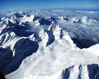
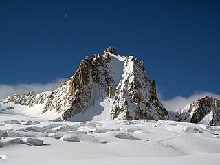
View from the north side
Elevation 3,605 m (11,827 ft)
Traversed by Leslie Stephen and party (1859)
Location Bern, Switzerland
Range Bernese Alps
Coordinates 46°34′20″N8°00′24″E / 46.57222°N 8.00667°E / 46.57222; 8.00667

The Eigerjoch is a high Alpine pass lying between the Mönch (south) and the Eiger (north). The lowest point (3,605 m) on the ridge is named Nördliches Eigerjoch while another pass (3,747 m) located closer to the Mönch is named Südliches Eigerjoch.

Mountain pass Route through a mountain range or over a ridge

A mountain pass is a navigable route through a mountain range or over a ridge. Since many of the world's mountain ranges have presented formidable barriers to travel, passes have played a key role in trade, war, and both human and animal migration throughout Earth's history. At lower elevations it may be called a hill pass. The highest vehicle-accessible pass in the world appears to be Mana Pass, located in the Himalayas on the border between India and Tibet, China.

Mönch mountain in the Bernese Alps

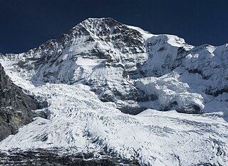
The Mönch at 4,107 metres (13,474 ft) is a mountain in the Bernese Alps, in Switzerland. Together with the Eiger and the Jungfrau, it forms a highly recognisable group of mountains, visible from far away.

Eiger mountain in the Bernese Alps, Switzerland

The Eiger is a 3,967-metre (13,015 ft) mountain of the Bernese Alps, overlooking Grindelwald and Lauterbrunnen in the Bernese Oberland of Switzerland, just north of the main watershed and border with Valais. It is the easternmost peak of a ridge crest that extends across the Mönch to the Jungfrau at 4,158 m (13,642 ft), constituting one of the most emblematic sights of the Swiss Alps. While the northern side of the mountain rises more than 3,000 m (10,000 ft) above the two valleys of Grindelwald and Lauterbrunnen, the southern side faces the large glaciers of the Jungfrau-Aletsch area, the most glaciated region in the Alps. The most notable feature of the Eiger is its 1,800-metre-high (5,900 ft) north face of rock and ice, named Eiger-Nordwand, Eigerwand or just Nordwand, which is the biggest north face in the Alps. This huge face towers over the resort of Kleine Scheidegg at its base, on the homonymous pass connecting the two valleys.

Contents

The Eiger does not lie in the ridge of the Bernese Alps which divides the basins of the Rhone and the Aar, but forms a promontory extending north-east from the Mönch, and is connected with it by a long and high arête, in which jagged teeth of rock project through a coating of ice. At the southern end, where this arete abuts against the shoulder of the Mönch, it overlooks the gently-sloping plateau which forms the summit of the Mönchsjoch, and the descent on the side of the Aletsch Glacier presents no serious difficulty. [1]

Bernese Alps part of the Alps mountain range in Switzerland

The Bernese Alps are a mountain range of the Alps, located in western Switzerland. Although the name suggests that they are located in the Berner Oberland region of the canton of Bern, portions of the Bernese Alps are in the adjacent cantons of Valais, Fribourg and Vaud, the latter being usually named Fribourg Alps and Vaud Alps respectively. The highest mountain in the range, the Finsteraarhorn, is also the highest point in the canton of Bern.

Arête A narrow ridge of rock which separates two valleys

An arête is a narrow ridge of rock which separates two valleys. It is typically formed when two glaciers erode parallel U-shaped valleys. Arêtes can also form when two glacial cirques erode headwards towards one another, although frequently this results in a saddle-shaped pass, called a col. The edge is then sharpened by freeze-thaw weathering, and the slope on either side of the arete steepened through mass wasting events and the erosion of exposed, unstable rock. The word ‘arête’ is actually French for edge or ridge; similar features in the Alps are described with the German equivalent term Grat.

Aletsch Glacier glacier in Switzerland

The Aletsch Glacier or Great Aletsch Glacier is the largest glacier in the Alps. It has a length of about 23 km (14 mi) (2014), has about a volume of 15.4 km3 (3.7 cu mi) (2011), and covers about 81.7 km2 (2011) in the eastern Bernese Alps in the Swiss canton of Valais. The Aletsch Glacier is composed of four smaller glaciers converging at Concordia Place, where its thickness was measured by the ETH to be still near 1 km (3,300 ft). It then continues towards the Rhône valley before giving birth to the Massa. The Aletsch Glacier is – like most glaciers on this world – a retreating glacier. As of 2016, since 1980 it lost 1.3 kilometres (0.81 mi) of its length, since 1870 3.2 kilometres (2.0 mi), and lost also more than 300 metres (980 ft) of its thickness.

First crossing

The first crossing was made by Leslie Stephen and W. and G. S. Mathews, with Ulrich Lauener of Lauterbrunnen and J. B. Croz and M. Charlet of Chamonix. [1]

Leslie Stephen British author, literary critic, and first editor of the Dictionary of National Biography

Sir Leslie Stephen, was an English author, critic, historian, biographer, and mountaineer, and father of Virginia Woolf and Vanessa Bell.

In August 1859, the three enterprising mountaineers above named, failing to perceive any route by which the Jungfraujoch could be attacked with a fair prospect of success, resolved to attempt to pass from the Wengern Alp by the north and east sides of the peak of the Mönch. Starting at 4 a.m. they soon reached the Eiger Glacier, and ascended for some distance along the side nearest to the Eiger. On reaching the very much crevassed middle region of the glacier, some time was lost in the endeavour to force a direct way. The correct course was to cross to the southern bank below the rocks of the Mönch. After a short ascent the form of the crevasses made it expedient to cross back to the opposite side, nearly to the edge of the glacier, here held up by the great rocky buttress of the Eiger, so remarkable from the Wengern Alp. Further progress seemed to be barred by the menacing condition of the seracs; but the difficulties could be avoided by crossing the glacier diagonally a third time to a sort of snow valley, where the crevasses were apparently filled up by avalanches from the Mönch. By this circuitous but not very difficult route the party reached the uppermost plateau of the glacier, lying immediately below the ridge connecting the two peaks. On the side nearest the Monch the ridge was accessible only by extremely long and steep slopes of hard snow. At the end approaching the Eiger the ridge is far easier of access, and this therefore was the first object of attack. On gaining the summit the travellers found themselves at the top of a tremendous precipice overlooking one arm of the Lower Grindelwald Glacier, while the arête to the right connecting them with the Mönch was broken through by so many jagged teeth of rock, and at the same time so narrow and difficult, that many hours would probably have been consumed in passing along it. It was therefore thought expedient to return, and to attempt the ascent by the ice-slope, as it should be called since the névé is so hard and slippery as to make stepcutting very laborious. Ulrich Lauener on that occasion displayed extraordinary strength and endurance, having in 5 hours of uninterrupted work cut 580 steps on an ice slope of from 50 to 52° inclination. That effort sufficed only to enable the party to gain a patch of rock some way below the summit of the ridge, and more than an hour more was expended in reaching the desired goal. Turning to the right along the arête, they finally reached at 6 p.m. the point on the shoulder of the Mönch which forms the summit level of this pass, which was probably the Südliches Eigerjoch. [1]

Jungfraujoch mountain pass

Jungfraujoch is a notable saddle in the Bernese Alps, connecting the two four-thousander peaks Jungfrau and Mönch, at an elevation of 3,466 metres (11,371 ft) above sea level. It is a glacier saddle, on the upper snows of the Aletsch Glacier, and part of the Jungfrau-Aletsch area, situated on the boundary between the cantons of Bern and Valais, halfway between Interlaken and Fiesch.

Eiger Glacier glacier

The Eiger Glacier is a glacier situated on the north-west side of the Eiger in the Bernese Alps of Switzerland. The glacier is within the municipality of Lauterbrunnen in the canton of Bern.

Lower Grindelwald Glacier glacier

The Lower Grindelwald Glacier is a Glacier in the Swiss Bernese Alps, situated to the south-east of Grindelwald. It starts below the Agassizhorn and the Strahlegghörner and is connected with the Finsteraar Glacier via the Finsteraarjoch.

In descending to the Aletsch Glacier the discoverers of this pass were benighted before they could reach the comparative shelter of the Kaulberg cave, and were forced to pass the night on some exposed rocks at the southern base of the Trugberg, where their position in case of bad weather would have been very critical. The Eggishorn was reached on the following morning about 9 a.m. in about 29 hours trom the Wengern Alp. [1]

Trugberg mountain

The Trugberg is a mountain in the Bernese Alps, located south of the Mönch in the canton of Valais, Switzerland. It is located above the Konkordiaplatz where the névé of the Jungfraufirn on the west side and the Ewigschneefeld on the east side converge to form the Aletsch Glacier. Debris accumulating on both sides of the mountain form one of the two important supraglacial moraines of the Aletsch Glacier.

Eggishorn mountain

The Eggishorn is a mountain of the Bernese Alps, located north of Fiesch in the Swiss canton of Valais. A cable car station is located on a secondary summit named Fiescherhorli, 500 metres south of the main peak.

See also

Related Research Articles

Finsteraarhorn mountain in the Bernese Alps

The Finsteraarhorn is the highest mountain in the Bernese Alps in Switzerland and the most prominent peak of Switzerland. The Finsteraarhorn is the ninth-highest mountain and third-most prominent peak in the Alps. In 2001 the whole massif and surrounding glaciers were designated as part of the Jungfrau-Aletsch World Heritage Site.

Wildspitze mountain

Wildspitze is the highest mountain in the Ötztal Alps and in North Tyrol, as well as the second highest mountain in Austria after the Großglockner and in terms of prominence is the fourth summit of the Alps and the fifteenth of Europe.

Dufourspitze highest mountain in Switzerland

The Dufourspitze is the highest peak of Monte Rosa, a huge ice-covered mountain massif in the Alps. Dufourspitze is the highest mountain peak of both Switzerland and the Pennine Alps and is also the second-highest mountain of the Alps and Europe outside the Caucasus. It is located between Switzerland and Italy.

Aiguille de Bionnassay mountain in the Mont-Blanc massif in the Alps

The Aiguille de Bionnassay is a mountain in the Mont Blanc massif of the Alps in France and Italy. It has been described as "one of the most attractive satellite peaks of Mont Blanc", and is located on its western side. The mountain's south and east ridges form the frontier between the two countries, and its summit is a knife-edge crest of snow and ice. Reaching it via any route provides a "splendid and serious snow and ice climb".

Aletschhorn mountain in Switzerland

The Aletschhorn is a mountain in the Alps in Switzerland, lying within the Jungfrau-Aletsch region, which has been designated a World Heritage Site by UNESCO. The mountain shares part of its name with the Aletsch Glacier lying at its foot.

Grünhorn mountain in the Swiss Alps

The Grünhorn is a mountain in the Bernese Alps range of the Swiss Alps. It is located on the ridge between the two largest glaciers of the Alps: the Aletsch Glacier to the west and the Fiescher Glacier to the east. To the south lies the Gross Wannenhorn and, to the north, the Gross Fiescherhorn.

Silberhorn mountain

The Silberhorn is a pyramid-shaped mountain of the Bernese Alps, to the northwest of the Jungfrau of which it is a satellite peak.

Wildstrubel mountain of the Bernese Alps

The Wildstrubel is a mountain of the Alps, straddling the border between the Swiss cantons of Bern and Valais. It forms a large glaciated massif, about 15 km wide, extending between the Rawil Pass and the Gemmi Pass. Along with the Muverans, the Diablerets and the Wildhorn, the Wildstrubel is one the four distinct mountain massifs of the Bernese Alps that lie west of the Gemmi Pass. The massif of the Wildstrubel is at the centre between the valleys of Simmental (BE), Engstligental (BE) and the Rhone (VS), the exact location of the tripoint being the summit of the Schneehorn. It comprises several distinct summits, including the Wetzsteinhorn, the Rohrbachstein, the Weisshorn, the Pointe de la Plaine Morte, Mont Bonvin, the Trubelstock and the Schneehorn. The main crest with the almost equally high summits of the Mittelgipfel and the Grossstrubel forms an amphitheatre oriented eastward which ends at the Steghorn and the Daubenhorn. This area encloses the Wildstrubel Glacier. To the southwest, the Wildstrubel overlooks the high plateau of the Plaine Morte Glacier, which also includes an unnamed lake below the Schneehorn.

Weisshorn mountain in the Pennine Alps

The Weisshorn is a major peak of the Swiss Alps, culminating at 4,506 metres above sea level. It is part of the Pennine Alps and is located between the valleys of Anniviers and Zermatt in the canton of Valais. In the latter valley, the Weisshorn is one of the many 4000ers surrounding Zermatt, with Monte Rosa and the Matterhorn.

Jungfrau-Aletsch protected area

The Jungfrau-Aletsch protected area is located in south-western Switzerland between the cantons of Berne and Valais. It is a mountainous region in the easternmost side of the Bernese Alps, containing the northern wall of Jungfrau and Eiger, and the largest glaciated area in western Eurasia, comprising the Aletsch Glacier. The Jungfrau-Aletsch protected area is the first World Natural Heritage site in the Alps, it was inscribed in 2001.

Strahlkogel mountain

The Strahlkogel, at 3,288 m (AA), is the highest peak in the Larstiger Mountains, a subgroup of the Stubai Alps in the Austrian state of Tyrol. The Strahlkogel is also the highest mountain in the municipality of Umhausen. Its name comes from its great, white, light-reflecting, quartz layers, which allegedly cause the mountain to "radiate" (strahlen). It has the shape of a well-proportioned, steep and pointed pyramid. Ascending the Strahlkogel is difficult and it is thus only rarely visited, unlike the neighbouring 3,287-metre-high Breiter Grieskogel. The first ascent of the mountain was in 1833 by Peter Carl Thurwieser, but his route and the precise circumstances of the climb have not been passed on. On 28 August 1887 Ludwig Purtscheller and Fritz Drasch from Salzburg climbed the mountain. Their route led along the west arête. Today, this is the normal route and easiest way to reach the summit.

Großer Möseler mountain

The Große Möseler, also called the Mösele, is a mountain, 3,480 m (AA), and thus the second highest peak in the Zillertal Alps after the Hochfeiler. It lies on the Zillertal main ridge which forms the border here between the Austrian state of Tyrol and the Italian province of South Tyrol. Its great size makes it the dominant mountain in the area. Seen from the northwest it appears like a firn-covered dome; but from the northeast as a regularly shaped cone of rock. Prominent arêtes radiate from the peak to the northwest, east and south. The mountain is easily ascended from the Furtschaglhaus and is often visited as a result. It was first climbed on 16 June 1865 by G. H. Fox, Douglas William Freshfield and Francis Fox Tuckett with mountain guides, François Devouassoud from Chamonix and Peter Michel from Grindelwald, as well as two unknown bearers.

Ruderhofspitze mountain

At 3,474 m (AA) the Ruderhofspitze is the fourth highest mountain in the Stubai Alps in Austria. It is part of the Alpein Mountains and lies in the Austrian state of Tyrol. As a result of its topographic isolation and good all-round views it is one of the most visited mountains in the Stubai. An almost two-kilometre-long arête, the Grawawand, runs away from the summit to the east. Less prominent ridges run south and northwestwards from the Ruderhofspitze. The peak was first ascended on 30 August 1864 by Karl Baedeker, Anton von Ruthner and mountain guides Pankraz Gleinser and Alois Tanzer.

Tour Ronde mountain

The Tour Ronde is a mountain in the Mont Blanc massif of the Alps, situated on the border between France and Italy. It is a prominent mountain, some 3.5 km north-east of Mont Blanc, but is effectively part of a continuation of the south eastern spur of Mont Maudit which forms a frontier ridge between the two countries. It is easily accessible to mountaineers and provides not only a very good viewpoint from its summit of the Brenva face and the major peaks on the southern side of Mont Blanc, but it also offers a popular introduction to alpine climbing of all grades, including a north face ascent.

References

  1. 1 2 3 4 John Ball, The Alpine guide, Central Alps, p. 108, 1866, London