Phungling Municipality is a municipality located in Taplejung District in the Province No. 1 of Nepal. The municipality was formed merging the then two Village Development Committees of Phungling and Dokhu in May 2014. At the time of the 2011 Nepal census it had a population of 19,085 people and 4,480 individual households.

Darchula District (Nepali: दार्चुला जिल्लाpronounced [ˈdaɾt͡sula], a part of Sudurpashchim Province, is one of the nine districts of province and one of seventy-seven districts of Nepal. The district, with Khalanga as its district headquarters, covers an area of 2,322 km2 and has a population of 133,274. Darchula Lies in the west-north corner of the country.
Kohalpur is a municipality in Banke District of Lumbini province of Nepal. The municipality was established on 18 May 2014 merging the existing two Village Development Committees i.e. Rajhena and Kohalpur. The town is in East-West highway and one of the fastest developing places in Nepal. A neighboring city Nepalgunj is on South (16 km), with Ghorahi city (135 km) to west in Dang District and further 6 km is the Indian border. In fact it is a growing city in the western region of Nepal. It has a junction to diverse the roadway transport to east, west, north and south from the city.

Ilam is one of four urban municipalities of Ilam District, which lies in the Mahabharata hilly range of Province No. 1, eastern Nepal. Ilam also acts as the headquarters of Ilam District. Being the largest producer region for Nepali tea, its tea farms comprise a major tourist attraction in Province No. 1. Ilam is also famous for its natural scenery and landscapes as well as its diverse agricultural economy which specializes in horticultural crop production.
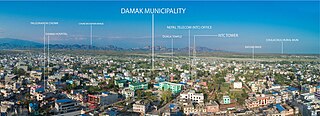
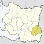
Damak, a city in eastern Nepal is one of the oldest municipalities in Jhapa District in Province No. 1 of Nepal. It is situated between the Ratuwa River in the east and the Maawa River in the west. It has Sivalik Hills in its north and ends with the intersection of Ratuwa River and Maawa River in the south. Mahendra Highway crosses this municipality nearly bisecting it. It is the largest city in Jhapa District as well as in Province No. 1 with a population of 75,743 in 2011 A.D
Birendranagar officially Birendranagar Municipality is a city in Surkhet District in Karnali Province of Nepal. It is the District headquarter of Surkhet District and also the Capital city of Karnali province. As of March 2022, Birendranagar has a population of 154,886 making it the 17th largest city of Nepal. It is the largest city of karnali province and 7th largest in Western Nepal. It is one of the fastest growing cities of Nepal. Birendranagar is the destination of two national highways i.e Ratna Highway and Karnali Highway. It is one of the constituent city of Ratna Highway Metropolitan Areas along with Nepalgunj and Kohalpur. Birendranagar is compromise of beautiful panoramic view of Mahabharata and chure ranges and the plain of inner terai. Birendranagar is a major trade center in mid-western Nepal and is considered as the most expensive city to live in Nepal.

Triyuga is one of eight municipalities of Udayapur district of the Province No. 1 of Nepal. Gaighat is the headquarter of the municipality. According to the 1991 Nepal census, it had a population of 55,291. According to the 2011 Nepal census, Triyuga had 87,557 inhabitants. According to the 2021 Nepal census the initial population of the municipality is 104,375. It is divided into 16 wards. Triyuga Municipality was established on B.S. Chaitra 13, 2053. It was named after Triyuga River. A river which flows through the town. Triyuga is the 3rd largest municipality in Nepal and 1st largest in Province No. 1 in term of size (area). The total area of the municipality is 547.43 square kilometres (211.36 sq mi)

Besishahar is a municipality and the district headquarters of Lamjung District in Gandaki Province, Nepal. The Besishahar Municipality was formed by merging the existing Village Development Committees i.e. Besishahar, Gaunshahar, Udipur, Chandisthan, Baglungpani, Bajhakhet, Hiletaksar and Chiti and have 11 wards. Here are different castes and religions. So they have different culture. This municipality has a sub-tropical climate with deciduous forests. Annapurna II, Machhapuchhre, Lamjung Himal can be viewed from north of Besishahar Municipality.

Solududhkunda (earlier:Dudhkunda) is the only municipality of Solukhumbu District. Located in Province No. 1 of Nepal. The town of Salleri, which is located within the municipality is the headquarter of Solukhumbu District It was formed in 2014 by merging four VDCs: Salleri, Garma, Loding Tamakhani and Beni and was divided into 9 wards. Total area of the municipality had 254.3 square kilometres (98.2 sq mi) and population of municipality had 20,399 individuals living in 5,368 households.
Sandhikharka Municipality is the headquarter of Arghakhanchi District which lies in Lumbini Province of Nepal. The former village development committee (VDC) was converted into a municipality on 18 May 2014 by merging the existing Sandhikharka, Wangla, Narapani, Khanchikot, Kimadada, Argha and Dibharna VDCs evdo. It is located, in a valley surrounded by hills, in the western part of the capital, Kathmandu.
Naubise is a village development committee in Dhading District in the Bagmati Zone of central Nepal. At the time of the 2011 Nepal census it had a population of 25621 and had 3239 houses in it.
Khaskarkando is a town in Banke District in the Bheri Zone of south-western Nepal. At the time of the 1991 Nepal census it had a population of 4,582 and had 769 houses in the town. Now, it is a part of Nepalgunj sub-metropolitan city.
Kavre Nitya Chandeswori popularly known as "Kavre" is a village development committee in Kavrepalanchok District in the Bagmati Zone of central Nepal. Two of its V.D.C's are included in Dhulikhel Municipality in the year 2015 A.D. At the time of the 2011 Nepal census it had a population of 4,927 in 1,042 individual households.
Sangrumba साङरुम्बा is a town and Village Development Committee in Ilam District in the Province No. 1 of eastern Nepal. At the time of the 1991 Nepal census it had a population of 4,607 persons living in 839 individual households. According to the VDC report of 2068 BS, the total population was 6,288 and the total number of households was 1,227, an average of 5.12 members per household.
Lalbandi is a Municipality in Sarlahi District in the Janakpur Zone of south-eastern Nepal. The municipality was established on 18 May 2014 by merging the existing Parwanipur VDC, Netragung vdc, Jabdi, Lalbandi and Pattharkot VDCs. At the time of the 2021 Nepal Census, it had a population of 67,507 living in 13905 individual households. There are 17 wards in this municipality. It is the largest municipality in Sarlahi district. The office of this municipality is in ward no.6 Located in the Lalbandi. Lalbandi Bazar, located on the East West Mahendra highway, is one of the main trading areas within the municipal area. Bordering East Ishwarpur Municipality, West Hariwan and Haripur Municipality, North Sindhuli District and bordering Haripur and Ishwarpur in the south, Lalbandi Bazar is the main trading site of the district.

Surunga is a trade center of Jhapa District. It is located in Kankai Municipality in Jhapa District in the Province No. 1 of south-eastern Nepal. At the time of the 1991 Nepal census it had a population of 16,747 people living in 2996 individual households. Surunga is one of the rapidly developing towns of Jhapa district. It is situated on the bank of the Kankai River.
Palung (पालुङ्ग) is an ancient market place in Thaha Municipality in Makwanpur District in the Bagmati Province of Nepal. At the time of the 2011 Nepal census it had a population of 5,603 people living in 1,236 individual households.

Phidim Municipality is the headquarters of the Panchthar District in the Province No. 1 of eastern Nepal. Phidim was upgraded to a 'municipality' from a 'village', when a development committee merged with other VDCs - including the Phidim, Chokmagu and Siwa villages - on May 18, 2014. It offers a route for trekkers and locals, who travel to and from the Taplejung district bordering with the Tibetan Autonomous Region of China. It is also a commercial hub for the rural surroundings.
Banganga is a municipality in Kapilvastu District in the Lumbini Zone of southern Nepal. Banganga Municipality has total of 233.6 km2. According to the 2011 census, total population of the municipality is 75, 242 with population density of 322 person per km2 and density without forest is 804 persons per km2.

Kawasoti (Nepali: कावासोती) is a municipality in Nawalpur District, Gandaki Province, Nepal. It is 31 km (19 mi) west of Bharatpur and 85 km (53 mi) east of Butwal, approximately on the middle of Mahendra Highway. The Naryani River flows south of it, and the Mahabharat Range is north of it.