
Patillas is a municipality of Puerto Rico (U.S.) located in the southeastern coast, south of San Lorenzo; west of Yabucoa and Maunabo; and east of Guayama and Arroyo. It is spread over 15 wards and Patillas Pueblo. It is part of the Guayama Metropolitan Statistical Area.

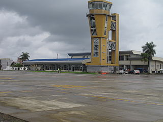
El Edén International Airport is an international airport serving Armenia, the capital of the Quindío Department of Colombia. The airport is 13 kilometres (8.1 mi) southwest of Armenia, near the town of La Tebaida. It handles domestic flights to Bogotá and Medellín and international flights to Panama City and Fort Lauderdale, Florida.
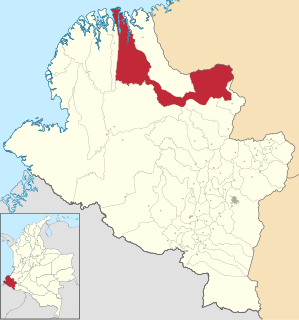
El Charco is a town and municipality in the Nariño Department, Colombia.

Guaymaral Airport is a high-elevation airport in the north of Bogotá, Colombia, also serving the towns of Cota and Chía. The runway is 15 kilometres (9.3 mi) northeast of Bogota's El Dorado International Airport.
La Macarena Airport, also known as El Refugio Airport, is an airport serving the Guayabero River town of La Macarena in the Meta Department of Colombia.

El Embrujo Airport is an airport serving Providencia Island, Colombia. The airport is located in the north east side of the island, in the limits of the Old Providence McBean Lagoon National Natural Park.
Germán Olano Airport is an airport serving Puerto Carreño, the capital of Vichada Department in Colombia. It is also known as Puerto Carreño Airport. The airport is 1.5 kilometres (0.93 mi) west of and parallels the Orinoco River, locally Colombia's border with Venezuela.
Caucayá Airport is an airport serving the river town of Puerto Leguízamo in the Putumayo Department of Colombia. Puerto Leguízamo is on the Putumayo River, locally the border with Peru.
El Caraño Airport is an airport serving Quibdó in the Chocó Department of Colombia.

Jorge Enrique González Torres Airport is an airport serving San José del Guaviare, the capital of the Guaviare Department of Colombia. The runway is just north of the town and parallels the Guaviare River.

El Estrecho Airport is an airport serving the town of El Estrecho (es) in the Loreto Region of Peru. The town is on the Putumayo River, which forms most of the border between Colombia and Peru.
Furatena Airport is an airport serving the emerald region of the western emerald belt and town of Quípama in the Boyacá Department of Colombia. The airport is four nautical miles west of Muzo Airport.
Miraflores Airport is an airport serving the town of Miraflores, in the Guaviare Department of Colombia. The runway and town are on the east bank of the Vaupés River, a tributary of the Rio Negro River.
El Carmen de Bolívar Airport is an airport serving the town of El Carmen de Bolívar, in the Bolívar Department of Colombia. The airport is 3 kilometres (1.9 mi) south of the town.
Las Flores Airport is an airport serving the Magdalena River port of El Banco, in the Magdalena Department of Colombia. The airport is 5 kilometres (3.1 mi) north of the town.
Cicuco Airport is an airport serving the town of Cicuco in the Bolívar Department of Colombia. The airport is near the Ciénega El Medio, an arm of the Magdalena River.
El Troncal Airport is an airport serving the river town of Arauquita in the Arauca Department of Colombia.

The Malpelo Plate is a small tectonic plate located off the coasts west of Ecuador and Colombia. It is the 57th plate to be identified. It is named after Malpelo Island, the only emerged part of the plate. It is bounded on the west by the Cocos Plate, on the south by the Nazca Plate, on the east by the North Andes Plate, and on the north by the Coiba Plate, separated by the Coiba Transform Fault (CTF). This microplate was previously assumed to be part of the Nazca Plate. The Malpelo Plate borders three major faults of Pacific Colombia, the north to south striking Bahía Solano Fault in the north and the Naya-Micay and Remolino-El Charco Faults in the south.

The Naya-Micay Fault is a dextral oblique thrust fault in the departments of Cauca and Valle del Cauca in Colombia. The fault has a total length of 158.2 kilometres (98.3 mi) and runs along an average northeast to southwest strike of 034.1 ± 12 in the Tumaco Basin along the Pacific Coast of Colombia.
The Remolino-El Charco Fault is a dextral strike-slip fault in the department of Nariño in Colombia. The fault has a total length of 148.7 kilometres (92.4 mi) and runs along an average northeast to southwest strike of 046.4 ± 6 in the Tumaco Basin along the Pacific Coast of Colombia.


