El Ghicha

Last updated
El Ghicha
الغيشة
Commune and town
Oued El Ghicha Laghouat.jpg
Oued El Ghicha
Dz - 03 - El Ghicha.svg
CountryFlag of Algeria.svg  Algeria
Province Laghouat Province
District El Ghicha [1]
Area
  Total280 sq mi (730 km2)
Population
 (2008 [2] )
  Total6,079
  Density22/sq mi (8.3/km2)
Time zone UTC+1 (CET)

El Ghicha is a town and commune in Laghouat Province, Algeria. According to the 1998 census, it has a population of 5,719. [3]

Related Research Articles

Brida District District in Laghouat, Algeria

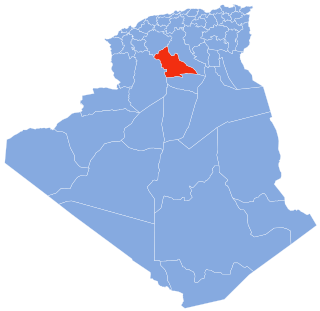
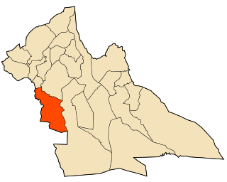
Brida is a district in Laghouat Province, Algeria. It was named after its capital, Brida.

Aïn Madhi District District in Laghouat, Algeria

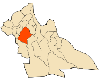
Aïn Madhi is a district in Laghouat Province, Algeria. It was named after its capital, Aïn Madhi.

Ksar El Hirane District District in Laghouat, Algeria

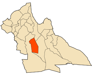
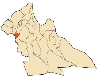
Ksar El Hirane is a district in Laghouat Province, Algeria. It was named after its capital, Ksar El Hirane.

El Ghicha District District in Laghouat Province, Algeria

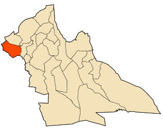
El Ghicha District is a district of Laghouat Province, Algeria.

Aïn Madhi Commune and town in Laghouat Province, Algeria

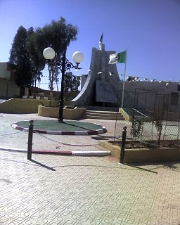
Aïn Madhi is a town and commune in Laghouat Province, Algeria, and the seat of Aïn Madhi District. According to the 1998 census it has a population of 6,263.

Aïn Sidi Ali Commune and town in Laghouat Province, Algeria

Aïn Sidi Ali is a town and commune in Laghouat Province, Algeria. According to the 1998 census it has a population of 4,220.

Brida Commune and town in Laghouat Province, Algeria

Brida is a town and commune in Laghouat Province, Algeria. According to the 1998 census, it has a population of 5,742.

El Assafia Commune and town in Laghouat Province, Algeria

El Assafia is a town and commune in Laghouat Province, Algeria. According to the 1998 census, it has a population of 4,389.

El Houaita Commune and town in Laghouat Province, Algeria

El Houaita is a town and commune in Laghouat Province, Algeria. According to the 1998 census it has a population of 1,290.

Hadj Mechri Commune and town in Laghouat Province, Algeria

Hadj Mechri is a town and commune in Laghouat Province, Algeria. According to the 1998 census it has a population of 6,197.

Hassi Delaa Commune and town in Laghouat Province, Algeria

Hassi Delaa is a town and commune in Laghouat Province, Algeria. According to the 1998 census, it has a population of 6,930.

Kheneg Commune and town in Laghouat Province, Algeria

Kheneg is a town and commune in Laghouat Province, Algeria.

Ksar El Hirane Commune and town in Laghouat Province, Algeria

Ksar El Hirane is a town and commune in Laghouat Province, Algeria. According to the 1998 census it has a population of 14,910.

Oued Morra Commune and town in Laghouat Province, Algeria

Oued Morra is a town and commune in Laghouat Province, Algeria. According to the 1998 census it has a population of 4,748.

Oued MZi Commune and town in Laghouat Province, Algeria

Oued M'Zi is a town and commune in Laghouat Province, Algeria. According to the 1998 census it has a population of 1,786.

Sidi Bouzid, Algeria Commune and town in Laghouat Province, Algeria

Sidi Bouzid, Algeria is a town and commune in Laghouat Province, Algeria. According to the 1998 census it has a population of 3864.

Tadjrouna Commune and town in Laghouat Province, Algeria

According to Wikipedia. Tadjrouna is a town and commune in Laghouat Province, Algeria. According to the 1998 census, it has a population of 3,597.

Taouila Commune and town in Laghouat Province, Algeria

Taouila is a town and commune in Laghouat Province, Algeria. According to the 1998 census, it has a population of 2,634.

Beidha (commune and town) Commune and town in Laghouat Province, Algeria

Beidha is a town and commune in Laghouat Province, Algeria.

Bennasser Benchohra Commune and town in Laghouat, Algeria

Bennasser Benchohra is a town and commune in Laghouat Province, Algeria. As of 2008, the town's population was 9,621 people.

References

  1. "Décret executif n° 91-306 du 24 août 1991 fixant la liste des communes animées par chaque chef de daïra. 03 - Wilaya de Laghouat" [List of municipalities animated by each District chief: 03 - Laghouat Province](PDF) (in French). Journal officiel de la République Algérienne. 4 September 1991. p. 1294. Archived (PDF) from the original on 2019-10-25. Retrieved 2019-11-03.
  2. "Wilaya de Laghouat: répartition de la population résidente des ménages ordinaires et collectifs, selon la commune de résidence et la dispersion" (PDF) (in French). Archived (PDF) from the original on 2011-11-13. Retrieved 2019-11-03.. Data from the 2008 General Population and Housing Census on the site of the NOS Algeria.
  3. Statoids

Coordinates: 33°56′N2°09′E / 33.933°N 2.150°E / 33.933; 2.150