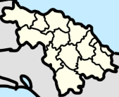
Villa Clara is one of the provinces of Cuba. It is located in the central region of the island bordering on the Atlantic Ocean to the north, Matanzas Province to the west, Sancti Spiritus Province to the east, and Cienfuegos Province to the South. Villa Clara shares with Cienfuegos and Sancti Spiritus on the south the Escambray Mountain Range. Its main cities are Santa Clara, Remedios, Sagua La Grande, Camajuani, Caibarién, Ranchuelo, Placetas, and Manicaragua.
The Escambray Mountains are a mountain range in the central region of Cuba, in the provinces of Sancti Spíritus, Cienfuegos and Villa Clara.

Baracoa, whose full original name is: Nuestra Señora de la Asunción de Baracoa, is a municipality and city in Guantánamo Province near the eastern tip of Cuba. It was visited by Admiral Christopher Columbus on November 27, 1492, and then founded by the first governor of Cuba, the Spanish conquistador Diego Velázquez de Cuéllar on August 15, 1511. It is the oldest Spanish settlement in Cuba and was its first capital.

Camagüey is a city and municipality in central Cuba and is the nation's third-largest city with more than 321,000 inhabitants. It is the capital of the Camagüey Province.

Cienfuegos, capital of Cienfuegos Province, is a city on the southern coast of Cuba. It is located about 250 km (160 mi) from Havana and has a population of 164,924. Since the late 1960s, Cienfuegos has become one of Cuba's main industrial centers, especially in the energy and sugar sectors. The city is dubbed La Perla del Sur. Despite being known as an industrial city of factories and various nuclear/electrical plants, and the name Cienfuegos literally translating to "one hundred fires", the city actually takes its name from the surname of Asturian-born José Cienfuegos Jovellanos, Captain General of Cuba (1816–19).

Santa Clara is the capital city of the Cuban province of Villa Clara. It is centrally located in the province and Cuba. Santa Clara is the fifth-most populous Cuban city, with a population of nearly 250,000.

Cruces is a municipality and town in Cienfuegos Province, Cuba. It is the home of the Mal Tiempo National Park which commemorates a battle in the 1895 War of Independence.
Topes de Collantes is a nature reserve park in the Escambray Mountains range in Cuba. It also refers to the third highest peak in the reserve, where a small settlement and tourist center is located, all sharing the same name.

Cumanayagua is a municipality and town in the Cienfuegos Province of Cuba. It is located in a valley near the Guamuhaya Mountains (usually these mountains are referred as Escambray Mountains, 23 kilometres east of Cienfuegos, the provincial capital.

Manicaragua is a municipality and mountain town in the Villa Clara Province of Cuba. It is located in the Escambray Mountains at the southern part of Villa Clara, bordering the provinces of Cienfuegos to the west and Sancti Spíritus to the east.
The following outline is provided as an overview of and topical guide to Cuba:

Mataguá is a Cuban village and consejo popular of the municipality of Manicaragua, in Villa Clara Province. With a population of ca. 10,000, it is the most populated village in the municipality after Manicaragua.

The Hanabanilla Dam is an embankment dam on the Hanabanilla River near the village of El Salto del Hanabanilla in Villa Clara Province, Cuba. The purpose of the dam is to provide water for irrigation and municipal uses and to generate hydroelectric power.
Güinía de Miranda, sometimes shortened as Güinía, is a Cuban village and consejo popular of the municipality of Manicaragua, in Villa Clara Province. It has a population of circa 3,000 and the council's administrative territory covers an area of 114.2 km².

Jibacoa is a Cuban village and consejo popular of the municipality of Manicaragua, in Villa Clara Province. As of 2004, it had a population of 3,101; and the council's administrative territory covers an area of 78.5 km2.
Pico San Juan is the highest point of the central area of the island of Cuba with 1,140 meters above sea level.

Manajanabo is a town and ward in Santa Clara, Cuba. Manajanabo lies on the Minerva Lake.
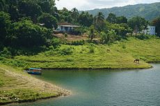 Some houses and medical clinic of Hanabanilla village visible from the lake's courtain.
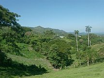 View of the Escambray Mountains north side from the village.
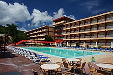 View of a 70's built Hanabanilla Hotel grounds.
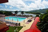