Related Research Articles

Uraninite, also known as pitchblende, is a radioactive, uranium-rich mineral and ore with a chemical composition that is largely UO2 but because of oxidation typically contains variable proportions of U3O8. Radioactive decay of the uranium causes the mineral to contain oxides of lead and trace amounts of helium. It may also contain thorium and rare-earth elements.

Kakadu National Park is a protected area in the Northern Territory of Australia, 171 km (106 mi) southeast of Darwin. It is a World Heritage Site. Kakadu is also gazetted as a locality, covering the same area as the national park, with 313 people recorded living there in the 2016 Australian census.

The Ranger Uranium Mine was a uranium mine in the Northern Territory of Australia. The site is surrounded by, but separate from Kakadu National Park, 230 km east of Darwin. The orebody was discovered in late 1969, and the mine commenced operation in 1980, reaching full production of uranium oxide in 1981 and ceased stockpile processing on 8 January 2021. Mining activities had ceased in 2012. It is owned and operated by Energy Resources of Australia (ERA), a public company 86.33% owned by Rio Tinto Group, the remainder held by the public. Uranium mined at Ranger was sold for use in nuclear power stations in Japan, South Korea, China, UK, France, Germany, Spain, Sweden and the United States.
Alligator Rivers is the name of an area in an Arnhem Land region of the Northern Territory of Australia, containing three rivers, the East, West, and South Alligator Rivers. It is regarded as one of the richest biological regions in Australia, with part of the region in the Kakadu National Park. It is an Important Bird Area (IBA), lying to the east of the Adelaide and Mary River Floodplains IBA. It also contains mineral deposits, especially uranium, and the Ranger Uranium Mine is located there. The area is also rich in Australian Aboriginal art, with 1500 sites. The Kakadu National Park is one of the few World Heritage sites on the list because of both its natural and human heritage values. They were explored by Lieutenant Phillip Parker King in 1820, who named them in the mistaken belief that the crocodiles in the estuaries were alligators.

Shinkolobwe, or Kasolo, or Chinkolobew, or Shainkolobwe, was a radium and uranium mine in the Haut-Katanga Province of the Democratic Republic of the Congo (DRC), located 20 km (12.4 mi) west of Likasi, 20 km (12.4 mi) south of Kambove, and about 145 km (90.1 mi) northwest of Lubumbashi.

Uranium mining is the process of extraction of uranium ore from the ground. Over 50 thousand tons of uranium were produced in 2019. Kazakhstan, Canada, and Australia were the top three uranium producers, respectively, and together account for 68% of world production. Other countries producing more than 1,000 tons per year included Namibia, Niger, Russia, Uzbekistan, the United States, and China. Nearly all of the world's mined uranium is used to power nuclear power plants. Historically uranium was also used in applications such as uranium glass or ferrouranium but those applications have declined due to the radioactivity of uranium and are nowadays mostly supplied with a plentiful cheap supply of depleted uranium which is also used in uranium ammunition. In addition to being cheaper, depleted uranium is also less radioactive due to a lower content of short-lived 234
U and 235
U than natural uranium.
The Key Lake mine is a former uranium mine in Saskatchewan, Canada. It is 570 kilometres (350 mi) north of Saskatoon by air on the southern rim of the uranium-rich Athabasca Basin. Key Lake was initially developed to open-pit mine two nearby uranium ore deposits: the Gaertner deposit and the Deilmann deposit. Mining of this ore ceased in the late 1990s; the Key Lake mill now processes uranium ore from the McArthur River mine and from existing stockpiles on site. High-grade ore from McArthur river is blended with lower grade local rock before being passed through the mill. The mill has a permitted annual production capacity of 25 million pounds of U3O8. In addition, ammonium sulfate fertilizer is produced as a byproduct from used reagents. The pits of the mined out local deposits are being used as mill tailings management facilities.

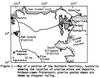
Kakadu National Park, located in the Northern Territory of Australia, possesses within its boundaries a number of large uranium deposits. The uranium is legally owned by the Australian Government, and is sold internationally, having a large effect on the Australian economy. The mining has been controversial, due to the widespread publicity regarding the potential danger of nuclear power and uranium mining, as well as because of objections by some Indigenous groups. This controversy is significant because it involves a number of important political issues in Australia: Native Title, the environment, and Federal-State-Territory relations.
Uranium mining in the United States produced 173,875 pounds (78.9 tonnes) of U3O8 in 2019, 88% lower than the 2018 production of 1,447,945 pounds (656.8 tonnes) of U3O8 and the lowest US annual production since 1948. The 2019 production represents 0.3% of the anticipated uranium fuel requirements of the US's nuclear power reactors for the year.

Uranium mining in Colorado, United States, goes back to 1872, when pitchblende ore was taken from gold mines near Central City, Colorado. The Colorado uranium industry has seen booms and busts, but continues to this day. Not counting byproduct uranium from phosphate, Colorado is considered to have the third largest uranium reserves of any US state, behind Wyoming and New Mexico.

Uranium ore deposits are economically recoverable concentrations of uranium within the Earth's crust. Uranium is one of the most common elements in the Earth's crust, being 40 times more common than silver and 500 times more common than gold. It can be found almost everywhere in rock, soil, rivers, and oceans. The challenge for commercial uranium extraction is to find those areas where the concentrations are adequate to form an economically viable deposit. The primary use for uranium obtained from mining is in fuel for nuclear reactors.

Uranium mining in Arizona has taken place since 1918. Prior to the uranium boom of the late 1940s, uranium in Arizona was a byproduct of vanadium mining of the mineral carnotite.
SAG/SDAG Wismut was a uranium mining company in East Germany during the time of the Cold War. It produced a total of 230,400 tonnes of uranium between 1947 and 1990 and made East Germany the fourth largest producer of uranium ore in the world at the time. It was the largest single producer of uranium ore in the entire sphere of control of the USSR. In 1991 after German reunification it was transformed into the Wismut GmbH company, owned by the Federal Republic of Germany, which is now responsible for the restoration and environmental cleanup of the former mining and milling areas. The head office of SDAG Wismut / Wismut GmbH is in Chemnitz-Siegmar.
The Nabarlek Mine is a uranium mine in the Northern Territory of Australia which was productively worked only in 1979. The deposit sits within the Alligator Rivers Uranium Field approximately 62 kilometres (39 mi) northeast of Jabiru. It was discovered by Queensland Mines Limited in 1970 by following up an intense airborne radiometric anomaly.
The Kintyre uranium project is located 60 km south of the Telfer gold mine and 260 km northeast of Newman at the western edge of the Great Sandy Desert in the East Pilbara region of Western Australia.
Lake Way is a dry saline lake located in the Mid West region of Western Australia, approximately 15 kilometres (9.3 mi) south of Wiluna. It also gives its name to a nearby cattle station, the Lake Way Station.
The Yeelirrie uranium project is a uranium deposit located approximately 70 km southwest of Wiluna, in the Mid West region of Western Australia. The name Yeelirrie is taken from the local sheep station.
The world's largest producer of uranium is Kazakhstan, which in 2019 produced 43% of the world's mining output. Canada was the next largest producer with a 13% share, followed by Australia with 12%. Uranium has been mined in every continent except Antarctica.
COMINAK is a national uranium mining company of Niger.
Coronation Hill is a sandstone outcrop within Kakadu National Park in the Northern Territory of Australia.
References
- ↑ Doering, C.; Ryan, B.; Bollhöfer, A.; Sellwood, J.; Fox, T.; Pfitzner, J. (2010). "Internal Report 586: Results of gamma dose rate surveys at remediated, former uranium mining and milling sites in the South Alligator River Valley". Canberra, Australia: Department of Sustainability, Environment, Water, Population and Communities. Retrieved 3 May 2011.
- ↑ Eupene, Geoff (April 2009). "Obituary: William Joseph (Joe) Fischer AM" (PDF). The AusIMM Bulletin. Australasian Institute of Mining and Metallurgy: 91–92. ISSN 1034-6775 . Retrieved 13 September 2016.
- ↑ Porter, C.A. (July 1988). "Coronation Hill Joint Venture - El Sherana/El Sherana West: compilation and assessment of uranium data". GEMIS - Geoscience Exploration and Mining Information System. Darwin, NT: Northern Territory Geological Survey. Retrieved 13 September 2016.
- ↑ McKay, Aden D.; Miezitis, Yanis (2001). Australia's Uranium Resources, Geology and Development of Deposits (PDF). Canberra, ACT: AGSO - Geoscience Australia. p. 78. ISBN 0-642-46716-1 . Retrieved 13 September 2016.
- ↑ Allam, Lorena (4 April 2010). "No ordinary piece of bush: the high price of Coronation Hill". ABC. Retrieved 4 November 2023.
- ↑ Chan, Gabrielle (31 December 2015). "Cabinet papers 1990-91: Hawke's fight to keep mining out of Kakadu helped unseat him". The Guardian. Guardian News & Media Limited. Retrieved 4 November 2023.
- ↑ Allam, Lorena (4 April 2010). "No ordinary piece of bush: the high price of Coronation Hill". ABC. Retrieved 4 November 2023.
- ↑ "Hawke stands by decision on Kakadu". Nine Entertainment Co. AAP. 6 February 2013. Retrieved 4 November 2023.
- ↑ "Other uranium mines in the Alligator Rivers Region". Department of Climate Change, Energy, the Environment and Water. Retrieved 6 November 2023.
- ↑ "Kakadu National Park". UNESCO . Retrieved 4 November 2023.