
Johnson County is a county located in western portion of the U.S. state of Missouri. As of the 2010 census, the population was 52,595. Its county seat is Warrensburg. The county was formed December 13, 1834 from Lafayette County and named for Vice President Richard M. Johnson.

Addison is an incorporated town in Dallas County, Texas, in the United States. Addison is situated to the immediate north of the city of Dallas. The town's population was 13,056 at the 2010 census. Addison and Flower Mound were the only two Texas towns with a population greater than 10,000 in the 2010 census; since then the towns of Prosper and Trophy Club have also exceeded 10,000 in population estimates. Addison is best-known within the Dallas–Fort Worth–Arlington metroplex region for its abundance of restaurants and nightlife.

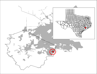
Balch Springs is a city in Dallas County, Texas, United States. It is an inner-ring suburb of Dallas and part of the Dallas–Fort Worth metroplex. The population was 23,728 at the 2010 census.
Arcola is a city in Fort Bend County, Texas, United States, within the Houston–Sugar Land–Baytown metropolitan area. The population was 1,642 at the 2010 census, up from 1,048 at the 2000 census.

San Juan is a city in Hidalgo County, Texas, United States. As of the 2010 census the population was 33,856, up from 26,229 in 2000. It is part of the McAllen–Edinburg–Mission and Reynosa–McAllen metropolitan areas.
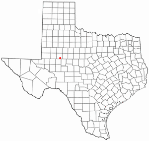
Forsan is a city in Howard County, Texas, United States. The population was 210 at the 2010 census.

Dumas is a city in Moore County, Texas, United States. The population was 14,691 at the 2010 census. It is the county seat of Moore County. Located about 50 miles north of Amarillo, the city is named for its founder, Louis Dumas (1856–1923). Dumas Avenue, the main thoroughfare, is also United States Highways 287 and 87.

Falcon Village is a census-designated place (CDP) in Starr County, Texas, United States. The population was 47 at the 2010 census.

Combine is a city in Dallas and Kaufman counties in the U.S. state of Texas. The population was 1,942 at the 2010 census.

Seagoville is a city in Dallas County, Texas, United States, and a suburb of Dallas. A small portion of Seagoville extends into Kaufman County. The population was 14,835 at the 2010 census. The city is located along U.S. Highway 175, 10 miles (16 km) from downtown Mesquite.

Mission Bend is a census-designated place (CDP) around Texas State Highway 6 within the extraterritorial jurisdiction of Houston in Fort Bend and Harris counties in the U.S. state of Texas; Mission Bend is 4 miles (6 km) northwest of the city hall of Sugar Land and 20 miles (32 km) southwest of Downtown Houston. The population was 36,501 at the 2010 census.

The Birdville Independent School District is a K-12 public school district based in Haltom City, Texas (USA). The name derives from a former community in the area, which later became part of Haltom City.

Magnolia Park is an area of the East End, Houston, Texas, located near the Houston Ship Channel. One of the oldest Hispanic neighborhoods in the City of Houston, Magnolia Park was formerly incorporated as the City of Magnolia Park in eastern Harris County.
The Visalia Unified School District is a school district in Tulare County, California. VUSD was established in 1885, and is the oldest school district in Tulare County. The school district covers an area of 214 miles, and includes 26 elementary schools, a newcomer language assessment center, five middle schools, four comprehensive high schools, a continuation high school, an adult school, a charter alternative academy, a charter independent study school, a K-8 charter home school, and a school that serves orthopedic handicapped students. The VUSD area has a population base of over 135,000 people, over 32,000 of which are served by the school district. VUSD has long-standing investment in Career Technical Education, with over 4,000 students involved in the programs through the four comprehensive high schools as well as Sequoia High School, Visalia Technical Early College and Visalia Charter Independent Study. VUSD offers Career Technical Education pathways in 13 of the 15 industry sectors recognized by the State of California. VUSD offers the following Linked Learning Academies: Agricultural Biosciences & Technology; Architecture & Engineering; Business Finance Academy; Computer Science; First Responders; Health Sciences; Law & Justice; Media Arts; and Sports, Therapy, Rehabilitation, Orthopedics and Neuromuscular Gains (STRONG). Through the academies, VUSD students enjoy job shadowing and internship opportunities as part of their career exploration. VUSD also offers Summer University, a college and career academy-based program open to all middle school students. During the school year, VUSD offers Saturday University, which provides enrichment and academic opportunities for all high school and middle school students. Art, music, physical education, science, math, reading and technology are among the programs offered. Through a partnership with ProYouth Visalia, nearly 5,000 students participate in after-school enrichment programs each school day. VUSD also offers a wide range of extra-curricular programs as well as co-curricular programs.

Knox County is a county located near the southeastern corner of the U.S. state of Kentucky. As of the 2010 census, the population was 31,883. Its county seat is Barbourville. The county is named for General Henry Knox.
Los Altos is a neighborhood in West Dallas, Texas, United States. Its boundaries are Canada Drive to the north, Singleton Boulevard to the south, Sylvan Avenue on the east, and Hampton Road on the west.
Forsan Jr/Sr High School is a public high school located in Forsan, Texas, USA and classified as a 2A school by the UIL. It is part of the Forsan Independent School District located in southwestern Howard County. In 2015, the school was rated "Met Standard" by the Texas Education Agency.

La Union is a census-designated place in Doña Ana County, New Mexico, United States. Its population was 1,106 as of the 2010 census. NM 182 connects the community to NM 28.


