
The Loddon River, an inland river of the north–central catchment, part of the Murray-Darling basin, is located in the lower Riverina bioregion and Central Highlands and Loddon Mallee regions of the Australian state of Victoria. The headwaters of the Loddon River rise on the northern slopes of the Great Dividing Range east of Daylesford and descend to flow north into the Little Murray River, near Swan Hill. The river is impounded by the Cairn Curran and Laanecoorie reservoirs. The Tullaroop Creek tributary which joins just above Laanecoorie Reservoir, is impounded by the Tullaroop Reservoir (72,950ML).
North Central Victoria is a rural region in the Australian state of Victoria. The region lies to the south of the Victorian/New South Wales border as defined by the Murray River, to the southwest of the Hume region, to the west of the Great Dividing Range contained within the Central Highlands and Victorian Alps, to the north of Greater Melbourne, to the northeast of the Wimmera, and to the east of the Mallee region.
The Electoral district of Donald and Swan Hill was an electoral district of the Victorian Legislative Assembly. It was created by the Electoral Act Amendment Act 1888, taking effect at the 1889 elections. It was abolished by the Victorian Electoral Districts Boundaries Act 1903.

The Electoral district of Maldon was an electoral district of the Victorian Legislative Assembly.
The regions of Victoria vary according to the different ways that the Australian state of Victoria is divided into distinct geographic regions. The most commonly used regions are those created by the state government for the purposes of economic development.

The electoral district of Wimmera was an electoral district of the Legislative Assembly in the Australian state of Victoria.
The Electoral district of Maryborough and Talbot was an electorate of the Victorian Legislative Assembly from 1877.

Members of the Victorian Legislative Council, the upper house of the Parliament of the Australian State of Victoria, are elected from eight multi-member electorates called regions. The Legislative Council has 40 members, five from each of the eight regions.
The Electoral district of Korong was an electoral district of the Legislative Assembly in the Australian state of Victoria.
Loddon was an electoral district of the Legislative Assembly in the Australian state of Victoria from 1856 to 1859. It was based in northern Victoria around the Loddon River.

The Murray was an electoral district of the Legislative Assembly in the Australian colony of Victoria from 1856 to 1877.

The Electoral district of Murray was one of the sixteen electoral districts of the original unicameral Victorian Legislative Council of 1851 to 1856.

Ovens was an electoral district of the Legislative Assembly in the Australian state of Victoria from 1856 to 1927. It was based in northern Victoria, bordered by the Ovens River in the south-west and included the town of Beechworth, Victoria.

Talbot was an electoral district of the Legislative Assembly in the Australian colony of Victoria from 1856 to 1859. It was based in western Victoria, bounded on the west by Bet Bet Creek, the north by the Loddon River, on the east by the Coliban River and included the area around the towns of Creswick, Daylesford and Carisbrook.

The Electoral district of Grant was one of the sixteen electoral districts of the original unicameral Victorian Legislative Council (Australia) of 1851 to 1856.

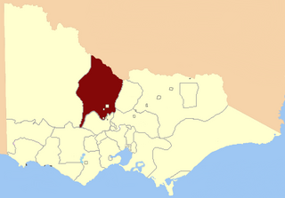
Avoca was an electoral district of the Legislative Assembly in the Australian state of Victoria from 1859 to 1889. It was based in northern Victoria. It was defined by the 1858 Electoral Act as:
Commencing at the source of the River Avoca in the Main Dividing Range ; thence northwards by that river and by a line bearing north to the River Murray ; thence by the River Murray to the River Loddon; thence south-wards by the River Loddon to McNeil's Creek; thence by McNeil's Creek to the Main Dividing Range; and thence westerly by the Main Dividing Range to the commencing point aforesaid, including the parish of Tarnagulla.
The Electoral district of Geelong was one of the original sixteen electoral districts of the old unicameral Victorian Legislative Council of 1851 to 1856. Victoria being a colony in Australia at the time.

The Electoral district of City of Melbourne was one of the original sixteen electoral districts of the old unicameral Victorian Legislative Council of 1851 to 1856; Victoria having been made a separate colony in Australia in the former year.

The Electoral district of North Bourke was one of the original sixteen electoral districts of the old unicameral Victorian Legislative Council of 1851 to 1856. Victoria being a colony in Australia at the time.

The Electoral district of Wimmera was one of the original sixteen electoral districts of the old unicameral Victorian Legislative Council of 1851 to 1856. Victoria being a colony in Australia at the time.
