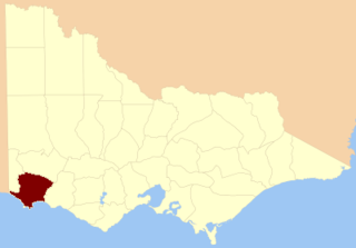
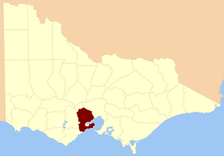
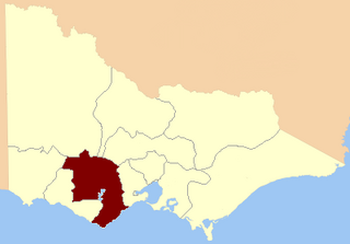
The Electoral district of Normanby was an electoral district in the Legislative Assembly of Victoria, it covered an area from the South Australian border to Portland Bay.

Members of the Victorian Legislative Council, the upper house of the Parliament of the Australian State of Victoria, are elected from eight multi-member electorates called regions. The Legislative Council has 40 members, five from each of the eight regions.

Western Province was an electorate of the Victorian Legislative Council (Australia), the upper house of the Parliament of Victoria. Victoria was a colony in Australia when Western Province was created. From Federation in 1901, Victoria was a state in the Commonwealth of Australia.

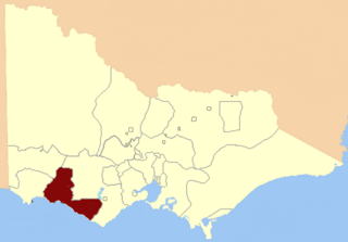
Dundas was an electoral district of the Legislative Assembly in the Australian state of Victoria from 1856 to 1976. It covered a region of western Victoria and consisted of the counties of Dundas and Follett.
Villiers and Heytesbury was an electoral district of the Legislative Assembly in the Australian state of Victoria from 1856 to 1904. It was based in western Victoria, and included the area from Lake Corangamite along the coast westward past Port Fairy.
North Grant was an electoral district of the Legislative Assembly in the Australian state of Victoria from 1856 to 1859. It was bordered on the north by the Werribee River and included the town of Buninyong. The district of North Grant was one of the initial districts of the first Victorian Legislative Assembly, 1856. North Grant was incorporated into the electoral district of Grenville in 1859.
North Grenville was an electoral district of the Legislative Assembly in the Australian state of Victoria from 1856 to 1859. It was bordered on the east by the Yarrowee River and included an area south of Ballarat. The short-lived, rural district of North Grenville was one of the initial districts of the first Victorian Legislative Assembly, 1856.

Polwarth, Ripon, Hampden and South Grenville was an electoral district of the Legislative Assembly in the Australian state of Victoria from 1856 to 1859. It was based in western Victoria.
South Grant was an electoral district of the Legislative Assembly in the Australian state of Victoria from 1856 to 1877.

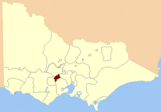
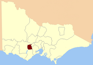
Grenville was an electoral district of the Legislative Assembly in the Australian state of Victoria from 1859 to 1927. It was located in western Victoria, south of Ballarat.

Polwarth and South Grenville was an electoral district of the Legislative Assembly in the Australian state of Victoria from 1859 to 1889. It was based in western Victoria.

Ripon and Hampden was an electoral district of the Legislative Assembly in the Australian state of Victoria from 1859 to 1904. It was based in western Victoria.
The Electoral district of Belfast and Warrnambool was one of the original sixteen electoral districts of the unicameral Legislative Council of the British colony of Victoria in 1851 to 1856.

The Electoral district of City of Melbourne was one of the original sixteen electoral districts of the old unicameral Victorian Legislative Council of 1851 to 1856; Victoria having been made a separate colony in Australia in the former year.

The Electoral district of Normanby, Dundas and Follett was one of the original sixteen electoral districts of the old unicameral Victorian Legislative Council of 1851 to 1856. Victoria being a colony on the continent of Australia at the time.
The Electoral district of Kilmore, Kyneton and Seymour was one of the original sixteen electoral districts of the old unicameral Victorian Legislative Council of 1851 to 1856. Victoria being a colony in Australia at the time.
The Electoral district of Ripon, Hampden, Grenville and Polwarth was one of the original sixteen electoral districts of the old unicameral Victorian Legislative Council of 1851 to 1856. Victoria being a colony in Australia at the time.

The Electoral district of Talbot, Dalhousie and Angelsey was one of the original sixteen electoral districts of the old unicameral Victorian Legislative Council of 1851 to 1856. Victoria being a colony in Australia at the time.

The Electoral district of Wimmera was one of the original sixteen electoral districts of the old unicameral Victorian Legislative Council of 1851 to 1856. Victoria being a colony in Australia at the time.
William Rutledge, also known as Billy Rutledge, was a politician in colonial Victoria (Australia), a member of the Victorian Legislative Council, and later, of the Victorian Legislative Assembly.
