Related Research Articles
A caldera is a large cauldron-like hollow that forms shortly after the emptying of a magma chamber in a volcano eruption. When large volumes of magma are erupted over a short time, structural support for the rock above the magma chamber is gone. The ground surface then collapses into the emptied or partially emptied magma chamber, leaving a large depression at the surface. Although sometimes described as a crater, the feature is actually a type of sinkhole, as it is formed through subsidence and collapse rather than an explosion or impact. Compared to the thousands of volcanic eruptions that occur each century, the formation of a caldera is a rare event, occurring only a few times per century. Only seven caldera-forming collapses are known to have occurred between 1911 and 2016. More recently, a caldera collapse occurred at Kīlauea, Hawaii in 2018.

Otto Wilhelm Hermann von Abich was a German mineralogist and geologist. Full member of St Petersburg Academy of Sciences.

Orogeny is a mountain-building process that takes place at a convergent plate margin when plate motion compresses the margin. An orogenic belt or orogen develops as the compressed plate crumples and is uplifted to form one or more mountain ranges. This involves a series of geological processes collectively called orogenesis. These include both structural deformation of existing continental crust and the creation of new continental crust through volcanism. Magma rising in the orogen carries less dense material upwards while leaving more dense material behind, resulting in compositional differentiation of Earth's lithosphere. A synorogenic process or event is one that occurs during an orogeny.
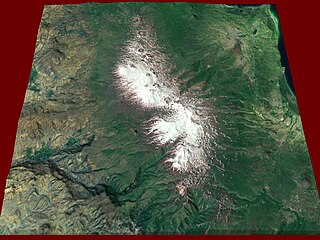
Tungurahua is an active stratovolcano located in the Cordillera Oriental of Ecuador. The volcano gives its name to the province of Tungurahua. Volcanic activity restarted on August 19, 1999, and is ongoing as of 2023, with several eruptive episodes since then, the most recent lasting from February 26 to March 16, 2016.

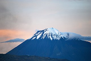
Cotopaxi is an active stratovolcano in the Andes Mountains, located near Latacunga city of Cotopaxi Province, about 50 km (31 mi) south of Quito, and 31 km (19 mi) northeast of the city of Latacunga, Ecuador. It is the second highest summit in Ecuador, reaching a height of 5,897 m (19,347 ft). Cotopaxi is among the highest active volcanoes in the world.

Mount Thielsen, or Big Cowhorn, is an extinct shield volcano in the Oregon High Cascades, near Mount Bailey. Because eruptive activity ceased 250,000 years ago, glaciers have heavily eroded the volcano's structure, creating precipitous slopes and a horn-like peak. The spire-like shape of Thielsen attracts lightning strikes and creates fulgurite, an unusual mineral. The prominent horn forms a centerpiece for the Mount Thielsen Wilderness, a reserve for recreational activities such as skiing and hiking. Thielson is one of Oregon's Matterhorns.
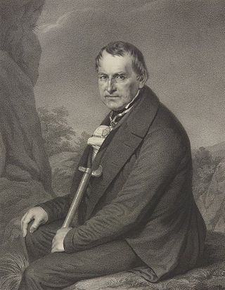
Christian Leopold von Buch, usually cited as Leopold von Buch, was a German geologist and paleontologist born in Stolpe an der Oder and is remembered as one of the most important contributors to geology in the first half of the nineteenth century. His scientific interest was devoted to a broad spectrum of geological topics: volcanism, petrology, fossils, stratigraphy and mountain formation. His most remembered accomplishment is the scientific definition of the Jurassic system.

Mount Katmai is a large active stratovolcano on the Alaska Peninsula in southern Alaska, located within Katmai National Park and Preserve. It is about 6.3 miles (10 km) in diameter with a central lake-filled caldera about two by three miles in size, formed during the Novarupta eruption of 1912. The caldera rim reaches a maximum elevation of 6,716 feet (2,047 m). In 1975 the surface of the crater lake was at an elevation of about 4,220 feet (1,286 m), and the estimated elevation of the caldera floor is about 3,400 ft (1,040 m). The mountain is located in Kodiak Island Borough, very close to its border with Lake and Peninsula Borough. The volcano has caused ten known fatalities due to gas exposure.
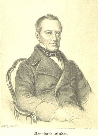
Prof Bernhard Studer HFRSE, was a 19th-century Swiss geologist.

A geosyncline is an obsolete geological concept to explain orogens, which was developed in the late 19th and early 20th centuries, before the theory of plate tectonics was envisaged. A geosyncline was described as a giant downward fold in the Earth's crust, with associated upward folds called geanticlines, that preceded the climax phase of orogenic deformation.

Hans Wilhelm Stille was an influential German geologist working primarily on tectonics and the collation of tectonic events during the Phanerozoic. Stille adhered to the contracting Earth hypothesis and together with Leopold Kober he worked on the geosyncline theory to explain orogeny. Stille's ideas emerged in the aftermath of Eduard Suess' book Das Antlitz der Erde (1883–1909). Stille's and Kober's school of thought was one of two that emerged in the post-Suess era the other being headed by Alfred Wegener and Émile Argand. This competing view rejected Earth contraction and argued for continental drift. As Stille opposed continental drift he came to be labelled a "fixist".
Before the concept of plate tectonics, global cooling was a geophysical theory by James Dwight Dana, also referred to as the contracting earth theory. It suggested that the Earth had been in a molten state, and features such as mountains formed as it cooled and shrank. As the interior of the Earth cooled and shrank, the rigid crust would have to shrink and crumple. The crumpling could produce features such as mountain ranges.

Ali Mehmet Celâl Şengör is a Turkish geologist. He is retired from the faculty at Istanbul Technical University, Department of Geological Engineering.
Gegham mountains are a range of mountains in Armenia. The range is a tableland-type watershed basin of Sevan Lake from east, inflows of rivers Araks and Hrazdan from north and west, Azat and Vedi rivers from south-west and Arpachai river from south. The average elevation of the Gegham mountain range is near 2500m. The range is of volcanic origin including many extinct volcanoes. The range is 70 km length and 48 km width, and stretch between Lake Sevan and the Ararat plain. The highest peak of the Gegham mountains is the Azhdahak, at 3597m. They are formed by a volcanic field, containing Pleistocene-to-Holocene lava domes and cinder cones. The highland reaches a height of 1800–2000m up to 3000m in the dividing ridge.

Cimmeria was an ancient continent, or, rather, a string of microcontinents or terranes, that rifted from Gondwana in the Southern Hemisphere and was accreted to Eurasia in the Northern Hemisphere. It consisted of parts of present-day Turkey, Iran, Afghanistan, Pakistan, Tibet, China, Myanmar, Thailand, and Malaysia. Cimmeria rifted from the Gondwanan shores of the Paleo-Tethys Ocean during the Early Permian and as the Neo-Tethys Ocean opened behind it, during the Permian, the Paleo-Tethys closed in front of it. Because the different chunks of Cimmeria drifted northward at different rates, a Meso-Tethys Ocean formed between the different fragments during the Cisuralian. Cimmeria rifted off Gondwana from east to west, from Australia to the eastern Mediterranean. It stretched across several latitudes and spanned a wide range of climatic zones.

Mount Iwaki is a stratovolcano located in western Aomori Prefecture, Tohoku, Japan. It is also referred to as Tsugaru Fuji (津軽富士) and less frequently, Okufuji (奥富士) due to its similar shape to Mount Fuji. With a summit elevation of 1,625 meters (5,331 ft) and a prominence of 1,322 meters (4,337 ft) it is the highest mountain in Aomori Prefecture.

Cosmos: A Sketch of a Physical Description of the Universe is an influential treatise on science and nature written by the German scientist and explorer Alexander von Humboldt. Cosmos began as a lecture series delivered by Humboldt at the University of Berlin, and was published in five volumes between 1845 and 1862. In the first volume of Cosmos, Humboldt paints a general "portrait of nature", describing the physical nature of outer space and the Earth. In the second volume he describes the history of science.
Johann Heinrich Conrad Gottfried Gustav Steinmann was a German geologist and paleontologist. He performed various studies in the Ural Mountains, North America, South America, the Caucasus and the Alps. Steinmann had a large number of scientific publications. He made contributions to the Theory of Evolution and to the study of the structural geology and orogeny of the Andes.
The Gustav-Steinmann-Medaille is a scientific award by the Deutsche Geologische Gesellschaft - Geologische Vereinigung to an individual who has made outstanding contributions in the fields of geology and earth sciences. The award is named after the German geologist and paleontologist Gustav Steinmann.
Réunion is a mafic island formed as a result of the Réunion hotspot in the Indian Ocean, the same hotspot that produced the massive basalt flows of the Deccan Traps, when it was beneath India more than 66 million years ago.
References
- 1 2 Şengör (1982), p. 4
- 1 2 3 Şengör (1982), p. 5
- 1 2 Seibold, Ilse; Seibold, Eugen (2006). "Hermann Wilhelm Abich im Kaukasus: Zum zweihundertsten Geburtstag". International Journal of Earth Sciences (in German). 95 (6): 1087–1100. doi:10.1007/s00531-006-0100-z. S2CID 129731016.
- ↑ Milanovsky, E.E. (2007). "Hermann Abich (1806 –1886): 'the Father of Caucasian Geology and his travels in the Caucasus and Armenian Highlands". In Jackson, Patrick N. Wyse (ed.). Four Centuries of Geological Travel: The Search for Knowledge on Foot, Bicycle, Sledge and Camel. Geological Society Special Publication. pp. 177–181.
- ↑ Şengör (1982), p. 6