
Nailsea is a town in Somerset, England, 8 miles (13 km) southwest of Bristol, and 11 miles (18 km) northeast of Weston-super-Mare. The nearest village is Backwell, which lies south of Nailsea on the opposite side of the Bristol to Exeter railway line. Nailsea had a population of 15,630 in the 2011 Census.
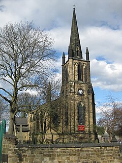
Elsecar is a village in the Metropolitan Borough of Barnsley in South Yorkshire, England. It is near the villages of Jump and Wentworth and 1.5 miles (2.4 km) south of the town of Hoyland, 6 miles (9.7 km) south of Barnsley and 8 miles (13 km) north-east of Sheffield. Elsecar falls within the Barnsley MBC Ward of Hoyland Milton. Like many villages in the area, it was for many years a colliery village until the widespread pit closures during the 1980s.

The Astley Green Colliery Museum is a museum run by the Red Rose Steam Society in Astley near Tyldesley in Greater Manchester, England. Before becoming a museum, the site was a working colliery that produced coal from 1912 to 1970; it is now protected as a Scheduled Monument. The museum occupies a 15-acre (6 ha) site by the Bridgewater Canal which has the only surviving pit headgear and engine house on the Lancashire Coalfield.
Coleford is a village and civil parish in Somerset, England, situated on the Mells River in the Mendip Hills five miles west of Frome. The parish has a population of 2,313 in 2011.

Wraxall is a village in North Somerset, England, about 6 miles (10 km) west of Bristol. Until 1811 the parish of the same name also included Nailsea and Flax Bourton. The village is now within the parish of Wraxall and Failand.
Big Pit National Coal Museum is an industrial heritage museum in Blaenavon, Torfaen, Wales. A working coal mine from 1880 to 1980, it was opened to the public in 1983 under the auspices of the National Museum of Wales. The site is dedicated to operational preservation of the Welsh heritage of coal mining, which took place during the Industrial Revolution.
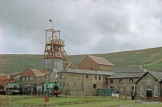
Haig Colliery Mining Museum was a visitor attraction in Kells, on the site of Cumbria's last deep coal mine on the cliffs above Whitehaven in Cumbria, England. It closed in January 2016 due to insolvency.

The National Coal Mining Museum for England is based at the site of Caphouse Colliery in Overton, Wakefield, West Yorkshire, England. It opened in 1988 as the Yorkshire Mining Museum and was granted national status in 1995.

Kilmersdon is a village and civil parish on the north eastern slopes of the Mendip Hills in Somerset between the towns of Radstock and Frome. It is located on the B3139 between Wells and Trowbridge in Wiltshire. The settlement is recorded in William I's Domesday book and dates back at least 1,000 years; though the core of the village dates from the mid nineteenth century. The parish includes the hamlets of Charlton, South View and Green Parlour.

Caphouse Colliery, originally known as Overton Colliery, was a coal mine in Overton, near Wakefield, West Yorkshire, England. It was situated on the Denby Grange estate owned by the Lister Kaye family, and was worked from the 18th century until 1985. It reopened as the Yorkshire Mining Museum in 1988, and is now the National Coal Mining Museum for England.

Netherton is a village in the City of Wakefield metropolitan borough of West Yorkshire, England. It lies about 4 miles south-west of Wakefield, 3 miles south of Ossett, 1 mile south of Horbury. The village is in the Wakefield Rural ward of Wakefield Metropolitan District Council. The village name is shown on map "Dvcatvs Eboracensis pars occidentalis" from 1646.
The Kent Coalfield was a coalfield in the eastern part of the English county of Kent. The Coalfields Trust defines the Kent Coalfield as the wards of Barham Downs and Marshside in the Canterbury district, and the wards of Aylesham, Eastry, Eythorne & Shepherdswell, Middle Deal & Sholden, Mill Hill and North Deal in the Dover district.

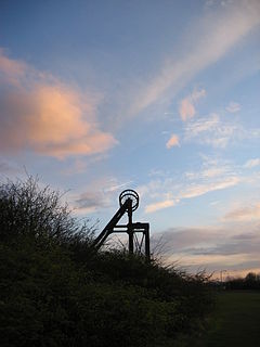
The Somerset Coalfield in northern Somerset, England is an area where coal was mined from the 15th century until 1973. It is part of a larger coalfield which stretched into southern Gloucestershire. The Somerset coalfield stretched from Cromhall in the north to the Mendip Hills in the south, and from Bath in the east to Nailsea in the west, a total area of about 240 square miles (622 km2). Most of the pits on the coalfield were concentrated in the Cam Brook, Wellow Brook and Nettlebridge Valleys and around Radstock and Farrington Gurney. The pits were grouped geographically, with clusters of pits close together working the same coal seams often under the same ownership. Many pits shared the trackways and tramways which connected them to the Somerset Coal Canal or railways for distribution.
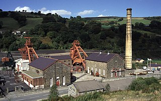
Rhondda Heritage Park, Trehafod, Rhondda, South Wales is a tourist attraction which offers an insight into the life of the coal mining community that existed in the area until the 1980s.
Prestongrange Museum is an industrial heritage museum at Prestongrange between Musselburgh and Prestonpans on the B1348 on the East Lothian coast, Scotland. Founded as the original site of the National Mining Museum, its operation reverted to East Lothian Council Museum Service in 1992.

Chatterley Whitfield Colliery is a disused coal mine on the outskirts of Chell, Staffordshire in Stoke on Trent, England. It was the largest mine working the North Staffordshire Coalfield and was the first colliery in the UK to produce one million tons of saleable coal in a year.

Great Western Mine, also known as Hetty Pit, was a coal mine, at Hopkinstown, near Pontypridd, Glamorgan in South Wales.

Nailsea Glassworks was a glass manufacturing factory in Nailsea in the English county of Somerset. The remaining structures have been designated as a scheduled monument.

The Brendon Hills are a range of hills in western Somerset, England. The hills merge level into the eastern side of Exmoor and are included within the Exmoor National Park. Iron ore and other minerals have been extracted for industrial purposes, primarily by the Brendon Hills Iron Ore Company in the later half of the 19th century.

