Elysian Fields, Mississippi

Last updated
Elysian Fields
USA Mississippi location map.svg
Red pog.svg
Elysian Fields
Coordinates: 31°05′21″N91°01′30″W / 31.08917°N 91.02500°W / 31.08917; -91.02500 Coordinates: 31°05′21″N91°01′30″W / 31.08917°N 91.02500°W / 31.08917; -91.02500
Country United States
State Mississippi
County Amite
Elevation
315 ft (96 m)
Time zone UTC-6 (Central (CST))
  Summer (DST) UTC-5 (CDT)
GNIS feature ID685256 [1]

Elysian Fields is a ghost town in Amite County, Mississippi, United States.

Established in the early 18th century, the settlement today is uninhabited and covered by forest.

History

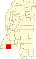
Elysian Fields was located approximately 2.5 mi (4.0 km) east of the present city of Centreville. The settlement began in 1718 as a rest station along a pioneer trail and pony mail route. [2] [3]

The Spanish established a trading post at Elysian Fields in 1781, and used the site until 1789 as a place where land grants were provided to settlers arriving from the eastern American states. After Spanish rule ended in 1798, Elysian Fields became the location of the Amite County courthouse, and the town was sometimes referred to as "Amite Courthouse". [4]

Settlers began to populate the town, and erected the New Providence Baptist Church in 1804, and the Midway Methodist Church in 1817. [3] An auxiliary branch of the American Bible Society was established in 1823, [5] and a post office was built in 1824. [6]

A gazetteer from 1838 described Amite County's "chief towns" as Liberty, Centreville and Elysian Fields. [7]

Elysian Fields relocated to Centreville in 1883 after the Yazoo and Mississippi Valley Railroad was constructed there. The former site of Elysian Fields, then called "Old Centreville", soon became extinct. [3] [4]

Related Research Articles

<span class="mw-page-title-main">Perry County, Missouri</span> County in Missouri, United States

Perry County is a county located in the southeastern portion of the U.S. state of Missouri. As of the 2020 census, the population was 18,956. Its county seat is Perryville. The county was officially organized on November 16, 1820 from Ste. Genevieve County and was named after Oliver Hazard Perry, a naval hero of the War of 1812.

<span class="mw-page-title-main">Yalobusha County, Mississippi</span> County in Mississippi, United States

Yalobusha County is a county located in the U.S. state of Mississippi. As of the 2020 census, the population was 12,481. It has two county seats, Water Valley and Coffeeville.

<span class="mw-page-title-main">Amite County, Mississippi</span> County in Mississippi, United States

Amite County is a county located in the state of Mississippi on its southern border with Louisiana. As of the 2020 census, the population was 12,720. Its county seat is Liberty. The county is named after the Amite River, which runs through the county.

<span class="mw-page-title-main">Amite City, Louisiana</span> Town in Louisiana, United States

Amite City is a town in and the seat of Tangipahoa Parish in southeastern Louisiana, United States. The population was 4,141 at the 2010 census. It is part of the Hammond Micropolitan Statistical Area.

<span class="mw-page-title-main">Liberty, Mississippi</span> Town in Mississippi, United States

Liberty is a town in Amite County, Mississippi. It is part of the McComb, Mississippi micropolitan statistical area. It is the county seat of Amite County.

<span class="mw-page-title-main">Ste. Genevieve, Missouri</span> City in Missouri, United States

Ste. Genevieve is a city in Ste. Genevieve Township and is the county seat of Ste. Genevieve County, Missouri, United States. The population was 4,999 at the 2020 census. Founded in 1735 by French Canadian colonists and settlers from east of the river, it was the first organized European settlement west of the Mississippi River in present-day Missouri. Today, it is home to Ste. Genevieve National Historical Park, the 422nd unit of the National Park Service.

<span class="mw-page-title-main">Centreville, Mississippi</span> Town in Mississippi, United States

Centreville is a town in Amite and Wilkinson counties, Mississippi, United States. It is part of the McComb, Mississippi micropolitan statistical area. Its population was 1,258 in 2020.

<span class="mw-page-title-main">St. Charles Parish, Louisiana</span> Parish in Louisiana, United States

St. Charles Parish is a parish located in the U.S. state of Louisiana. At the 2020 census, its population was 52,549. The parish seat is Hahnville and the most populous community is Luling.

<span class="mw-page-title-main">Arkansas Post</span> Historic site and museum in Arkansas County, Arkansas

The Arkansas Post, formally the Arkansas Post National Memorial, was the first European settlement in the Mississippi Alluvial Plain and present-day U.S. state of Arkansas. In 1686, Henri de Tonti established it on behalf of Louis XIV of France for the purpose of trading with the Quapaw Nation. The French, Spanish, and Americans, who acquired the territory in 1803 with the Louisiana Purchase, considered the site of strategic value. It was the capital of Arkansas from 1819 until 1821 when the territorial government relocated to Little Rock.

<span class="mw-page-title-main">St. Stephens, Alabama</span> CDP in Alabama, United States

St. Stephens is an unincorporated census-designated place in Washington County, Alabama, United States. Its population is 580. Located near the Tombigbee River in the southwestern part of the state and 67 miles north of Mobile, it is composed of two distinct sites: Old St. Stephens and New St. Stephens. The Old St. Stephens site lies directly on the river and is no longer inhabited. It was the territorial capital of the Alabama Territory. Now encompassed by the Old St. Stephens Historical Park, it is listed on the National Register of Historic Places.

<span class="mw-page-title-main">Mississippi-in-Africa</span> Private colony in present-day Liberia

Mississippi-in-Africa was a colony on the Pepper Coast founded in the 1830s by the Mississippi Colonization Society of the United States and settled by American free people of color, many of them former slaves. In the late 1840s, some 300 former slaves from Prospect Hill Plantation and other Isaac Ross properties in Jefferson County, Mississippi, were the largest single group of emigrants to the new colony. Ross had freed the slaves in his will and provided for his plantation to be sold to pay for their transportation and initial costs.

<span class="mw-page-title-main">Mississippi Highway 48</span> Highway in Mississippi

Mississippi Highway 48 is a state highway in southern Mississippi. It runs from east to west for 83.6 miles (134.5 km), serving a total of four counties: Marion, Walthall, Pike, and Amite.

The history of Pensacola, Florida, begins long before the Spanish claimed founding of the modern city in 1698. The area around present-day Pensacola was inhabited by Native American peoples thousands of years before the historical era.

<span class="mw-page-title-main">Warrenton, Mississippi</span> Unincorporated community in Mississippi, United States

Warrenton is an unincorporated community in Warren County, Mississippi. It is located approximately 5 miles south of Vicksburg on U.S. Route 61.

<span class="mw-page-title-main">W.S. Hull</span> American architect

William S. Hull (1848-1924) was an architect based in Jackson, Mississippi who designed over twenty county courthouses in the American South.

<span class="mw-page-title-main">Colonial history of Missouri</span>

The Colonial history of Missouri covers the French and Spanish exploration and colonization: 1673–1803, and ends with the American takeover through the Louisiana Purchase

Gainesville is a ghost town located in Hancock County, Mississippi.

Bewelcome is an unincorporated community in Amite County, Mississippi, United States.

<span class="mw-page-title-main">Galveztown, Louisiana</span> Ghost town in Louisiana, United States

Galveztown, or Villa de Gálvez, is a ghost town located at the confluence of Bayou Manchac and the Amite River in Ascension Parish, Louisiana. Galveztown was established in 1778 with the settlement of Canary Islanders colonists and Anglo-Americans fleeing the American Revolutionary War. Due to deplorable conditions and disease, the settlement was eventually abandoned and many residents fled to Spanish Town in 1806. Some former residents remained in the area and established the community of Gálvez, Louisiana during the first half of the nineteenth century.

References

  1. U.S. Geological Survey Geographic Names Information System: Elysian Fields (historical)
  2. "State of Mississippi, House Concurrent Resolution No. 225". Southern Herald. September 21, 1989.
  3. 1 2 3 "Wilkinson County - A Brief History of its Communities". Woodville Republican. March 23, 1973.
  4. 1 2 "Two Hundred Birthday Celebration". Southern Herald. July 13, 1989.
  5. Annual Report of the American Bible Society, Volumes 6-10. American Bible Society. 1822. p. 20.
  6. "Centreville Historic District". National Park Service. July 28, 1992.
  7. Basacon's Annual Register. Basacon. 1838. pp.  123.