
Mount Auburn is a village in Christian County, Illinois, United States. The population was 452 at the 2020 census.

Mount Vernon is a city in and the county seat of Jefferson County, Illinois, United States. The population was 14,600 at the 2020 census. Mount Vernon is the principal city of the Mount Vernon Micropolitan Statistical Area, which includes all of Jefferson and Hamilton counties.

Mount Jackson is a town in Shenandoah County, Virginia, United States. The population was 1,994 at the 2010 census.

Mount Washington, in New Hampshire, is the highest peak in the Northeastern United States at 6,288.2 ft (1,916.6 m) and the most topographically prominent mountain east of the Mississippi River.

Allegany State Park is a state park in western New York State, located in Cattaraugus County just north of the Allegheny National Forest in Pennsylvania. The park is divided into two sections: The Red House Area and the Quaker Run Area. It lies within the Allegheny Highlands forests ecoregion.
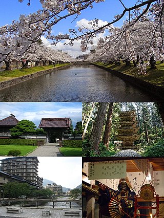
Tsuruoka is a city in Yamagata Prefecture, Japan. As of 31 January 2020, the city had an estimated population of 125,389 in 49,024 households, and a population density of 95.74 persons per km². The total area of the city is 1,311.53 square kilometres. Tsuruoka is the biggest city in Tōhoku region in terms of surface area.

Mount Kailash, is a mountain in the Ngari Prefecture, Tibet Autonomous Region of China. It has an altitude of 6,714 m (22,028 ft). It lies in the Kailash Range of the Transhimalaya, in the western part of the Tibetan Plateau. Mount Kailash is less than 100 km towards the north from the western trijunction of the borders of China, India, and Nepal.

Mount Eden is a suburb in Auckland, New Zealand whose name honours George Eden, 1st Earl of Auckland. It is 4 kilometres (2.5 mi) south of the Central Business District (CBD). Mt Eden Road winds its way around the side of Mount Eden Domain and continues to weave back and forth as it descends into the valley; it runs south from Eden Terrace to Three Kings. Mt Eden village centre is located roughly between Valley Road and Grange Road. The domain is accessible on foot from many of the surrounding streets, and by vehicle from Mt Eden Road. The central focus of the suburb is Maungawhau / Mount Eden, a dormant volcano whose summit is the highest natural point on the Auckland isthmus.
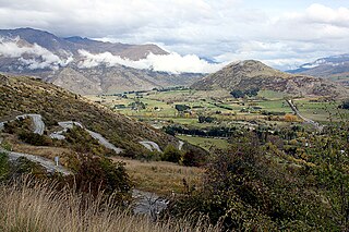
The Crown Range is a mountain range that lies to the east of the Wakatipu Basin in Otago, New Zealand. It is noted for two features, the Cardrona Alpine Resort, on the slopes of the 1900 metre Mount Cardrona, and a highway, known as the Crown Range Road, which winds steeply between Arrow Junction, just south of Arrowtown, and Wānaka to the north.

Mount Albert is an inner suburb of Auckland, New Zealand, which is centred on Ōwairaka / Mount Albert, a local volcanic peak which dominates the landscape. In the past Mt Albert also referred to the 2,500 acre borough that was created in 1911 on the outskirts of Auckland City. Mt Albert was also one of the original five wards within the Mt Albert Borough. The suburb is located seven kilometres to the southwest of the Central Business District (CBD).

Mount San Antonio, commonly referred to as Mount Baldy or Old Baldy, is a 10,064 ft (3,068 m) summit in the San Gabriel Mountains on the border of Los Angeles and San Bernardino counties of California. Lying within the San Gabriel Mountains National Monument and Angeles National Forest, it is the high point of the range, the County of Los Angeles, and the Los Angeles metropolitan area.
Auburn is an unincorporated community in Wake County, North Carolina, United States, just southeast of Raleigh. It lies approximately halfway between Garner and Clayton along Garner Road, a former alignment of US 70. The borders of the community are not well defined, but it is centered along Garner Road between Auburn Church Road and Guy Road.
The Spiritual Baptist faith is a religion created by persons of African ancestry in the plantations they came to in the former British West Indies countries predominantly in the islands of a Grenada, Saint Vincent and the Grenadines, Tobago and the Virgin Islands. It is syncretic Afro-Caribbean religion that combines elements of the many varied traditional African religions brought by the enslaved populations combined with Christianity. Spiritual Baptists consider themselves to be Christians.
Sandringham is a suburb of Auckland, New Zealand. It is a multi-ethnic suburb with a population of over 12,000.

State Route 24 is a primary state highway in the U.S. state of Virginia. The state highway runs 89.57 miles (144.15 km) from U.S. Route 221 and SR 116 in Roanoke east to US 60 in Mt. Rush. SR 24 connects Roanoke with several small communities in southern Bedford County and central Campbell County. The state highway also runs concurrently with US 460 west of Appomattox and passes through Appomattox Court House National Historical Park, which is the site of Robert E. Lee's final stand and surrender in the American Civil War.
Mt Lyford (1590m) is the home of an alpine village and ski resort in the South Island of New Zealand. It is 146 kilometres by road north of Christchurch on the Inland Kaikōura Road (SH70) between Culverden and Kaikoura. The resort is a 40-minute drive to Hanmer Springs and a 45-minute drive to Kaikoura. The nearby township of Waiau, Canterbury has a small supermarket, DIY store and petrol station. The Inland Kaikōura Road is very scenic and windy from Waiau through to Kaikōura and forms part of the Alpine Pacific Touring Route.

Mount Wilson is a village located in the Blue Mountains region of New South Wales, Australia. The village is about 14 kilometres (8.7 mi) east of the township of Bell, and about 100 kilometres (62 mi) west of Sydney. At the 2021 census, the village of Mount Wilson had a population of 81 people.
Hong Kong's Peak District was original named the "Hill District". It included Mount Austin, Mount Gough, Mount Kellett and the area around Magazine Gap. Many homes were for summer use only, to escape the heat of Central, and were referred to as "bungalows". Over time, they were given names, especially when the bungalows were rebuilt in brick or stone as substantial mansions, allowing them to better withstand the damage from typhoons.

Mount Rose is an unincorporated community located within Hopewell Township, in Mercer County, New Jersey, United States, situated at the corner of Carter Road, Pennington-Rocky Hill Road, and Cherry Valley Road. It is named for a local gardener. The Mount Rose section of Rocky Hill Ridge through the community also takes its name from the gardener. Richard Stout opened the first general store in the village around 1822 and in 1830, Josiah Cook and Reuben Savidge opened a second store. The settlement was also later home to two shoe shops, a dressmaker, wheelwrights, a blacksmith, a harness shop, an agricultural implements warehouse, a post office and a steam sawmill. In its heyday the community had about 20 houses. Nathaniel Drake opened an applejack distillery in the village in the mid-19th century. He made and sold peach brandy, apple cider and apple whiskey. The Whiskey House, the office building for the distillery and the only remaining Drake building in the village, is listed on the township, state and national registers of historic places. The community's schoolhouse, a stone building east of the crossroads, was later replaced by a frame building on the southern end of the village that is a private residence today. After 1880, Mount Rose began shrinking, due to the growth of nearby Hopewell. It is planned that the Lawrence Hopewell Trail will go through the community.
Ferncroft is an unincorporated community lying mostly in the town of Albany in Carroll County, New Hampshire, United States. Some of the roads and houses in Ferncroft stretch into the towns of Sandwich and Waterville Valley. The hamlet is a widely spaced cluster of houses centered on several fields lying along the Wonalancet River on Ferncroft Road.


