Encino Hot Springs

Last updated
Encino Hot Springs
El Encino Springs
El Encino Springs collection pond in 1901.png
El Encino Springs reservoir in 1901
Encino Hot Springs
Coordinates 34°9′32″N118°29′56″W / 34.15889°N 118.49889°W / 34.15889; -118.49889 NOAA
Type geothermal
Discharge65 liters/minute [1]
Temperature79–90 °F (26–32 °C)
Old bathhouse at Encino hot mineral spring, shown with Alex Abel, caretaker of the Amestoy Ranch Encino Spring old bathhouse, prior to 1920.png
Old bathhouse at Encino hot mineral spring, shown with Alex Abel, caretaker of the Amestoy Ranch

Encino Hot Springs are historic thermal springs located at the site of Siutcanga village, a settlement of the Tongva-Kizh people of the area now known as Southern California. It was used by several tribes of Indigenous peoples for thousands of years. Later, after settlement, the artesian springs were used as a water source for Rancho Los Encinos in what is now the San Fernando Valley region of Los Angeles County, California. In the 1880s it was a rest stop on the Butterfield Stagecoach route. The springs are located in the modern-day Los Encinos State Historic Park.

Contents

History

Rancho El Encino mapped in 1871, before the spring water reservoirs were constructed, showing groves of encinos (oaks), guatamotes (willows), and the overland stage road Rancho El Encino 1871.jpg
Rancho El Encino mapped in 1871, before the spring water reservoirs were constructed, showing groves of encinos (oaks), guatamotes (willows), and the overland stage road

In August 1769, an expedition led by Gaspar de Portola came upon a grove of oak trees (Spanish: encinos) which they named El Valle de la Catalina de Bononia de los Encinos. Franciscan missionary and explorer Juan Crespí, who was the diarist for the expedition, mentioned the artesian springs in his 1769 diary. He described the Indigenous peoples living there in two villages populated with a total of about 200 inhabitants. The springs were a gathering place for several thousand years for the Tongva, Chumash, Tataviam and other Indigenous tribes. [2] These Indigenous inhabitants were formerly referred to as "Fernandeños" by the Spanish colonialists because they were enslaved by the San Fernando Mission. [3] Rancho Los Encinos, the land encompassing the springs, was originally granted by the Spanish king to a veteran of the Portolá expedition named Juan Francisco Reyes, then regranted to the San Fernando Mission in 1797, and then finally, after secularization, in 1845, one square Spanish league was granted by the Mexican government to Ramon, Francisco and Roque, who are traditionally believed to have been Mission Indians. [4] Before the Battle of Providencia occurred in 1845, Manuel Micheltorena's troops camped at the Encino Springs. [5]

Description

From 1849 to 1862, Jose Vicente de los Reyes de la Ossa, commonly known as Vicente de la Osa, and his wife, Rita de la Osa, owned the historic rancho property where the springs were situated. Land case records state that de la Osa had sought out the "Native Americans who owned Encino prior to him in exchange for the right to purchase the rancho from them." [2] Another account states that de la Osa purchased the site from "three Indians" for $100. [6] De la Osa claimed that the springs on the property were "both cold and warm, the latter possessing medicinal qualities." [2] In the 1850s, De la Osa fenced off the springs and announced his intention to charge drovers two cents a head to water cattle and horses, and one cent per sheep. [7]

The spring water collection ponds were built around 1872 by Eugene Garnier, [8] and in 1875 it was reported that the main ranch spring "supplied a stone reservoir and a bathing pool and yielded about 5 U.S. gallons (19 L; 4.2 imp gal) a minute". [9] In 1890, an account of the springs described "a number" of sources that were in "local use" at Encino. [10]

"The Encino spring was used as one of the first mineral springs along El Camino Real. The old bathhouse was a favorite stop for riders along the Butterfield Stage route in the 1880s. They could refresh themselves from the long dusty trip from Los Angeles to San Francisco. The bathhouse fell into disrepair as shown here with Alex Abel, caretaker of the ranch under the Amestoys, and was later removed." [2]

In 1915, two spring sources were identified on the site, approximately 30 feet (9.1 m) apart within the stone reservoir, the smaller spring west of the larger spring. The geologic source of the water is associated with the Miocene shale, where the shale "dips about 25°N" toward the Valley, and was a "primary and secondary alkaline and primary saline water of moderate mineralization". [9]

In 1925, a Mexican worker at the site discovered a 20-inch (51 cm) grinding mortar made of volcanic basalt, and a possible burial ground west of the springs. The large bowl-shaped mortar had a beaded edge. The Los Angeles Times reported that the archeologist John A. Comstock claimed the "Indians in the Encino Hot Springs vicinity fashioned the finest stone vessels of any Indians In this part of the country with the possible exception of Catalina Island Indians, who had a stone particularly adaptable to such purposes". The mortero was estimated to be between 1000 and 1500 years old. [11]

In 1946 it was reported that the state of California had established a fund to acquire El Ranchos de Los Encinos, (a five-acre rancho), including the hot springs that formerly belonged to the Indigenous peoples of the area. [6]

In 1949, the National Environmental Health Association published a study on mosquitos in the Los Angeles area, stating that two species that may carry disease had been found in the hot springs area. [12] The springs have been under the purview of the California State Parks and Recreation department since 1949, [13] and continue to feed the reservoir (alternately called an artificial lake or "fishpond") that was built by Garnier in the 1870s. [3] [14]

Historic resort

"Encino Hot Springs" Los Angeles Evening Express, September 22, 1923 "Encino Hot Springs" Los Angeles Evening Express, September 22, 1923.jpg
"Encino Hot Springs" Los Angeles Evening Express, September 22, 1923

In the 1920s, a resort and hotel operated at Encino Hot Springs. [15] [16] [17] The resort was built on Ventura Boulevard, and became a popular spot that included entertainment. In July 1922, the Van Nuys News reported that over 1000 people visited the resort in one day. The report stated that the site was known as the "old Amestoy Homestead", and mentioned that a swimming pool and dance hall were being constructed at the "famous hot spring". [18]

In 1928, the hot springs property was purchased from T.S. Ward and Mrs. R. White by H.W. Oakes, a restaurant owner from San Diego. [19]

Water profile

In 1875, the hot spring water temperature was measured at 85 °F (29 °C). The mineral content was recorded as including sodium, calcium, sulphate, chloride, carbonate, silica, and trace amounts of potassium, lithium and phosphate. Carbon dioxide and hydrogen sulphide gasses percolated up through the spring water. [9]

Decades later, NOAA measured the spring water temperature at 79 °F (26 °C) at the source. [20]

In 1969, the measured yield of the springs was 24,000 U.S. gallons (91,000 L; 20,000 imp gal) per day. [21] The hot springs continue to flow, as of 1978, at the Los Encinos State Historic Park. [22]

See also

Related Research Articles

<span class="mw-page-title-main">Canoga Park, Los Angeles</span> Neighborhood of Los Angeles

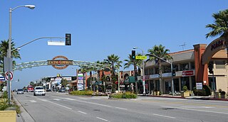
Canoga Park is a neighborhood in the San Fernando Valley region of the City of Los Angeles, California. Before the Mexican–American War, the district was part of a rancho, and after the American victory it was converted into wheat farms and then subdivided, with part of it named Owensmouth as a town founded in 1912. It joined Los Angeles in 1917 and was renamed Canoga Park on March 1, 1931, after Canoga, New York.

<span class="mw-page-title-main">San Fernando Valley</span> Valley in Los Angeles County, California, US

The San Fernando Valley, known locally as the Valley, is an urbanized valley in Los Angeles County, California. Situated to the north of the Los Angeles Basin, it contains a large portion of the city of Los Angeles, as well as several unincorporated areas; and the incorporated cities of Burbank, Calabasas, Glendale, Hidden Hills, and San Fernando. The valley is well known for its film studios such as Warner Bros. Studios and Walt Disney Studios. In addition, it is home to the Universal Studios Hollywood theme park.

<span class="mw-page-title-main">Chatsworth, Los Angeles</span> Neighborhood of Los Angeles in California, United States

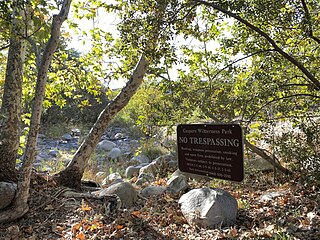
Chatsworth is a suburban neighborhood in Los Angeles, California, in the San Fernando Valley.

<span class="mw-page-title-main">Encino, Los Angeles</span> Neighborhood of Los Angeles in California, United States

Encino is a neighborhood in the San Fernando Valley region of Los Angeles, California.

<span class="mw-page-title-main">Ventura Boulevard</span> Thoroughfare in San Fernando Valley

Ventura Boulevard is one of the primary east–west thoroughfares in the San Fernando Valley region of the City of Los Angeles, California. Ventura Boulevard is one of the oldest routes in the San Fernando Valley as it is along the commemorative route El Camino Real. It was also U.S. Route 101 (US 101) before the freeway was built, and it was also previously signed as U.S. Route 101 Business.

<span class="mw-page-title-main">Domingo Amestoy</span> Basque sheepherder and banker

Domingo Amestoy —born Dominique— (1822–1892) was a Basque sheepherder, and banker, one of the original founders to provide the financing for the Farmers and Merchants Bank in Los Angeles, California, in 1871.

<span class="mw-page-title-main">Whittier Narrows</span>

The Whittier Narrows is a narrows or water gap in the San Gabriel Valley of Los Angeles County, California, United States, between the Puente Hills to the east and the Montebello Hills to the west. The gap is located at the southern boundary of the San Gabriel Valley, through which the Rio Hondo and the San Gabriel River flow to enter the Los Angeles Basin. The Narrows is located near the convergence of Interstate 605 and California State Route 60.

<span class="mw-page-title-main">Campo de Cahuenga</span> Historic house in California, United States

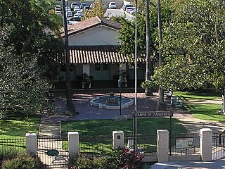
The Campo de Cahuenga, near the historic Cahuenga Pass in present-day Studio City, California, was an adobe ranch house on the Rancho Cahuenga where the Treaty of Cahuenga was signed between Lieutenant Colonel John C. Frémont and General Andrés Pico in 1847, ending hostilities in California between Mexico and the United States. The subsequent Treaty of Guadalupe Hidalgo of 1848, ceding California, parts of Colorado, Nevada, New Mexico, and Arizona to the United States, formally ended the Mexican–American War. From 1858 to 1861 the Campo de Cahuenga became a Butterfield Stage Station.

<span class="mw-page-title-main">Eulalia Pérez de Guillén Mariné</span> Mexican-American mayor doma (d. 1878)

Eulalia Pérez de Guillén Mariné was a Californio who was mayordoma of Mission San Gabriel Arcángel and grantee of Rancho del Rincón de San Pascual in the San Rafael Hills, in present-day Los Angeles County, California. She claimed to have been born in 1766, if so making her 112 years old at the time of her death in 1878, but her case has not been verified or fully proven.

<span class="mw-page-title-main">Puvunga</span> Indigenous sacred site in Long Beach, California, US

Puvunga is an ancient village and sacred site of the Tongva nation, the Indigenous people of the Los Angeles Basin, and the Acjachemen, the Indigenous people of Orange County. The site is now located within California State University, Long Beach and the surrounding area. The Tongva know Puvunga as the "place of emergence" and it is where they believed "their world and their lives began." Puvunga is an important ceremonial site and is the end to an annual pilgrimage for the Tongva, Acjachemen, and Chumash.

<span class="mw-page-title-main">Tongva Sacred Springs</span> Historic site in University High School, Los Angeles

The Tongva Sacred Springs are a group of springs located on the campus of University High School in Los Angeles, California. The springs, called Koruuvanga by the native Gabrieleno Tongva people, were used as a source of natural fresh water by the Tongva people since at least the 5th century BC and continue to produce 22,000–25,000 US gallons (83,000–95,000 L) of water a day. The springs are also sometimes referred to as the Gabrieleno-Tongva Springs, the Tongva Holy Springs, and the Sacred Springs.

<span class="mw-page-title-main">Rancho Los Encinos</span> Historic land grant rancho in San Fernando Valley, California

Rancho Los Encinos was a Spanish grazing concession, and later Mexican land granted cattle and sheep rancho and travelers way-station on the El Camino Real in the San Fernando Valley, in present-day Encino, Los Angeles County, California. The original 19th-century adobe and limestone structures and natural Encino Springs are now within the Los Encinos State Historic Park.

<span class="mw-page-title-main">Los Encinos State Historic Park</span> State park in Los Angeles County

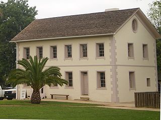
Los Encinos State Historic Park is a state park unit of California, preserving buildings of Rancho Los Encinos. The park is located near the corner of Balboa and Ventura Boulevards in Encino, California, in the San Fernando Valley. The rancho includes the original nine-room de la Ossa Adobe, the two-story limestone Garnier building, a blacksmith shop, a natural spring, and a pond. The 4.7-acre (1.9 ha) site was established as a California state park in 1949.

The history of the San Fernando Valley from its exploration by the 1769 Portola expedition to the annexation of much of it by the City of Los Angeles in 1915 is a story of booms and busts, as cattle ranching, sheep ranching, large-scale wheat farming, and fruit orchards flourished and faded. Throughout its history, settlement in the San Fernando Valley was shaped by availability of reliable water supplies and by proximity to the major transportation routes through the surrounding mountains.

<span class="mw-page-title-main">Cahuenga, California</span> Human settlement in California, United States

Cahuenga ( or "place of the hill" is a former Tongva–Tataviam Native American settlement in the San Fernando Valley of Los Angeles, Los Angeles County, California. One source suggests kawe means mountain in Tongva language. Recent linguistic work suggests an alternative meaning of "place of the fox". The Tongva-language suffix -nga indicates place, and the suffix -bet or -bit indicates person from place; people from Cahuenga were recorded in mission registers as Capuebet.

<span class="mw-page-title-main">Seminole Hot Springs, California</span> Unincorporated community in California, United States

Seminole Hot Springs is an unincorporated community in Los Angeles County, California, United States. Seminole Hot Springs is located in the Santa Monica Mountains near Cornell, 3.6 miles (5.8 km) south-southeast of Agoura Hills at an elevation of 932 feet (284 m).

<span class="mw-page-title-main">Guachama Rancheria</span> Historic site in Loma Linda, California

Kaawchama, alternatively referred to as Wa’aachnga, was a significant Tongva village in the San Bernardino Valley located in what is now west Redlands, California. The village became referred to by the Spanish as the Guachama Rancheria in 1810 after a supply station was constructed at the village for Mission San Gabriel, which then became part of Rancho San Bernardino following the secularization of the missions in 1833.

<span class="mw-page-title-main">Siutcanga</span>

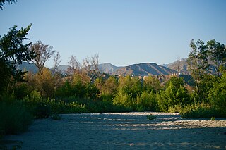
Siutcanga, alternatively spelled Syútkanga, was a Tataviam and Tongva village that was located in what is now Los Encinos State Historic Park near the site of a natural spring. The traditional trading route which the village relied on to flourish is now the street known as Ventura Boulevard. The Fernandeño Tataviam Band of Mission Indians organization has indicated that the majority of their members descend from the village and maintain a deep relationship to the site. People of the village are known as Siutcavitam.

<span class="mw-page-title-main">Vicente de la Osa</span> Californio landowner (1808–1861)

Vicente de la Osa, baptized Jose Vicente de los Reyes de la Ossa, was a Californio city official, tavern owner, and cattle rancher who owned Rancho Providencia and Rancho Los Encinos in what is now the San Fernando Valley area of Southern California in the United States.

References

  1. Higgins, Chris T.; Therberge, Albert E. Jr.; Ikelman, Joy A. (1980). Geothermal Resources of California (PDF) (Map). NOAA National Geophysical Center. Sacramento: California Department of Mines and Geology.
  2. 1 2 3 4 Crosby, Michael (2009-06-08). Encino. Arcadia Publishing. ISBN   978-1-4396-2316-9.
  3. 1 2 "Los Encinos State Historic Park". CA.gov. California Department of Parks and Recreation. Retrieved 12 November 2023.
  4. "Ranchos of California; a list of Spanish concessions, 1775-1822, and Mexican grants, 1822-1846". HathiTrust. p. 34. hdl:2027/uc1.32106008754035 . Retrieved 2023-11-12.
  5. Harris, Scott (1996-09-24). "HISTORY: The Battle That May Have Saved the Nation". The Los Angeles Times. p. 30. Retrieved 2023-11-01.
  6. 1 2 Price, Gertrude (28 May 1946). "Makes bid for public assistance in preserving historic Encino". Daily News (Los Angeles).
  7. "Brief History of Vincente de la Osa and Family" (PDF). historicparks.org. Retrieved 2023-11-12.
  8. "Amestoy Rancho Historic Landmark". Valley Times. 1950-07-28. p. 9. Retrieved 2023-11-01.
  9. 1 2 3 Waring, Gerald Ashley (January 1915). Springs of California. Water-Supply Paper no. 338–339 (Department of the Interior, United States Geological Survey Water-Supply Papers). Washington, D.C.: U.S. Government Printing Office. pp. 246–247. Retrieved 2023-11-01 via HathiTrust.
  10. Anderson, Winslow (1890). Mineral Springs and Health Resorts of California: With a Complete Chemical Analysis of Every Important Mineral Water in the World. Bancroft Company. p. 194.
  11. "Burial Ground Indicated: Encino Hot Springs Scene of Discovery". The Los Angeles Times. 1925-11-03. p. 25. Retrieved 2023-11-11.
  12. Pierce, W. Dwight; Duclus, W.E.; Longacre, M.Y. (May 1945). "Mosquitoes of Los Angeles and Vicinity". The Sanitarian; National Environmental Health Association. 7 (6): 724. JSTOR   26323900 . Retrieved 11 November 2023.
  13. "Los Encinos State Historic Park History". los-encinos.org. Retrieved 2023-11-17.
  14. Berkstresser, C. F. (1968). Data for Springs in the Southern Coast, Transverse, and Peninsular Ranges of California. U.S. Department of the Interior, Geological Survey, Water Resources Division. pp. A-6.
  15. "Many Inspect Features of Encino Hot Springs Resort". The Van Nuys News and Valley Green Sheet. 1922-08-11. p. 1. Retrieved 2023-11-01.
  16. "He Says Jersey Giants Best Fryers". The Los Angeles Times. 1928-03-04. p. 143. Retrieved 2023-11-01.
  17. "He says Jersey Giants best fryers". Los Angeles Times. 4 March 1928. Retrieved 11 November 2023.
  18. "Encino Hot Springs Proving Popular Resort". Van Nuys News. 25 July 1922. Retrieved 12 November 2023.
  19. "San Diego Man is New Owner of Encino Springs". Van Nuys News. 31 January 1928. Retrieved 12 November 2023.
  20. "Thermal Springs in the U.S." NOAA National Centers for Environmental Information. Retrieved 11 November 2023.
  21. "The Los Angeles Times 03 Aug 1969, page 207". Newspapers.com. Retrieved 2023-11-01.
  22. Recreation, California Department of Parks and (1978). Los Encinos State Historic Park: Resource Management Plan. State of California, Resources Agency, Department of Parks and Recreation. p. 178.