
Adullam is an ancient ruin once numbered among the thirty-six cities of Canaan whose kings "Joshua and the children of Israel smote" (Joshua 12:7–24). After that, it fell as an inheritance to the tribe of Judah and was included in the northern division of the Shephelah "lowland" cities of the land of Judah (Joshua 15:35).
According to the Hebrew Bible, the Tribe of Ephraim was one of the tribes of Israel. The Tribe of Manasseh together with Ephraim formed the House of Joseph. It is one of the ten lost tribes. The etymology of the name is disputed.

Shunem or Shunaam was a small village mentioned in the Bible in the possession of the Tribe of Issachar. It was located near the Jezreel Valley, north of Mount Gilboa.

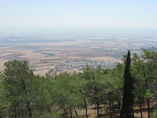
Givat HaMoreh is a hill in northern Israel on the northeast side of the Jezreel Valley. The highest peak reaches an altitude of 515 metres (1,690 ft), while the bottom of the Jezreel Valley is situated at an altitude of 50–100 metres (160–330 ft). North of it are the plains of the Lower Galilee and Mount Tabor. To the east, Giv'at HaMoreh connects to the Issachar Plateau. To the southeast it descends into the Harod Valley, where the 'Ain Jalut flows eastwards into the Jordan Valley.

Cana of Galilee is the location of the Wedding at Cana, at which the miracle of turning water into wine took place in the Gospel of John.

Gilgal, also known as Galgala or Galgalatokai of the 12 Stones, is the name of one or more places in the Hebrew Bible. Gilgal is mentioned 39 times, in particular in the Book of Joshua, as the place where the Israelites camped after crossing the Jordan River. The Hebrew term Gilgal most likely means "circle of stones". Its name appears in Koine Greek on the Madaba Map.

Tel Megiddo is the site of the ancient city of Megiddo, the remains of which form a tell or archaeological mound, situated in northern Israel at the western edge of the Jezreel Valley about 30 kilometres (19 mi) southeast of Haifa near the depopulated Palestinian town of Lajjun and subsequently Kibbutz Megiddo. Megiddo is known for its historical, geographical, and theological importance, especially under its Greek name Armageddon. During the Bronze Age, Megiddo was an important Canaanite city-state. During the Iron Age, it was a royal city in the Kingdom of Israel.
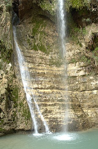
Ein Gedi, also spelled En Gedi, meaning "spring of the kid", is an oasis, an archeological site and a nature reserve in Israel, located west of the Dead Sea, near Masada and the Qumran Caves. Ein Gedi, a kibbutz, was established nearby in 1954.

Hamaam, or Wadi Hamam, is an Arab village in northern Israel, located near the Sea of Galilee, at the foot of Mount Nitai and across the Wadi Hamam valley from Mount Arbel. It is the easternmost part of the al-Batuf Regional Council. In 2022 its population was 1,561.
Meroz is a city mentioned in the Book of Judges.

Mount Tabor, sometimes spelled Mount Thabor, is a large hill of biblical significance in Lower Galilee, northern Israel, at the eastern end of the Jezreel Valley, 18 kilometres west of the Sea of Galilee.
Ein Harod (Ihud) (Hebrew: עֵין חֲרוֹד אִחוּד) is a kibbutz in northern Israel. Located in the Jezreel Valley near Mount Gilboa, it falls under the jurisdiction of Gilboa Regional Council. In 2022 it had a population of 537.

Indur was a Palestinian village, located 10.5 kilometres (6.5 mi) southeast of Nazareth. Its name preserves that of ancient Endor, a Canaanite city state thought to have been located 1 kilometre (0.62 mi) to the northeast. The village was depopulated during the 1948 Arab–Israeli War and its inhabitants became refugees, some of whom were internally displaced. In Israel today, there are a few thousand internally displaced Palestinians who hail from Indur, and continue to demand their right of return.
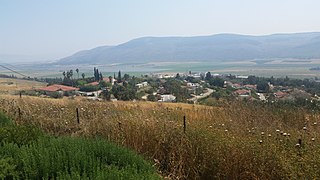
Sulam is an Arab village in north-eastern Israel. Known in ancient times as Shunama and Shunem, it is first mentioned in the Amarna Letters in the 14th century BCE. Archaeological excavations in the village attest to habitation extending from the Bronze Age through to modern times. Located near Afula, it falls under the jurisdiction of Bustan al-Marj Regional Council. In 2022 it had a population of 2,710.

al-Badhan is a Palestinian village in the Nablus Governorate in the North central West Bank, located 7.28 kilometres (4.52 mi) northeast of Nablus, and 1.5 kilometres (0.93 mi) to the north of Elon Moreh. According to the Palestinian Central Bureau of Statistics (PCBS), the village had a population of 3,171 inhabitants in 2017.

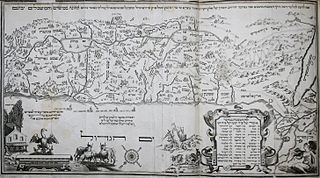
Many place names in Palestine were Arabized forms of ancient Hebrew and Canaanite place-names used in biblical times or later Aramaic formations. Most of these names have been handed down for thousands of years though their meaning was understood by only a few. The cultural interchange fostered by the various successive empires to have ruled the region is apparent in its place names. Any particular place can be known by the different names used in the past, with each of these corresponding to a historical period. For example, the city of Beit Shean, today in Israel, was known during the Israelite period as Beth-shean, under Hellenistic rule and Roman rule as Scythopolis, and under Arab and Islamic rule as Beisan.

Transjordan is an area of land in the Southern Levant lying east of the Jordan River valley. It is also alternatively called Gilead.

The Road of the Patriarchs or Way of the Patriarchs is an ancient north–south route traversing the land of Israel and the region of Palestine. The modern Highway 60 (Israel-Palestine) follows roughly the route of the Way of the Patriarchs. The name is used by biblical scholars because of mentions in biblical narratives that it was frequently travelled by Abraham, Isaac and Jacob.

Ma'ayan Harod or Ain Jalut is an all-year spring in the Harod Valley on the northwest corner of Mount Gilboa, that was the location of the 13th-century Battle of Ain Jalut. This was a major turning point in world history that saw the Mamluks inflict the first of two defeats on the Mongols that ultimately halted their invasion of the Levant and Egypt.

