
Special wards are a special form of municipalities in Japan under the 1947 Local Autonomy Law. They are city-level wards: primary subdivisions of a prefecture with municipal autonomy largely comparable to other forms of municipalities.
The City of Ballarat is a local government area in the west of the state of Victoria, Australia. It covers an area of 739 square kilometres (285 sq mi) and, in June 2018, had a population of 107,325. It is primarily urban with the vast majority of its population living in the Greater Ballarat urban area, while other significant settlements within the LGA include Buninyong, Waubra, Learmonth and Addington. It was formed on 6 May 1994 from the amalgamation of the City of Ballarat, Shire of Ballarat, Borough of Sebastopol and parts of the Shire of Bungaree, Shire of Buninyong, Shire of Grenville and Shire of Ripon.

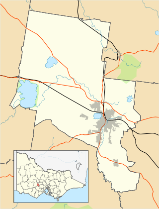
The City of Greater Bendigo is a local government area in Victoria, Australia, located in the central part of the state. It covers an area of 3,000 square kilometres (1,200 sq mi) and, in August 2021, had a population of 121,470. It includes the city of Bendigo and the towns of Axedale, Elmore, Heathcote, Marong, Raywood and Strathfieldsaye. It was formed in 1994 from the amalgamation of the former City of Bendigo with the Borough of Eaglehawk, Shire of Strathfieldsaye, Shire of Huntly and parts of the Rural City of Marong and Shire of McIvor. It is the state’s third largest economy base and is considered a service and infrastructure centre for north central Victoria. The city is surrounded by 40,000 hectares of regional, state and national parkland.

The Shire of Buloke is a local government area in Victoria, Australia, located in the western part of the state. It covers an area of 8,000 square kilometres (3,100 sq mi) and, in August 2021, had a population of 6,201. It includes the towns of Birchip, Charlton, Donald, Sea Lake and Wycheproof. It was formed in 1995 from the amalgamation of the Shire of Wycheproof, Shire of Birchip, Shire of Charlton, Shire of Donald, and parts of the Shire of Kara Kara.

The Shire of Campaspe is a local government area in Victoria, Australia, located in the northern part of the state. It covers an area of 4,519 square kilometres (1,745 sq mi) and in August 2021 had a population of 38,735.
The Shire of Gannawarra is a local government area in Victoria, Australia, located in the northern part of the state. It covers an area of 3,735 square kilometres (1,442 sq mi) and, in August 2021 had a population of 10,683.
The City of Latrobe is a local government area in the Gippsland region in eastern Victoria, Australia, located in the eastern part of the state. It covers an area of 1,426 square kilometres (551 sq mi) and in June 2018 had a population of 75,211. It is primarily urban with the vast majority of its population living within the four major urban areas of Moe, Morwell, Traralgon, and Churchill, and other significant settlements in the LGA include Boolarra, Callignee, Glengarry, Jeeralang, Newborough, Toongabbie, Tyers, Yallourn North and Yinnar. It was formed in 1994 from the amalgamation of the City of Moe, City of Morwell, City of Traralgon, Shire of Traralgon, and parts of the Shire of Narracan and Shire of Rosedale. The Yallourn Works Area was added in 1996. When formed, the municipality was called the Shire of La Trobe, but on 6 April 2000, it adopted its current name.

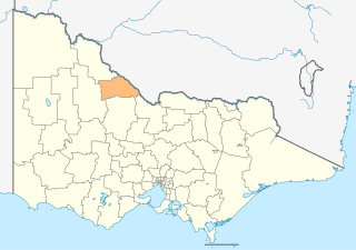
The Shire of Loddon is a local government area in Victoria, Australia, located in the northern part of the state. It covers an area of 6,696 square kilometres (2,585 sq mi) and in 2021 had a population of 7,759.

The Shire of Moorabool is a local government area in Victoria, Australia, located in the western part of the state. It covers an area of 2,111 square kilometres (815 sq mi) and, in June 2018, had a population of 34,158. It includes the towns of Ballan, Bacchus Marsh, Balliang, Mount Wallace, Myrniong, Blackwood, Greendale, Gordon, Korweinguboora and Mount Egerton, Bungaree, Elaine and Wallace. It was formed in 1994 from the amalgamation of the Shire of Bacchus Marsh, Shire of Ballan and parts of the Shire of Bungaree and City of Werribee.

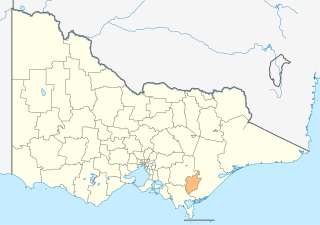
The Shire of Pyrenees is a local government area (LGA) in Victoria, Australia, located in the western part of the state. It covers an area of 3,435 square kilometres (1,326 sq mi) and in June 2018 had a population of 7,353.

A seniūnija is the smallest administrative division of Lithuania. An eldership may comprise a very small region consisting of few villages, one single town, or a part of a big city. Elderships vary in size and population depending on their location and nature. A few elderships make up a municipality. Šilainiai, Dainava, Verkiai, Žirmūnai and Pašilaičiai are the most populous elderates, with population counts over 40,000, around twice the population of some entire municipalities.

Moshi Urban District is an administrative district located in Kilimanjaro Region of Tanzania. The district is home to regional capital of Kilimanjaro Region, namely Moshi. The district covers an area of 63.39 km2 (24.48 sq mi). The district is surrounded on the west by Moshi Rural District, to the east by the Hai District. According to the 2022 Tanzania National Census, the population of Moshi Urban District was 221,733.

Moshi is one of the seven administrative districts of the Kilimanjaro Region of Tanzania. The district covers an area of 1,300 km2 (500 sq mi). The District is bordered to the north by the Rombo District, to the west by the Hai District, to the east by the Mwanga District and Kenya, and to the south by Simanjiro District of Manyara Region. The district also surrounds Moshi Municipal District on three sides. According to the 2012 census, the population of the Moshi District was 466,737. By 2022, the population had grown to 535,803.

Chümoukedima, formerly spelled Chumukedima, is a municipality in the Chümoukedima District of the Indian state of Nagaland. It is situated on the left bank of the Chathe and with its surrounding area that includes several other towns and villages, the Chümoukedima Metropolitan Area is the largest urban agglomeration in Nagaland in terms of area and third largest in terms of population, after Dimapur and Kohima.
The wards and electoral divisions in the United Kingdom are electoral districts at sub-national level, represented by one or more councillors. The ward is the primary unit of English electoral geography for civil parishes and borough and district councils, the electoral ward is the unit used by Welsh principal councils, while the electoral division is the unit used by English county councils and some unitary authorities. Each ward/division has an average electorate of about 5,500 people, but ward population counts can vary substantially. As of 2021 there are 8,694 electoral wards/divisions in the UK. An average area of wards or electoral divisions in the United Kingdom is 28.109 km2 (10.853 sq mi).
A ward is the smallest administrative unit of Ethiopia: a ward, a neighbourhood or a localized and delimited group of people. Somali word that has meaning of collected people where water is fairly sufficient and available to prolongue their pastoralist livelihood. It is part of a district, itself usually part of a zone, which in turn are grouped into one of the regions or two chartered cities that comprise the Federal Democratic Republic of Ethiopia.

The Council of the Isles of Scilly is a sui generis local government authority covering the Isles of Scilly off the west coast of Cornwall, England. It is currently made up of 16 seats, with all councillors being independents. The council was created in 1891 as the Isles of Scilly Rural District Council and was renamed in 1974.

Bidhannagar Municipal Corporation is the local government responsible for the civic infrastructure and administration of Salt Lake and Rajarhat areas in Greater Kolkata.
Lindi Municipal District is one of the eight administrative districts of Lindi Region in Tanzania. The district covers an area of 1,064 km2 (411 sq mi).The district is comparable in size to the land area of the nation state of Sao Tome and Principe. It is entirely bordered on land by Lindi District and its faces the Indian Ocean to the east. Lindi Municipal District hosts the region's capital is located in the ward of Ndoro in the town of Lindi. According to the 2012 census, the district has a total population of 78,841.
Bani al-Ward is a sub-district located in Mudhaykhirah District, Ibb Governorate, Yemen. Bani al-Ward had a population of 1,539 according to the 2004 census.
