
Nyhavn is a 17th-century waterfront, canal and entertainment district in Copenhagen, Denmark. Stretching from Kongens Nytorv to the Inner Harbour just south of the Royal Playhouse, it is lined by brightly coloured 17th and early 18th century townhouses and bars, cafes and restaurants. The canal harbours many historical wooden ships.

Valby ( ) is one of the 10 official districts of Copenhagen Municipality, Denmark. It is in the southwestern corner of Copenhagen Municipality, and has a mixture of different types of housing. This includes apartment blocks, terraced housing, areas with single-family houses and allotments, plus the remaining part of the old Valby village, around which the district has formed, intermingled with past and present industrial sites.

Vanløse is one of the 10 official districts of Copenhagen Municipality, Denmark. It lies on the western border of the municipality. Vanløse covers an area of 6.69 km2, and has a population of 36,115, making Vanløse the smallest district of Copenhagen, by population.
Kastrup is a suburb of Copenhagen, Denmark, on the east coast of Amager in Tårnby Municipality. It is the site of Copenhagen Airport. In Danish, the airport is often called Kastrup Lufthavn or Københavns Lufthavn, Kastrup.
Østerport station is a metro, S-train and main line railway station in Copenhagen, Denmark. It is located between the districts of Indre By and Østerbro, and is named for the historic Østerport city gate, near the original location of which it is located.
Hvidovre station is a railway station on the Taastrup radial of the S-train network in Copenhagen, Denmark. It is located about 1 km north of the old village of Hvidovre, in the far northwestern corner of Hvidovre Municipality. The station thus also serves areas in the neighbouring Rødovre and Copenhagen municipalities, whereas the larger part of Hvidovre municipality is actually better served by stations on the Køge radial.

Glostrup station is a commuter rail railway station serving the railway town/suburb of Glostrup west of Copenhagen, Denmark. It is located close to the historical, administrative and commercial centre of Glostrup Municipality, but also serves Brøndbyvester in Brøndby Municipality, the boundary of which comes within a few hundred metres from the station. The station is connected to the nearby Glostrup Shopping Center via an underground walkway, the same walkway which is used to access the platforms.

Hellerup station is a regional and S-train railway station serving the district of Hellerup in Copenhagen, Denmark. It is served by regional trains on the Coast Branch, as well as S-trains.

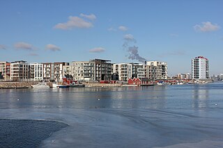
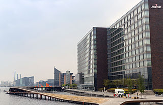
Nordhavnen, or Nordhavn, is a harbour area at the coast of the Øresund, founded at the end of the 19th century in Copenhagen, Denmark. It covers an area of more than 2 km2.

Carlsberg, is an area located straddling the border of Valby and Vesterbro districts in central Copenhagen, Denmark approximately 2.4 km from the City Hall Square. The area emerged when J.C. Jacobsen founded his original brewery in the district in 1847. The first brewing took place on 11 November 1847 and production continued until 30 October 2008, when production was moved to Fredericia in Jutland. The Jacobsen House Brewery is however still located in the district and produces specialty beers. The entire brewery grounds spread over more than 30 hectares and is currently being transformed into a new city district in Copenhagen.

The Jesus Church is a church situated just off Valby Langgade in the Valby district of Copenhagen, Denmark. It was commissioned by second-generation Carlsberg brewer Carl Jacobsen and designed by Vilhelm Dahlerup. Noted for its extensive ornamentation and artwork, it is considered to be one of the country's most idiosyncratic and unconventional examples of church architecture. The church was built as a mausoleum for Carl Jacobsen and his family and is located close to their former house as well as the former Carlsberg brewery site. Their sarcophagi lie in the crypt. Throughout the church, there are ornaments and inscriptions associated with the family.
Sluseholmen is an artificial peninsula in the South Harbour of Copenhagen, Denmark. It takes its name from Slusen, a lock immediately to the south, regulating water levels in the harbor. Previously the site of heavy industry and part of the Southern Docklands of Port of Copenhagen, Sluseholmen has, since the turn of the millennium, undergone massive redevelopment, transforming it into a mainly residential district known for its canals and maritime atmosphere. It is connected to Teglholmen by the Teglværk Bridge.

Churchillparken is a public park in Copenhagen, Denmark, occupying a tract of land between Kastellet, a 17th-century fortress, and the street Esplanaden. Located on the former esplanade which used to surround Kastellet, the area has a long history as a greenspace but received its current name in 1965 to commemorate Winston Churchill and the British assistance in the liberation of Denmark during World War II.

Aalborg railway station is the main railway station serving the city of Aalborg, Denmark. It is located in central Aalborg, on the southwestern edge of the city center, with entrances from John F. Kennedys Plads and access to platforms from Kildeparken.
Kalvebod Brygge is a waterfront area in the Vesterbro district of Copenhagen, Denmark. The name also refers to a section of the Ring 2 ring road which follows the waterfront from Langebro in the north to the H. C. Ørsted Power Station in the south. The area is dominated by office buildings, Tivoli Conference Center, several hotels and the shopping centre Fisketorvet.

Store Kongensgade is the longest street in central Copenhagen, Denmark. It extends northeast from Kongens Nytorv to Esplanaden, running parallel to Bredgade, where it breaks left, continuing northwest to Grønningen.

Enghave Brygge is a waterfront area in the Southern Docklands of Copenhagen, Denmark. It is located between Vesterbro to the north and Teglholmen to the south, and opposite Islands Brygge across the water. The area is undergoing significant development, with the northern half now housing around 2.000 inhabitants, and construction of apartment blocks in the southern half is underway. Enghave Brygge is characterized by canals, giving the area the impression of a maritime city like Venice or Amsterdam, as well as the nearby Christianshavn neighbourhood. The Enghave Canal which runs from north to south across Enghave Brygge is a major defining landmark.

Godthåbsvej is a street in the northwestern part of Copenhagen, Denmark. It begins at Bülowsvej in Frederiksberg as the direct continuation of Rosenørns Allé/Rolighedsvej and passes through Vanløse before reaching Bellahøj in Brønshøj. A metro station on the Copenhagen Metro City Circle Line is located at Aksel Møllers Have.
Valby Langgade is one of the main streets of the Valby district of Copenhagen, Denmark. The c. 3.2 km long street runs from the southern end of Pile Allé and the Carlsberg neighbourhood in the east to Roskildevej at Damhus Lake in the west. The square and side street Valby Tingsted was the centre of the original village of Valby.

Vigerslev Allé is a major artery in the Valby district of Copenhagen, Denmark. It runs from Enghavevej in the northeast to Hvidovrevej in Hvidovre in the southwest. The first part of the street runs east-west, following the south side of the main railway line through Copenhagen on its way to Toftegårds Plads, the largest square in Valby. It later passes under the S-train network's Ring Line at Vigerslev Allé station before continuing southwest to the Ring 2 ring road just before entering Hvidovre Municipality at Harrestrup Å in Vigerslevparken.
