Jamaica is a neighborhood in the New York City borough of Queens. It is mainly composed of a large commercial and retail area, though part of the neighborhood is also residential. Jamaica is bordered by Hollis to the east; St. Albans, Springfield Gardens, Rochdale Village to the southeast; South Jamaica to the south; Richmond Hill and South Ozone Park to the west; Briarwood to the northwest; and Kew Gardens Hills, Jamaica Hills, and Jamaica Estates to the north.

Squirrel Hill is a residential neighborhood in the East End of Pittsburgh, Pennsylvania, United States. The city officially divides it into two neighborhoods, Squirrel Hill North and Squirrel Hill South, but it is almost universally treated as a single neighborhood.

Oakland is the academic and healthcare center of Pittsburgh and one of the city's major cultural centers. Home to three universities, museums, hospitals, shopping venues, restaurants, and recreational activities, this section of the city also includes two city-designated historic districts: the mostly residential Schenley Farms Historic District and the predominantly institutional Oakland Civic Center Historic District, as well as the locally-designated Oakland Square Historic District.

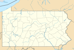
Downtown Pittsburgh, colloquially referred to as the Golden Triangle, and officially the Central Business District, is the urban downtown center of Pittsburgh, Pennsylvania, United States. It is located at the confluence of the Allegheny River and the Monongahela River whose joining forms the Ohio River. The triangle is bounded by the two rivers.
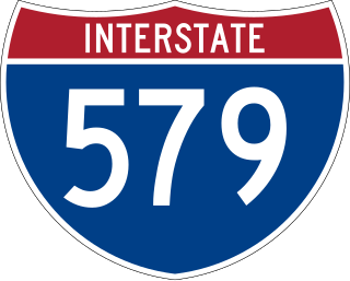
Interstate 579 (I-579) is a north–south Interstate Highway entirely within Pittsburgh, Pennsylvania. The highway is 2.73 miles (4.39 km) long. I-579 is also known as the Crosstown Boulevard since it crosses the backside of Downtown Pittsburgh.

East Liberty is a neighborhood in Pittsburgh, Pennsylvania's East End. It is bordered by Highland Park, Morningside, Stanton Heights, Garfield, Friendship, Shadyside and Larimer, and falls largely within Pittsburgh City Council District 9, with a few areas in District 8. One of the most notable features in the East Liberty skyline is the East Liberty Presbyterian Church, which is an area landmark.
East Allegheny, also known as Deutschtown, is a neighborhood on Pittsburgh's North Side. It has a ZIP code of 15212, and has representation on Pittsburgh City Council by the council member for District 1. The Pittsburgh Bureau of Fire houses 32 engines and 32 trucks in Deutschtown.

The Boulevard of the Allies is a mostly four-lane road in the U.S. state of Pennsylvania, connecting Downtown Pittsburgh with the Oakland neighborhood of the city. Because of its lengthy name, locals sometimes refer to it as simply "The Boulevard".

Pennsylvania Route 380, also known as J.F. Bonetto Memorial Highway and within the city of Pittsburgh Bigelow Boulevard, Baum Boulevard and Frankstown Road, is a 32.80-mile-long (52.8 km) state highway in western portions of the U.S. state of Pennsylvania. The western terminus of the route is at Interstate 579 in downtown Pittsburgh near PPG Paints Arena. The eastern terminus is at Pennsylvania Route 286 in Bell Township, near the hamlet of Wakena.

Pennsylvania Route 885 is a 14.1-mile-long (22.69 km) north–south state highway in the U.S. state of Pennsylvania. It runs from Pennsylvania Route 837 in Clairton north to Interstate 579 in Pittsburgh. The route is entirely within Allegheny County and serves as a connector between the city of Pittsburgh and its southern suburbs.

The Historic Michigan Boulevard District is a historic district in the Loop community area of Chicago in Cook County, Illinois, United States encompassing Michigan Avenue between 11th or Roosevelt Road, depending on the source, and Randolph Streets and named after the nearby Lake Michigan. It was designated a Chicago Landmark on February 27, 2002. The district includes numerous significant buildings on Michigan Avenue facing Grant Park. This section of Michigan Avenue includes the eastern terminus of U.S. Route 66. The district is one of the world's best known one-sided streets rivalling Fifth Avenue in New York City and Edinburgh's Princes Street. It lies immediately south of the Michigan–Wacker Historic District and east of the Loop Retail Historic District.

The Cass Park Historic District is a historic district in Midtown Detroit, Michigan, consisting of 25 buildings along the streets of Temple, Ledyard, and 2nd, surrounding Cass Park. It was listed on the National Register of Historic Places in 2005 and designated a city of Detroit historic district in 2016.

The Paramount Film Exchange is a historic film exchange building at 1727 Boulevard of the Allies in the Uptown or Bluff neighborhood of Pittsburgh, Pennsylvania, designed in 1926 by R. E. Hall Co. architects from New York City. In 2010, the building was bought by arts-oriented local entrepreneurs who founded the Paramount Film Exchange (PFEX), Inc., to redevelop the then-abandoned building in a historically sensitive manner.

The South Green Fire Station, also known as the Engine Company 1 Fire Station, is at 197 Main St. in downtown Hartford, Connecticut. Built in 1927, it is an architecturally distinctive example of Classical and Collegiate Gothic Revival architecture, designed by a prominent local firm. The station, as well as the former fire equipment maintenance house behind it at 36 John Street, were listed on the National Register of Historic Places in 1989. The station presently houses Engine Company 1 and Ladder Company 6 of the Hartford Fire Department.

Pittsburgh Playhouse is Point Park University's performing arts center located in Pittsburgh, Pennsylvania. It houses three performance spaces and is home to The Rep, Point Park's resident professional theatre company, as well as three student companies—Conservatory Theatre Company, Conservatory Dance Company, and Playhouse Jr. The Conservatory Theatre Company offers five productions each year that are performed by undergraduate students at Point Park; each season consists of a mixture of established plays and musicals, as well as occasional new works.

Joseph Franklin Kuntz was an American architect who was based in Pittsburgh, Pennsylvania. He designed at least eighteen armories in Western Pennsylvania, with the W.G. Wilkins Company, following the 1905 creation of a state armory board.

The U.S. city of Pittsburgh, Pennsylvania, was home to a "small, but busy" Chinatown, located at the intersection of Grant Street and Boulevard of the Allies in Downtown Pittsburgh where only one Chinese restaurant remains. The On Leong Society was located there. According to the article, "... the first Chinese community in Pittsburgh developed around Wylie Avenue above Court Place," according to a 1942 newsletter of the American Service Institute of Allegheny County. The Chinatown spread to Grant Street, and then "... to Water Street and then spread out to Second and Third avenues."

Thomas H Scott was an architect in Pittsburgh, Pennsylvania. He is credited with designing the Benedum-Trees Building (1905) in downtown Pittsburgh at 221 Fourth Avenue. It was added to the List of Pittsburgh History and Landmarks Foundation Historic Landmarks in 1973. The Garden Theater (1915) in Pittsburgh's Central Northside neighborhood, also designed by Scott, was placed on the List of City of Pittsburgh historic designations by Pittsburgh City Council on March 25, 2008.

The Salvation Army Building is a historic building located at 425–435 Boulevard of the Allies in Pittsburgh, Pennsylvania. The building was constructed in 1924 with a large eastern addition in 1930 in the Late Gothic Revival style. The multi-purpose building originally housed the headquarters, residential and recreational functions for the Salvation Army of Western Pennsylvania from 1924 until 2008. It was listed on the National Register of Historic Places on February 2, 2016.
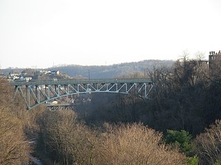
The Charles Anderson Memorial Bridge is a steel deck truss bridge located in Pittsburgh, Pennsylvania, United States. The bridge carries the four-lane roadway of Boulevard of the Allies across a ravine known as Junction Hollow, connecting the neighborhoods of Central Oakland and South Oakland with Schenley Park. The bridge also spans the Junction Hollow Trail and P&W Subdivision railroad tracks which run along the bottom of the valley.